Walls of Genoa
The Italian city of Genoa, chief town of Liguria and ancient capital of the Republic of Genoa, during its long history had been defended by walls. To this day, large portions of these walls remain, and Genoa has more and longer walls than any other city in Italy. The main city walls are known as “Ninth century walls”, "Barbarossa Walls" (12th century), "Fourteenth century walls", "Sixteenth century walls" and "New Walls" (17th century).
Ancient walls
Ancient era and Middle Ages

In Roman times the original centre of Genoa, on the Sarzano hill, may have been defended by a wall, but there is no archaeological or documentary evidence of its existence.
The first known city walls were built in the 9th century, when thanks to Berengar II of Italy the city gained a wide autonomy, with subsequent economic development and population increase. The first walls, which included Sarzano hill, had three gates (the Serravalle gate, at the north side of the church of San Lorenzo, another on the hill of Saint Andrew, near the site of the future Porta Soprana and another one at the end of “Via Canneto il curto”, near the church of San Peter).
The settlement enclosed by the walls and the coastline occupied about twenty-two hectares. Some small settlements (housing mainly workmen and artisans), which had grown around churches, monasteries and feudal palaces, remained outside the walls.
Barbarossa walls
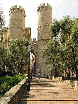
In 1155 the defensive wall was extended to north-west to include also the new settlements out of the walls. The walls culminated on the top of St. Andrew hill, with Porta Soprana.
The new walls greatly expanded the area contained in it, compared to the previous one, including an area of 55 hectares.
The construction of the walls dragged until 1163: in that year, due to the international political situation, and particularly the relations with emperor Frederick Barbarossa led to an acceleration of work, as Caffaro vouched for, and in fifty-three days the works were completed, thanks to the effort of the entire population.
The three main gates had a monumental look, with high semicircular towers. Two of them survive nowadays, “Porta Soprana” and “Porta dei Vacca”; the third one, the Porta Aurea ("Golden Gate"), already partially demolished in the 18th century, was completely demolished in the second half of 20th century. In the 13th century the Old Pier peninsula, at the southern limit of the port, was also included inside the walls, completing by this the fortifications on the sea side of the city.
The 14th century expansion
In the 14th century urban expansion of the city, caused by the increase in commercial activity, led to a new extension of walls to encompass the new quarters which stood at west and east of the original city centre.
Between 1320 and 1327, the east side of the walls was extended to include Carignano hill, passing where now are the esplanade of Acquasola and the Monumental Bridge. This walls section had two gates: Porta dell'Acquasola and Porta degli Archi. Hence the ancient walls, still visible, continue with the names of Mura of Santa Chiara, Mura del Prato and Mura delle Cappuccine, ending with a cliff overlooking the sea.
From 1347 and 1350 another extension was built toward west, from the fort of Castelletto to the new St. Thomas Gate, near the present Principe railway station. This stretch of walls included a series of towers and gates, no longer existing (Carbonara, Pietraminuta, St. George, the above mentioned St. Thomas Gate and another tower in the place where nowadays is Castello d'Albertis). After this enlargement the city wall ran for 4,550 meters, containing an area of 155 hectares.
The walls in the 16th century
In the 16th century, the walls were no longer able to stand an attack with the new firearms so they were modified to create new Star forts.

When in 1528 Andrea Doria placed the republic under the protection of the Spaniards, he, fearing the possibility of new attacks by French army, promoted the modernization of the city walls, projected by Giovanni Maria Olgiati and carried out in the third decade of the 16th century. The “Barbarossa walls” and their extensions of 14th century were modernized, by replacing the old square towers with triangular bastions and building new curtains with scarp profile.

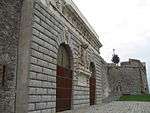
Were also completed walls along the sea, including the entire shoreline between the St. Thomas gate and the Molo Vecchio (Old Pier). In this stretch of wall some gates were built, one for each pier of the port. At the end of Molo Vecchio in the second half of this century Galeazzo Alessi designed Porta Siberia, splendid example of Renaissance military architecture. From here the walls are linked to those already existing on the sea side of Sarzano and Carignano hills and reached the mouth of Bisagno. Of the three main gates of the 16th century walls, today still exist Porta Siberia and the Porta degli Archi (moved from the original location for the opening of Via XX Settembre), while the St. Thomas Gate was demolished to build the Principe railway station.
The Mura Nuove (New Walls)

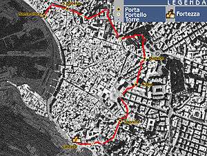
The “Mura Nuove” (New Walls) are the last and imposing city walls built along the ridge of the hills encircling Genoa downtown, and were built in the first middle of 17th century.
Arriving in Genoa from the sea the view of the city is characterized by the line of New Walls with their fortifications, on the ridge of the hills, above the hilly quarters which grew after World War II; coming from the north, by train or car, the first visible structure is the mass of fort Diamante, high on the mount on left bank of the Val Polcevera, and the fort Fratello Minore. Shortly after, on the ridge in the distance is fort Begato, included in the line of bastions that rise up to the top of Mount Peralto, where is fort Sperone with its high walls.
The “New Walls”, the last and largest city walls, were built since 1626, after the repeated attempts of Charles Emmanuel I of Savoy to invade Genoa had convinced the Government of the need of a new and more powerful defensive walls.
Although this defensive wall had already been suggested in 1568, the Government of Republic of Genoa started the work in 1626, following the failed attack on May 10, 1625 of a French-Piedmontese army at the Pertuso Pass (where in memory of the event was later built the Shrine of Nostra Signora della Vittoria, meaning "Our Lady of Victory") .
In less than four years, between 1629 and 1633, an army of diggers, bricklayers and stonemasons (eight hundred according to some sources, even three thousand according to others), divided into twenty-eight teams, raised curtains and bastions along the two ridges overlooking the valleys of Polcevera and Bisagno.
The project of walls was carried out by mathematicians Vincenzo Maculano and Giovanni Battista Baliani, a friend of Galileo Galilei. The supervision of work was entrusted to Ansaldo De Mari, with the cooperation of the Lombard architect Bartolomeo Bianco [1]

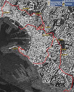
The “New Walls” extended for almost twenty kilometers, of which seven along the coastline. Their construction caused the incorporation of the quarter of San Teodoro within the walls. The walls, seen from above, have a triangular shape, the vertices being the mount Peralto, the lighthouse and the mouth of Bisagno.
Fortifications beginning from Lanterna climb the Granarolo hill then reach mount Peralto, where the curtains overlooking Val Polcevera and those overlooking Val Bisagno meet, then get off the plain along the final stretch of Bisagno, protected by powerful bastions, known as “Fronti Basse”. The waterfront was completed to defend the coastline from the Lanterna up to the western limit of the old walls (St. Thomas Gate).
This structure was built on the hills even on steep slopes, in areas still sparsely populated today. This has contributed to their preservation, while the sections closest to the city were mostly demolished for the construction of new quarters and infrastructure.
The length of “New Walls” reached 19,560 meters, enclosing an area of 903 hectares (nearly five times to 197 hectares included in ”old wall” until the 16th century).[2]
The Eastern ridge

From Fort Sperone, after a short stretch towards south-east (Peralto Walls) the walls meet the Fort Castellaccio and then different section of walls, named “Chiappe”, “Sant'Erasmo”, “San Bernardino” and “Zerbino”, ending above the Brignole railway station. Once they continued with the "Walls of Montesano", demolished in the 19th century to allow building the railway station.
The city's urban expansion eastward, in the last decades of the 19th century caused the demolition of one of the most powerful and evocative parts of the New Walls, the so-called “Fronti Basse”, a huge rampart that ran straight, with two large bastions in the plain on the right bank of Bisagno. This large structure linked the New Walls with the “Sixteenth century walls”, from the place where now is the railway station up to “Walls of Prato”.
In the “Fronti Basse” there were two gates, the monumental Porta Pila (by Bartolomeo Bianco), at the end of Via Giulia (due to the realization of Via XX Settembre the gate was moved to behind the Brignole station), and “Porta Romana” at the end of Via San Vincenzo, where the ancient road to the east quarters began.
The Western ridge

From the top of Mount Peralto, where is Fort Sperone, walls come down towards the southwest in a straight line to Fort Begato, then continue to fall along the panoramic road which runs along the curtain walk, taking first the name "Walls of Granarolo", near the gate of the same name, then “Walls of Monte Moro”. After Fort Tenaglia, the walls continue as "Walls of Porta Murata" to reach the “Angeli Gate” and the “Walls of Angeli”, where nowadays they stop abruptly due to the excavation, in the thirties of the 20th century, of the San Benigno hill, an imposing rocky ridge where formerly stood the church and monastery of San Benigno, turned into barracks. The “walls of San Benigno” ran along the ridge of this hill and went to the lighthouse of Lanterna and the Lanterna Gate.

The waterfront
With the 17th century expansion the walls along the coast were reinforced with new bastions and extended beyond St. Thomas Gate to Capo Faro, where they met those descending along the western ridge. Due to port expansion most of the walls along the sea were demolished: only a short stretch survives, recently enhanced with a walk from the Ferry Terminal to the lighthouse. Close by the lighthouse there was the monumental Lantern Gate, projected by Antonio Ponsonelli, built in 1633 and demolished after building, in 1830, a new gate at a short distance, “Porta Nuova” (New Gate), simple but more suitable for growing traffic.
The fortresses
Among the 18th century and the first half of the nineteenth along the perimeter of the walls were built some fortifications, Castellaccio, Sperone (on the top of Mount Peralto), Begato and Tenaglia. Other forts were built in different periods in the hills outside the city walls and along the ridge on the left bank of Val Bisagno. Most of the Genoese fortifications (total 16) are still visible and some of them also visited.
In the second half of 18th century, immediately after the Austrian siege of 1747, the fortifications were expanded with the construction of four fortresses external to the walls: Diamante, Quezzi, Richelieu and Santa Tecla, designed by French military engineers Jacques De Sicre and Pierre De Cotte.
During the siege of Genoa of April 1800, these forts were the site of many harsh fightings between French and Austrian armies.
After the annexation of the Napoleonic Ligurian Republic to the Kingdom of Sardinia, decided by the Congress of Vienna in 1814, the Savoy government built (1815–1840) a series of forts, towers and coastal batteries, making Genoa the best equipped fortress in the Mediterranean. The designer of this last phase of construction of the Genoese fortifications was major Giulio D'Andreis.
Forts along the perimeter of New Walls include:
- Fort Castellaccio (including Torre Specola)
- Fort Sperone
- Fort Begato
- Fort Tenaglia
Western Forts (Sampierdarena) include:
- Fort Crocetta
- Fort Belvedere (no longer existing)
Forts on the ridges north of the walls include:
- Fort Puìn
- Fort Fratello Minore
- Fort Fratello Maggiore (demolished in 1932)
- Fort Diamante
Eastern Forts (Val Bisagno, Albaro):
- Fort San Giuliano (now headquarters of the Provincial Command of Carabinieri)
- Fort San Martino
- Fort Santa Tecla
- Fort Quezzi
- Fort Richelieu
- Fort Monteratti

19th century towers
In 1820 the Engineering Military Corps of the Kingdom of Sardinia started to build a set of towers, externally to the walls, similar to Martello towers. A few years later, due to costs and because considered useless, their construction was stopped. Only three of them were completed: Torre Quezzi, Torre San Bernardino and Torre Zerbino (the last one no longer existing). Others still exist in the condition in which they were left when the work was stopped, missing the second floor and the roof.

New Walls today
The new walls and forts, once disappeared the purposes for which they were planned, were decommissioned from military property in 1914. After this date some of these structures had been used as warehouses, jails for prisoners of war during World War I, anti-aircraft emplacements or houses for evacuees during World War II. Others were given to private ownership or left abandoned. Nowadays, although they are public property, their condition is not uniform: the main fortresses have recently been restored and may be visited on request, other, even if in state of decay, are freely visited, others were given to private owners and some of them host TV or mobile phone plants.
The only fort still used by a military institution is Fort San Giuliano, which overlooks Corso Italia, in the quarter of Albaro, now headquarters of the Provincial Command of Carabinieri.
The "New Walls" and the forts are now included in the "Parco Urbano delle Mura" (City Park of Walls), having a surface of 876 hectares, which is the largest green "lung" of Genoa, and provides the possibility of different excursions of historic and wildlife interest.[3]
References
- ↑ Bartolomeo Bianco projected in Genoa some of Via Balbi palaces and worked with De Mari also to the walls of Vado Ligure.
- ↑ Riccardo Dellepiane, Mura e fortificazioni di Genova, Nuova Editrice Genovese, Genoa, 1984 (reprinted in 2008, ISBN 978-88-88963-22-8), page 65
- ↑ http://www.turismo.comune.genova.it/spip.php?article298
| Wikimedia Commons has media related to Walls of Genoa. |
Sources
- Stefano Finauri, Forti di Genova: storia, tecnica e architettura dei fortini difensivi, Edizioni Servizi Editoriali, Genoa 2007, ISBN 978-88-89384-27-5
- Riccardo Dellepiane, Mura e fortificazioni di Genova, Nuova Editrice Genovese, Genoa 1984 (reprinted in 2008, ISBN 978-88-88963-22-8)
- Piera Melli, La città ritrovata. Archeologia urbana a Genova (1984–1994), Tormena Editore 1948, Genoa, 1996 - ISBN 88-86017-62-6
- Ennio Poleggi, Paolo Cevini, Le città nella storia d'Italia, Laterza, Rome-Bari 1981
- Pietro Barozzi, Mura e forti di Genova, on "L'Universo", bimonthly magazine of “Istituto Geografico Militare”, year LVII - N.1 January–February 1977
- Corinna Praga, Porta Soprana: le mura del Barbarossa, SAGEP editrice, Genoa 1998 - ISBN 88-7058-690-1
- Guida d’Italia – Liguria, TCI, Milan 2009
- La mia gente, Il Secolo XIX, Genoa 1982-1983
External links
- Genoa’s Fortresses
- Genoa’s Fortresses on the official site of the Municipality of Genoa
- Fortress of Genoa on www.forti-genova.com (Italian)
- Fortress of Genoa on www.fortidigenova.com (Italian)
- Fortress of Genoa on ww1.zenazone.it (Italian)
- Photo gallery of Genoa’s Fortresses