Wall, Staffordshire
| Wall | |
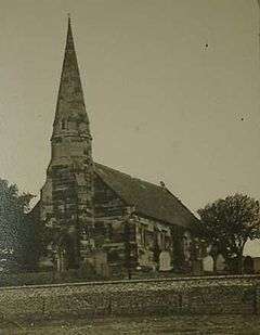 St John's Church in the 19th century |
|
 Wall |
|
| Population | 433 (2011) [1] |
|---|---|
| OS grid reference | SK103070 |
| Civil parish | Wall |
| District | Lichfield |
| Shire county | Staffordshire |
| Region | West Midlands |
| Country | England |
| Sovereign state | United Kingdom |
| Post town | LICHFIELD |
| Postcode district | WS14 |
| Dialling code | 01543 |
| Police | Staffordshire |
| Fire | Staffordshire |
| Ambulance | West Midlands |
| EU Parliament | West Midlands |
| UK Parliament | Tamworth[2] |
|
|
Coordinates: 52°39′29″N 1°51′14″W / 52.658°N 1.854°W
Wall is a small village and civil parish[3] in Staffordshire, England, just south of Lichfield. It lies on the site of the Roman settlement of Letocetum.
The nearby junction of the A5 and A5127 roads and the M6 Toll motorway is often referred to as Wall junction.
The parish includes the small villages of Pipehill, Hilton, Chesterfield and the tiny hamlet of Aldershawe, which is about half a mile north of the village of Wall.
Wall has an infrequent bus service operated by Arriva Midlands, numbered 35B. It operates every 2 hours Monday to Saturday. The route goes from Walsall to Lichfield via Aldridge, Stonnall and Shenstone.[4]
History
Letocetum
The earliest evidence of settlement in Wall is the discovery of flints dating to the Neolithic period found in the upper part of Wall village.[5] The first detailed evidence of human settlement comes in the 1st century. A Roman fort named Etocetum (reflecting an indigenous name reconstructed as *Lētocaiton or "Greywood") was established at Wall in or soon after AD 50 to accommodate Legio XIV, then advancing towards Wales. A fort was certainly built in the upper area of the village near to the present church in 50s or 60s and Watling Street was constructed to the south in the 70s. A bath house and mansio was built on the lower ground south west of the fort in the late 1st century for use by its soldiers. It was later used by the inhabitants of a civilian settlement which grew up around Watling Street. In the 2nd century the settlement covered approximately 30 acres west of the later Wall Lane. By the 1st or 2nd century there was a burial area beyond the western end of the settlement.[5] The settlement was mentioned in the Antonine Itinerary.
In the late 3rd or early 4th century the eastern part of the settlement of approximately 6 acres, between the present Wall Lane and Green Lane and straddling Watling Street, was enclosed with a stone wall surrounded by an earth rampart and ditches. Civilians continued to live inside the settlement and on its outskirts in the late 4th century. The settlement appears to have declined rapidly soon after the Romans left Britain in AD 410 and the focus of settlement shifted to Lichfield.[5] Despite this shift of population, Ford identifies the community as the Cair Luit Coyd[6] ("Fort Grey Woods") listed by Nennius among the 28 cities of Britain in his History of the Britains,[7] previously identified with Lincoln or Lichfield.[8]
Modern Wall
Development of Wall since the Romans has been slow, and it has never developed beyond a small village. The earliest medieval settlement may have been on the higher ground around Wall. Wall House on Green Lane, although dating from the 18th century, is probably on the site of the medieval manor house. Wall Hall to the south also dates from the mid 18th century but replaced a house which existed in the 17th century. By the late 18th century several dwellings were built on Watling Street west of Manor Farm and formed the lower part of the village. In 1837 the church was built, which in 1843 was consecrated as the Parish Church of St John. The church's architects were Moffat and Scott, Scott later became the internationally renowned architect Sir Gilbert Scott. The Trooper Inn existed by 1851. In the 1950s ten council houses were built on a road called The Butts. The re-routing of the A5 around Wall, as the Wall By-pass in 1965, relieved the village of traffic, re-establishing its quiet nature.[5]
Geography
Topography
The upper part of Wall village lies at 114m on the edge of a plateau; the lower part to the south of Watling Street lies 16m lower. At Aldershawe the land lies at 130m, and it is the same level at Pipehill and Muckley Corner.
Geology
The north of the parish including Pipehill, Aldershawe and east parts of Wall are underlain with Bromsgrove Sandstone. The south of the parish including west Wall, Hilton and Chesterfield are underlain by Wildmoor Sandstone. A narrow gravel terrace runs north west from Wall to a point south of Pipehill where it merges into an area of Boulder Clay. South of Wall glaciofluvial deposits overlie the area including, Hilton and Chesterfield.
Hydrology
Black brook runs below the gravel terrace west of Wall. Crane brook runs through Hilton and Chesterfield and is the source for Hilton's main street name of 'Cranebrook Lane'. A spring south of Pipe Grange feeds a stream which flows east to Leamonsley Brook. A spring rising in Aldershawe was used for centuries as the source for drinking water for the city of Lichfield. Conduits were dug from Aldershawe to Lichfield where they supplied water from various conduits around the city.
References
- ↑ "Civil Parish population 2011". Retrieved 2 December 2015.
- ↑ "United Kingdom Parliament". Retrieved 18 September 2009.
- ↑ "Names and codes for Administrative Geography". Office for National Statistics. 31 December 2008. Retrieved 15 September 2009.
- ↑ "Arriva Bus Services/accessdate=24 January 2016".
- 1 2 3 4 Greenslade, M.W. (1990), A History of the County of Stafford: Volume XIV: Lichfield, Victoria County History, ISBN 978-0-19-722778-7
- ↑ Nennius (attrib.). Theodor Mommsen (ed.). Historia Brittonum, VI. Composed after AD 830. (Latin) Hosted at Latin Wikisource.
- ↑ Ford, David Nash. "The 28 Cities of Britain" at Britannia. 2000.
- ↑ Wolcott, Darrell. "Glast and the Glastening". Center for the Studies of Ancient Wales (Jefferson), 2010.
External links
| Wikimedia Commons has media related to Wall, Staffordshire. |