Waimea, Kauai County, Hawaii
| Waimea, Hawaii | |
|---|---|
| Census-designated place | |
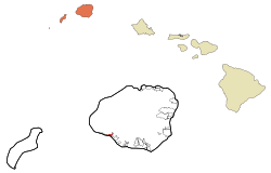 Location in Kauai County and the state of Hawaii | |
| Coordinates: 21°57′42″N 159°40′25″W / 21.96167°N 159.67361°WCoordinates: 21°57′42″N 159°40′25″W / 21.96167°N 159.67361°W | |
| Country | United States |
| State | Hawaii |
| Counties | Kauai |
| Area | |
| • Total | 1.2 sq mi (3.3 km2) |
| • Land | 1 sq mi (2.7 km2) |
| • Water | 0.2 sq mi (0.6 km2) |
| Population (2010) | |
| • Total | 1,855 |
| • Density | 1,489.2/sq mi (541.5/km2) |
| Area code(s) | 808 |
Waimea (literally, "red water" in Hawaiian[1]) is a census-designated place (CDP) in Kauaʻi County, Hawaiʻi, United States. The population was 1,855 at the 2010 census. The first Europeans to reach Hawaii landed in Waimea in 1778 (giving rise to Kauai's cheeky slogan: "Hawaii's Original Visitor Destination").
History
Between 200 to 600 AD, the first settlers arrived in Kaua‘i from the Marquesas Islands. It is not clear why the voyagers sought a new homeland—whether they were escaping war, famine, or were simply driven by the desire to explore. Along with them, they brought taro, sweet potato, pigs and fowl, as well as seeds. They were experienced farmers and fishermen, with advanced irrigation techniques that allowed them to thrive on the land.
Around 1000 AD, Tahitian explorers arrived in Hawai‘i and conquered the Marquesans. According to Hawaiian legend, the small-in-stature Marquesans were chased into the hills by the Tahitians, and became the "Menehune," thought to be responsible for bad luck. The Tahitians brought with them a social and political hierarchy with distinct rules and taboos, also called "kapu." It was forbidden for women and men to eat together, for women to eat pork or bananas, or for anyone to step on the shadow of a royal member. This kapu system, with kings (ali‘i) thrived and ruled for hundreds of years before Western explorers first made contact in the Islands.[2]
Arrival of James Cook
On January 20, 1778, the British explorer, Captain James Cook, and his ships, the HMS Discovery and Resolution, arrived at the mouth of the Waimea River on the Western side of Kaua‘i. Originally, Cook sent three small craft to Waimea so that his men could determine if it was a good place for the ships to dock. They reported back that there was a fresh water lagoon alongside a native village, so Cook and his men anchored their ships and went ashore on smaller craft.
Cook's mission is thought to be one of scientific and social exploration. His men documented the flora and fauna of the Waimea area, and tried to translate the language of the natives.[3] This first encounter was relatively friendly. One of Cook's men wrote, "On landing I was reciev'd with every token of respect and friendship by a great number of the Natives who were collected upon the occasion; they every one of them prostrated themselves around me which is the first mark of respect at these Isles."[4]
Cook's arrival, the first Western contact with Hawai‘i, is fraught with contradictions. While it was originally friendly and is responsible for a vast resource of information about the flora, fauna and culture of Hawai‘i, it also marks the beginning of the period of colonization of Hawai‘i and its people. The arrival of Europeans also introduced venereal disease and tuberculosis, which is responsible for decimating the native Hawaiian population.[5]
Geography


Waimea is located at 21°57′42″N 159°40′25″W / 21.96167°N 159.67361°W.[6]
According to the United States Census Bureau, the CDP has a total area of 1.3 square miles (3.3 km²), of which, 1.0 square miles (2.7 km²) of it is land and 0.2 square miles (0.6 km²) of it (18.60%) is water.
Waimea is a popular place for tourists, especially hikers who travel through the nearby canyons and ridges.
Demographics
As of the census[7] of 2000, there were 1,787 people, 620 households, and 456 families residing in the CDP. The population density was 1,707.2 people per square mile (657.1/km²). There were 676 housing units at an average density of 645.8 per square mile (248.6/km²). The racial makeup of the CDP was 12.7% White, 0.1% African American, 0.2% Native American, 43.0% Asian, 12.3% Pacific Islander, 1.1% from other races, and 30.6% from two or more races. Hispanic or Latino of any race were 7.2% of the population.
There were 620 households out of which 33.2% had children under the age of 18 living with them, 52.3% were married couples living together, 15.6% had a female householder with no husband present, and 26.3% were non-families. 22.1% of all households were made up of individuals and 10.5% had someone living alone who was 65 years of age or older. The average household size was 2.80 and the average family size was 3.27.
In the CDP the population was spread out with 26.1% under the age of 18, 7.2% from 18 to 24, 22.4% from 25 to 44, 24.8% from 45 to 64, and 19.5% who were 65 years of age or older. The median age was 41 years. For every 100 females there were 94.0 males. For every 100 females age 18 and over, there were 86.8 males.
The median income for a household in the CDP was $44,398, and the median income for a family was $46,591. Males had a median income of $38,542 versus $26,513 for females. The per capita income for the CDP was $18,778. About 8.1% of families and 11.5% of the population were below the poverty line, including 16.2% of those under age 18 and 8.7% of those age 65 or over.
Education
Waimea High School is the westernmost high school in the United States.
References
- ↑ Mary Kawena Pukui, Samuel Hoyt Elbert and Esther T. Mookini (2004). "lookup of Waimea ". in Place Names of Hawai'i. Ulukau, the Hawaiian Electronic Library, University of Hawaii Press. Retrieved September 22, 2010.
- ↑ http://www.waimea.com/how-it-came-to-be.html
- ↑ Schutz, Albert J., "The Voice of Eden: A History of Hawaiian Language Studies," 1994
- ↑ http://www.waimeavalley.net/about/ahupua-a
- ↑ http://www.deephawaii.com/hawaiianhistory.htm
- ↑ "US Gazetteer files: 2010, 2000, and 1990". United States Census Bureau. 2011-02-12. Retrieved 2011-04-23.
- ↑ "American FactFinder". United States Census Bureau. Retrieved 2008-01-31.
| Wikimedia Commons has media related to Waimea, Kauai County, Hawaii. |
Islands, municipalities, and communities of Kauai County, Hawaii, United States | ||
|---|---|---|
| CDPs |  | |
| Unincorporated communities | ||