Waimānalo, Hawaii
| Waimānalo, Hawaii | |
|---|---|
| Census-designated place | |
|
The southern view of Makapu'u Beach Park, looking north from Kalanianaʻole Highway in March 2007. | |
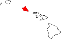
 Location in Honolulu County and the state of Hawaii | |
| Coordinates: 21°20′45″N 157°43′5″W / 21.34583°N 157.71806°WCoordinates: 21°20′45″N 157°43′5″W / 21.34583°N 157.71806°W | |
| Country |
|
| State |
|
| County |
|
| Area | |
| • Total | 4.4 sq mi (11.3 km2) |
| • Land | 4.4 sq mi (11.3 km2) |
| • Water | 0 sq mi (0 km2) |
| Elevation | 30 ft (9 m) |
| Population (2010) | |
| • Total | 5,451 |
| • Density | 1,200/sq mi (480/km2) |

Waimānalo is a census-designated place (CDP) in the City & County of Honolulu, in the District of Koʻolaupoko on the island of Oʻahu, Hawaii, United States. This small windward community is located near the eastern end of the island. In the Hawaiian language Waimānalo means "potable water"; it is so named for the many brackish ponds in the area that were used for irrigation. As of the 2010 Census, the CDP had a population of 5,451.[1]
Waimānalo is close to, but somewhat separated from, the neighborhood of Waimānalo Beach. Waimānalo has a small commercial center along Kalanianaʻole Highway, but is separated from the shoreline and Waimānalo Beach (the longest stretch of sandy shoreline on Oʻahu) by Bellows Air Force Station. Waimānalo is noteworthy for its local flavor and large agricultural lots in the valley that extend back towards the Koʻolau from the center of town. Numerous plant nurseries are found in this area. There are no hotels in Waimānalo.
Waimānalo is the site of Sea Life Park, located near Hawaiʻi Kai on Kalanianaole Highway. The U.S. postal code for Waimānalo is 96795.
Geography
Waimānalo is located at 21°20′45″N 157°43′5″W / 21.34583°N 157.71806°W. The nearest towns are Kailua to the west, and Waimānalo Beach to the east. According to the United States Census Bureau, the CDP has a total area of 4.4 square miles (11.3 km2), all of it land.[2]
Demographics
As of the census[3] of 2000, there were 3,664 people, 849 households, and 751 families residing in the CDP. The population density was 9,319.0 people per square mile (3,627.4/km²). There were 904 housing units at an average density of 2,299.2 per square mile (895.0/km²). The racial makeup of the CDP was 10.84% White, 0.16% Black or African American, 0.14% Native American, 26.80% Asian, 24.73% Pacific Islander, 0.33% from other races, and 37.01% from two or more races. 10.37% of the population were Hispanic or Latino of any race.
There are 849 households out of which 38.9% had children under the age of 18 living with them, 59.4% were married couples living together, 21.0% had a female householder with no husband present, and 11.5% were non-families. 8.5% of all households were made up of individuals and 3.3% had someone living alone who was 65 years of age or older. The average household size was 4.31 and the average family size is 4.42.
In the community the population was spread out with 31.4% under the age of 18, 10.7% from 18 to 24, 28.8% from 25 to 44, 20.7% from 45 to 64, and 8.4% who were 65 years of age or older. The median age was 30 years. For every 100 females there were 97.2 males. For every 100 females age 18 and over, there were 93.8 males.
The median income for a household in the CDP was $47,594, and the median income for a family was $43,347. Males had a median income of $28,036 versus $21,621 for females. The per capita income for the CDP was $12,493. 8.1% of the population and 5.9% of families were below the poverty line. Out of the total population, 9.6% of those under the age of 18 and 5.7% of those 65 and older were living below the poverty line.
Tourism
Waimanalo is the home of Sea Life Park, a marine biology and sea-life attraction located near Makapu'u Beach.[4][5] Japanese sumo grand champion, Chad Rowan (aka Akebono) was born in Waimanalo.[6] A large statue of Akebono stands at the Waimanalo Shopping Center and serves as a tourist photo opportunity.[7]
References
- ↑ "Profile of General Population and Housing Characteristics: 2010 Demographic Profile Data (DP-1): Waimanalo CDP, Hawaii". U.S. Census Bureau, American Factfinder. Retrieved May 31, 2012.
- ↑ "Geographic Identifiers: 2010 Demographic Profile Data (G001): Waimanalo CDP, Hawaii". U.S. Census Bureau, American Factfinder. Retrieved May 31, 2012.
- ↑ "American FactFinder". United States Census Bureau. Retrieved 2008-01-31.
- ↑ "Sea Life Park Hawaii, Marine Attraction, Oahu". Hawaiiweb.com. Retrieved 2015-10-15.
- ↑ Davis, Chelsea (2015-06-07). "Protesters rally against Sea Life Park Hawaii - Hawaii News Now - KGMB and KHNL". Hawaiinewsnow.com. Retrieved 2015-10-15.
- ↑ Panek, Mark (2006). Gaijin yokozuna : a biography of Chad Rowan. Honolulu, HI: University of Hawai'i Press. ISBN 9780824830434. OCLC 64289275. Retrieved 2015-10-15.
- ↑ "Six reasons to visit the Windward Oahu town of Waimanalo". Hawaiimagazine.com. Retrieved 2015-10-15.
External links
| Wikimedia Commons has media related to Waimānalo, Hawaii. |
- Waimānalo ahupuaʻa - non-commercial community site
- Sea Life Park Hawaii
Islands, municipalities, and communities of Honolulu County, Hawaii, United States | ||
|---|---|---|
| CDPs |
|  |
| Unincorporated communities | ||