Wadena, Minnesota
| Wadena, Minnesota | |
|---|---|
| City | |
 Location of the city of Wadena within Wadena County, Minnesota | |
| Coordinates: 46°26′22″N 95°8′14″W / 46.43944°N 95.13722°W | |
| Country | United States |
| State | Minnesota |
| Counties | Wadena, Otter Tail |
| Area[1] | |
| • Total | 5.38 sq mi (13.93 km2) |
| • Land | 5.38 sq mi (13.93 km2) |
| • Water | 0 sq mi (0 km2) |
| Elevation | 1,352 ft (412 m) |
| Population (2010)[2] | |
| • Total | 4,088 |
| • Estimate (2013[3]) | 4,133 |
| • Density | 759.9/sq mi (293.4/km2) |
| Time zone | Central (CST) (UTC-6) |
| • Summer (DST) | CDT (UTC-5) |
| ZIP code | 56482 |
| Area code(s) | 218 |
| FIPS code | 27-67504 |
| GNIS feature ID | 0653712[4] |
| Website | www.wadena.org |
Wadena (/wəˈdiːnə/ wə-DEEN-ə) is a city in Otter Tail and Wadena counties in the State of Minnesota. It is about one hundred sixty miles northwest of the Minneapolis – Saint Paul metro area. The population was 4,088 at the 2010 census.[5] It is the county seat of Wadena County.[6]
History
The first permanent settlement at Wadena was made in 1871.[7] The city is named after Chief Wadena, an Ojibwe Indian chief of the late 19th century in northwestern Minnesota.[8] A post office has been in operation at Wadena since 1873.[9] Wadena was incorporated in 1881.[7] Four properties in Wadena are listed on the National Register of Historic Places: the Commercial Hotel built circa 1885, the Wadena Fire and City Hall built in 1912, the Northern Pacific Passenger Depot built in 1915, and the Peterson-Biddick Seed and Feed Company built 1916–1936.[10]
2010 tornado

On June 17, 2010, Wadena was hit by an EF-4[11] tornado that cut a quarter-mile-wide path of destruction through the town. The Wadena tornado was part of the largest single day tornado outbreak in Minnesota state history, 48 tornados were recorded that day. The tornado that struck Wadena was over a mile wide at its peak, packed winds of up to 170 miles per hour, and was on the ground for about 10 miles.[11][12] At least 232 homes were damaged in the city accounting for roughly 30% of homes in the city. Though no one in the town was killed 34 people were treated for injuries at local hospitals.[13] The Community Center was damaged "beyond repair", and the high school was also severely damaged. Both were later torn down and rebuilt. The city continues to recover with roughly 20 lots abandoned throughout the city. City officials are encouraging rebuilding by offering tax free land incentives.[13] The Wadena Tornado was covered extensively on the December 1, 2010, episode of the Discovery Channel series Storm Chasers.
Geography
According to the United States Census Bureau, the city has a total area of 5.38 square miles (13.93 km2), all of it land.[1]
U.S. Highways 10 and 71 and Minnesota State Highway 29 are three of the main routes in the city.
Demographics
| Historical population | |||
|---|---|---|---|
| Census | Pop. | %± | |
| 1880 | 307 | — | |
| 1890 | 895 | 191.5% | |
| 1900 | 1,520 | 69.8% | |
| 1910 | 1,820 | 19.7% | |
| 1920 | 2,186 | 20.1% | |
| 1930 | 2,512 | 14.9% | |
| 1940 | 2,916 | 16.1% | |
| 1950 | 3,958 | 35.7% | |
| 1960 | 4,381 | 10.7% | |
| 1970 | 4,640 | 5.9% | |
| 1980 | 4,699 | 1.3% | |
| 1990 | 4,131 | −12.1% | |
| 2000 | 4,294 | 3.9% | |
| 2010 | 4,088 | −4.8% | |
| Est. 2015 | 4,176 | [14] | 2.2% |
| U.S. Decennial Census[15] 2013 Estimate[16] | |||
2010 census
As of the census[2] of 2010, there were 4,088 people, 1,840 households, and 1,013 families residing in the city. The population density was 759.9 inhabitants per square mile (293.4/km2). There were 2,010 housing units at an average density of 373.6 per square mile (144.2/km2). The racial makeup of the city was 95.6% White, 1.6% African American, 0.3% Native American, 0.4% Asian, 0.2% from other races, and 1.8% from two or more races. Hispanic or Latino of any race were 1.4% of the population.
There were 1,840 households of which 26.3% had children under the age of 18 living with them, 39.0% were married couples living together, 11.7% had a female householder with no husband present, 4.3% had a male householder with no wife present, and 44.9% were non-families. 40.2% of all households were made up of individuals and 20.1% had someone living alone who was 65 years of age or older. The average household size was 2.14 and the average family size was 2.86.
The median age in the city was 42 years. 22.1% of residents were under the age of 18; 9.5% were between the ages of 18 and 24; 21% were from 25 to 44; 24.3% were from 45 to 64; and 23% were 65 years of age or older. The gender makeup of the city was 47.3% male and 52.7% female.
2000 census
As of the census of 2000, there were 4,294 people, 1,871 households, and 1,062 families residing in the city. The population density was 818.4 people per square mile (315.8/km²). There were 1,964 housing units at an average density of 374.3 per square mile (144.4/km²). The racial makeup of the city was 97.88% White, 0.84% African American, 0.28% Native American, 0.19% Asian, 0.02% Pacific Islander, 0.16% from other races, and 0.63% from two or more races. Hispanic or Latino of any race were 0.61% of the population.
There were 1,871 households out of which 25.4% had children under the age of 18 living with them, 44.6% were married couples living together, 9.2% had a female householder with no husband present, and 43.2% were non-families. 37.8% of all households were made up of individuals and 20.3% had someone living alone who was 65 years of age or older. The average household size was 2.20 and the average family size was 2.92.
In the city the population was spread out with 23.4% under the age of 18, 10.2% from 18 to 24, 22.1% from 25 to 44, 20.2% from 45 to 64, and 24.1% who were 65 years of age or older. The median age was 41 years. For every 100 females there were 90.9 males. For every 100 females age 18 and over, there were 84.7 males.
The median income for a household in the city was $26,947, and the median income for a family was $39,511. Males had a median income of $28,286 versus $21,297 for females. The per capita income for the city was $15,452. About 10.3% of families and 15.6% of the population were below the poverty line, including 15.9% of those under age 18 and 13.4% of those age 65 or over.
Media
Radio stations
- FM radio
- AM radio
- 820 WBKK-AM
- 870 KPRM Classic Country
- 920 KWAD Classic Country
- 1070 KSKK Country
- 1430 KNSP Classic Country
- 1570 KAKK
Television
Wadena is served by five local TV stations:
- KVLY-TV Ch. 11 NBC (Fargo)
- KCCW Ch. 12 CBS (Walker)
- KVRR Ch. 15 FOX (Fargo)
- KAWB Ch. 22 PBS (Brainerd)
- KSAX Ch. 42 ABC (Alexandria)
The local cable TV provider is Arvig Communication Systems.
Newspapers
Arts and culture
With over 100 hand-painted murals decorating downtown buildings, Wadena depicts 1,000 years of Minnesota history known as the "Largest Puzzle in the World". The Alley Arts Committee beautified the alleys while creating an interesting tourist attraction. Over 40 artists worked together to finish the collection of 100 puzzle panels. Group guided tours are available along with a map at the train depot.[17]
During the 2015 Christmas season, Wisconsin-based group Freedom From Religion threatened legal action against the city of Wadena over the display of a city-owned nativity in a city park. To avoid a lawsuit, the city sold the nativity to a private buyer who was able to feature it in an even more prominent, privately owned location. As a result of the actions of the Freedom From Religion, many nativity scenes sprang up around the city, estimated to be over 1,000 in total. The former site of the city-owned nativity was rented out a day at a time by individuals who were legally able to display a nativity. The story captured the attention of national media outlets.[18]
References
- 1 2 "US Gazetteer files 2010". United States Census Bureau. Retrieved 2012-11-13.
- 1 2 "American FactFinder". United States Census Bureau. Retrieved 2012-11-13.
- ↑ "Population Estimates". United States Census Bureau. Retrieved 2014-06-09.
- ↑ "US Board on Geographic Names". United States Geological Survey. 2007-10-25. Retrieved 2008-01-31.
- ↑ "2010 Census Redistricting Data (Public Law 94-171) Summary File". American FactFinder. U.S. Census Bureau, 2010 Census. Retrieved April 23, 2011.
- ↑ "Find a County". National Association of Counties. Retrieved 2011-06-07.
- 1 2 Upham, Warren (1920). Minnesota Geographic Names: Their Origin and Historic Significance. Minnesota Historical Society. p. 562.
- ↑ "Wadena's Namesake". Wadena County Historical Society. Retrieved July 14, 2011.
- ↑ "Wadena County". Jim Forte Postal History. Retrieved 11 August 2015.
- ↑ National Park Service (2010-07-09). "National Register Information System". National Register of Historic Places. National Park Service.
- 1 2 McAuliffe, Bill (June 21, 2010). "Storms Packed Historic Strength". Star Tribune. Minneapolis. pp. A9. Retrieved June 21, 2010.
- ↑ "Tornadoes batter Wadena, Albert Lea area leaving behind major damage". KARE 11. June 18, 2010. Archived from the original on September 27, 2010. Retrieved 2010-09-27.
- 1 2 "Wadena A 'War Zone' After Thursday's Tornado". WCCO. June 18, 2010. Archived from the original on September 27, 2010. Retrieved 2010-09-27.
- ↑ "Annual Estimates of the Resident Population for Incorporated Places: April 1, 2010 to July 1, 2015". Retrieved July 2, 2016.
- ↑ United States Census Bureau. "Census of Population and Housing". Retrieved September 10, 2013.
- ↑ "Annual Estimates of the Resident Population: April 1, 2010 to July 1, 2013". Retrieved June 9, 2014.
- ↑ Murals of Minnesota
- ↑
External links
| Wikimedia Commons has media related to Wadena, Minnesota. |
Municipalities and communities of Otter Tail County, Minnesota, United States | ||
|---|---|---|
| Cities | 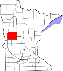 | |
| Townships |
| |
| Unincorporated communities | ||
| Indian reservation | ||
| Ghost towns | ||
| Footnotes | ‡This populated place also has portions in an adjacent county or counties | |
Municipalities and communities of Wadena County, Minnesota, United States | ||
|---|---|---|
| Cities |  | |
| Townships | ||
| Unincorporated communities | ||
| Ghost towns | ||
| Footnotes | ‡This populated place also has portions in an adjacent county or counties | |
Coordinates: 46°26′33″N 95°08′10″W / 46.44250°N 95.13611°W