Waddinxveen
| Waddinxveen | |||
|---|---|---|---|
| Municipality | |||
|
Vertical-lift bridge over the Gouwe in Waddinxveen | |||
| |||
.svg.png) Location in South Holland | |||
| Coordinates: 52°3′N 4°39′E / 52.050°N 4.650°ECoordinates: 52°3′N 4°39′E / 52.050°N 4.650°E | |||
| Country | Netherlands | ||
| Province | South Holland | ||
| Government[1] | |||
| • Body | Municipal council | ||
| • Mayor | Bert Cremers (PvdA) | ||
| Area[2] | |||
| • Total | 29.40 km2 (11.35 sq mi) | ||
| • Land | 27.90 km2 (10.77 sq mi) | ||
| • Water | 1.50 km2 (0.58 sq mi) | ||
| Elevation[3] | −2 m (−7 ft) | ||
| Population (May 2014)[4] | |||
| • Total | 25,555 | ||
| • Density | 916/km2 (2,370/sq mi) | ||
| Demonym(s) | Waddinxvener | ||
| Time zone | CET (UTC+1) | ||
| • Summer (DST) | CEST (UTC+2) | ||
| Postcode | 2740–2743 | ||
| Area code | 0182 | ||
| Website |
www | ||


Waddinxveen (Dutch pronunciation: [ˌʋɑdɪŋksˈfeːn]) is a town and municipality along the Gouwe river in the western Netherlands in the province of South Holland near Gouda. The municipality had a population of 25,555 in 2014 and covers an area of 29.40 km2 (11.35 sq mi) of which 1.50 km2 (0.58 sq mi) is water.
In Waddinxveen, there's the so-called 'Vergeten Plek' (Dutch for 'Forgotten Place'). This is the lowest place in the Dutch polders. It's 7.01 meters below Amsterdam Ordnance Datum.
Partner city of Waddinxveen is Pelhřimov in the Czech Republic.
History
The first reference to the area is from 1233, when on April 20, Floris IV, Count of Holland, sold an area of peat lands along the Gouwe River for 200 Dutch pounds to Nicolas of Gnepwijk, Lord of Aalsmeer and Woubrecht. The area was given the name "Waddinxvene". Because of this event, Waddinxveen celebrated its 750-year anniversary in 1983.
Between 1817 and 1870, Waddinxveen was dissolved and its area split into the municipalities of Noord-Waddinxveen and Zuid-Waddinxveen.[5] Due to further expanding, those two municipalities reunited into one.
Born in Waddinxveen
- Sharon den Adel (b. 1974) – vocalist of Within Temptation
- Mark van den Akker (b. 1966) (nl) – disc jockey at KXRadio
- Pepijn van den Nieuwendijk (b. 1970), painter and ceramist
- Hubert van Steel (b. 1856) – Dutch Grand Master[6]
- Robert Westerholt (b. 1975) – guitarist of Within Temptation
- Mark Vanderloo (b. 1968) - model
Gallery
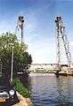 Lift bridge at Waddinxveen crossing the Gouwe.
 Bridge seen from the north side
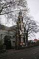 The Hefbrug church
References
- ↑ "Samenstelling college" [Members of the board] (in Dutch). Gemeente Waddinxveen. Retrieved 26 August 2013.
- ↑ "Kerncijfers wijken en buurten" [Key figures for neighbourhoods]. CBS Statline (in Dutch). CBS. 2 July 2013. Retrieved 12 March 2014.
- ↑ "Postcodetool for 2741HR". Actueel Hoogtebestand Nederland (in Dutch). Het Waterschapshuis. Retrieved 26 August 2013.
- ↑ "Bevolkingsontwikkeling; regio per maand" [Population growth; regions per month]. CBS Statline (in Dutch). CBS. 26 June 2014. Retrieved 24 July 2014.
- ↑ Ad van der Meer and Onno Boonstra, Repertorium van Nederlandse gemeenten, KNAW, 2006, p. 191 (Online edition)
- ↑ http://members.casema.nl/stamesko/dutchpainters.htm. Retrieved May 4, 2010. Missing or empty
|title=(help)
External links
 |
Alphen aan den Rijn | | ||
| |
Bodegraven-Reeuwijk | |||
| ||||
| | ||||
| Zuidplas | Gouda |
