Wacker Drive
 | |
| Former name(s) | Market Street |
|---|---|
| Length | 2.2 mi[1] (3.5 km) |
| South end |
Upper Wacker: Franklin Street / Harrison Street intersection (360 west at 424 south) |
| East end |
|
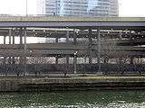
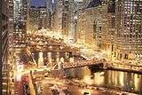
Wacker Drive is a major street in Chicago, Illinois, United States, running along the south side of the main branch and the east side of the south branch of the Chicago River. The street is a multilevel street that runs from 340 north at 400 east to 200 north at 340 west and along 360 west from 188 north to 424 south in the Chicago street address system in the Loop community area of Chicago.[2] The vast majority of it is double-decked; the upper level intended for local traffic, and the lower level for through-traffic and trucks servicing buildings on the road (and originally a dock). It is sometimes cited as a precursor to the modern freeway, though when it was built the idea was that pleasure vehicles would use the upper level. It is the only street in the city that has addresses on all four cardinal directions.
The upper level is normally known as Upper Wacker Drive and the lower level is Lower Wacker Drive. A short part has a third level, sometimes called Lower Lower Wacker Drive.[3]
History
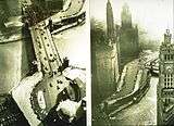
In 1909, architects Daniel Burnham and Edward H. Bennett drew up a plan for the Commercial Club of Chicago to unify the city's urban design and increase its physical beautification. The improvement of traffic flow in Chicago was a major part of the plan. Among its many recommendations was a double-decked roadway along the river, intended to relieve the congestion at River Street and Rush Street, where 50% of the city's north–south traffic crossed the Chicago River. Charles H. Wacker, chairman of the Chicago Plan Commission, pushed the idea.
The original double-decker road, replacing South Water and River Streets, was completed in 1926 at a cost of $8 million and named after Charles Wacker. The 1926 section stretched from Lake Street to Michigan Avenue, the latter of which was also rebuilt into a two-level road.
An extension south to Congress Parkway and Harrison Street was built between 1948 and 1954, replacing Market Street (after the Market Stub of the elevated Lake Street Line was removed).[4] Extensions east were built in 1963 and 1975, with the latter taking it to Lake Shore Drive, and a new lower level starting at Stetson Avenue. At the time, Lake Shore Drive had an S-curve at the river, running where Wacker now does between Field Boulevard and current Lake Shore Drive. This S-curve was on a viaduct over the Illinois Central Railroad's rail yard, and was at the level of Upper Wacker; the middle and lower levels dead-ended at that point. The current alignment of Lake Shore Drive was finished in 1986, and in 1987 Middle Wacker was extended to meet the new alignment. The ramps to bring upper traffic down had already been built; upper has been dead-ended where it used to end at Lake Shore Drive.

In 2001-2002, Wacker Drive was redesigned and reconstructed between Michigan Avenue and Randolph Street. The original upper deck was crumbling, and the entire roadway did not meet modern standards for road widths and clearances. Using a specially-developed "flat-slab, longitudinally post-tensioned, reinforced, high-performance concrete cast-in-place system", the new road deck was expected to have a lifespan of 75–100 years.[5] Walkways along the river were meant to make the drive more pedestrian-friendly, while restoration of historic limestone elements and reproduction lighting evoked the drive's original 1926 appearance. The 20-month, $200-million project was completed on time and within budget.[6]
In spring of 2010, work commenced on rebuilding the north-south section of Wacker, from Randolph Street to Congress Parkway, including the upper and lower levels. This is a continuation of the Revive Wacker Drive project started in 2001.
Wacker is the only street to intersect both State Street (the east–west center line) and Madison Street (the north–south center line), although Lake Shore Drive also crosses both dividing lines.
In April 2014, The American Council of Engineering Companies awarded the Wacker Drive and Congress Parkway Reconstruction project its Grand Conceptor Award. The project team was led by TranSystems and included roadway, bridge and tunnel improvement work. The project involved complex staging to keep 135,000 vehicles and 150,000 pedestrians moving through the construction zone each day. [7]
Intersections
The following streets intersect Wacker Drive, from south to north and west to east. Most upper-level streets that end at Wacker Drive, with only right turns allowed, are not included.
- Harrison Street at Franklin Street (one-way northbound) - beginning of Wacker Drive, before it splits into two levels; traffic from Harrison Street to the upper level must use Franklin Street to Congress Parkway
- Congress Parkway - ramps connect to both levels and from the lower level; a one-way westbound ramp connects Franklin Street to Upper Wacker
- Van Buren Street (one-way westbound) - upper
- Jackson Boulevard (one-way eastbound) - upper
- Adams Street (one-way westbound) - upper
- Monroe Street (one-way eastbound) - upper
- Madison Street (one-way westbound) - upper
- Washington Street (one-way eastbound) - upper
- Randolph Street (one-way westbound) - upper
- Lake Street (one-way eastbound to east) - upper
- Franklin Street (one-way northbound) - upper
- Post Place - lower
- Wells Street (one-way southbound) - upper
- LaSalle Street - upper
- Clark Street (one-way southbound) - upper
- Garvey Court - lower
- Dearborn Street (one-way northbound) - upper
- State Street - upper
- Wacker Place (one-way eastbound) - splits from eastbound lower and upper levels
- Wabash Avenue - upper
- Michigan Avenue - double-decker
- Beaubien Court - (only goes south) - lower
- Stetson Avenue (only goes south) - triple-decker (service level begins here)
- Columbus Drive - triple-decker to the south, lower to the north
- Field Boulevard (not built yet; former situs of Lake Shore Drive) - upper and service (which end here)
- Lake Shore Drive - lower
In popular media
The 1980 film The Blues Brothers used Wacker Drive as a setting.[8] The car chase scene in The Dark Knight (2008) was filmed on Lower Wacker Drive.[9]
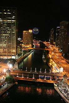
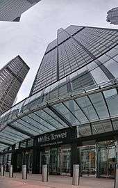
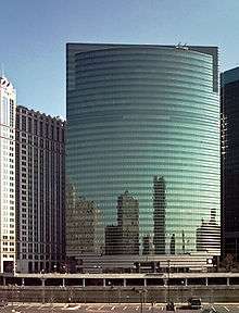
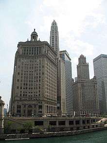
Gallery
|

.jpg)
See also
- Multilevel streets in Chicago
- Philo Carpenter
- Buildings on Wacker Drive
Notes
- ↑ Google Maps estimate.
- ↑ Hayner, Don and Tom McNamee, Streetwise Chicago, "Wacker Drive", p. 129., Loyola University Press, 1988, ISBN 0-8294-0597-6
- ↑ Brown, Mark. "Lower Wacker Homeless Coming to Uptown." Uptown Update. Web. Retrieved 7 Feb. 2012.
- ↑ Garfield, Graham. "Market Terminal". Chicago-L.org. Retrieved 2008-01-04.
- ↑ "Chicago Works to Revive Wacker Drive". Construction Writers Association. 2001-10. Retrieved 2008-01-04. Check date values in:
|date=(help) - ↑ "Revive Wacker Drive project". 2003. Retrieved 2008-01-04.
- ↑ "TranSystems - TranSystems' Wacker Drive Reconstruction Wins Top Honor from ACEC".
- ↑ "The Blues Brothers - Chicago Filming Locations". Locations in the Blues Brothers. Archived from the original on May 24, 2008. Retrieved December 16, 2008.
- ↑ "The Dark Knight (2008) - Filming Locations". IMDb.com, Inc. Retrieved 28 November 2016.
External links
Coordinates: 41°53′13″N 87°37′39″W / 41.88688°N 87.62738°W