Vlasotince
| Vlasotince Власотинце | ||
|---|---|---|
| Municipality and Town | ||
|
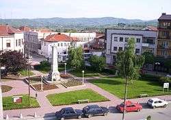
Vlasotince, town centre | ||
| ||
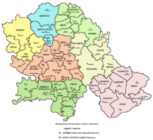
 Location of the municipality of Vlasotince within Serbia | ||
| Coordinates: 42°58′N 22°08′E / 42.967°N 22.133°ECoordinates: 42°58′N 22°08′E / 42.967°N 22.133°E | ||
| Country |
| |
| District | Jablanica | |
| Settlements | 48 | |
| Area[1] | ||
| • Municipality | 308 km2 (119 sq mi) | |
| Population (2011 census)[2] | ||
| • Town | 15,830 | |
| • Municipality | 29,669 | |
| Time zone | CET (UTC+1) | |
| • Summer (DST) | CEST (UTC+2) | |
| Postal code | 16210 | |
| Area code | +381 16 | |
| Car plates | VL | |

Vlasotince (Serbian Cyrillic: Власотинце) is a town and municipality in south-east Serbia. The municipality has 29,669 inhabitants, while the town itself has a population of 15,830 (2011 census).
History
According to Turkish records, the town existed in the 15th century as a Turkish administrative center. After the Turks were forced out of Serbia, locals started growing wine grapes as a kind of complementary business to their building activities. They made Vlasotince the number one wine region in the former Yugoslavia and furthermore the biggest wine exporter in the Balkans. The craftsmanship and building skills of workers and builders from this region were appreciated in the former Yugoslavia and its surrounding neighbours until the Yugoslav Wars.
Demographics
Ethnic groups in the municipality (2002 census):
- Serbs = 32,858
- Roma = 277
- others.
Settlements
Aside from the town of Vlasotince, the municipality includes the following settlements:
- Aleksine
- Batulovce
- Boljare
- Borin Dol
- Brezovica
- Crna Bara (Vlasotince)
- Crnatovo
- Gložane
- Gornja Lopušnja
- Gornja Lomnica
- Gornji Dejan
- Gornji Orah
- Gornji Prisjan
- Gradište
- Gunjetina
- Donje Gare
- Donji Dejan
- Donja Lopušnja
- Dobroviš
- Donja Lomnica
- Donji Prisjan
- Jastrebac
- Javorje
- Jakovljevo
- Komarica
- Konopnica
- Kozilo
- Kruševica
- Kukavica (Vlasotince)
- Ladovica
- Lipovica
- Orašje
- Prilepac
- Pržojne
- Ravna Gora (Vlasotince)
- Ravni Del
- Samarnica
- Šišava
- Skrapež
- Sredor
- Stajkovce
- Svođe
- Vlasotince
- Zlatićevo
Notable people
- Nenad Filipović, athletics
- Predrag Filipović, athletics
- Slaviša Stojanović, football coach
- Tihomir Stanojevic (first commander of police of Belgrade )
- Bogoljub Mitić, actor and comedian
See also
References
- ↑ "Municipalities of Serbia, 2006". Statistical Office of Serbia. Retrieved 2010-11-28.
- ↑ "2011 Census of Population, Households and Dwellings in the Republic of Serbia: Comparative Overview of the Number of Population in 1948, 1953, 1961, 1971, 1981, 1991, 2002 and 2011, Data by settlements" (PDF). Statistical Office of Republic Of Serbia, Belgrade. 2014. ISBN 978-86-6161-109-4. Retrieved 2014-06-27.
External links
| Wikimedia Commons has media related to Vlasotince. |
Capital: Vlasotince | ||
| Villages |
|  |
| Landmarks |
| |
| Culture |
| |
| Notable people |
| |