Vitrac, Dordogne
| Vitrac | ||
|---|---|---|
|
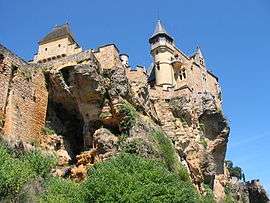
Chateau of Montfort | ||
| ||
 Vitrac | ||
|
Location within Nouvelle-Aquitaine region  Vitrac | ||
| Coordinates: 44°49′53″N 1°13′41″E / 44.8314°N 1.2281°ECoordinates: 44°49′53″N 1°13′41″E / 44.8314°N 1.2281°E | ||
| Country | France | |
| Region | Nouvelle-Aquitaine | |
| Department | Dordogne | |
| Arrondissement | Sarlat-la-Canéda | |
| Canton | Sarlat-la-Canéda | |
| Intercommunality | Périgord Noir | |
| Government | ||
| • Mayor (2008–2014) | Gérard Soulhié | |
| Area1 | 14.38 km2 (5.55 sq mi) | |
| Population (2008)2 | 853 | |
| • Density | 59/km2 (150/sq mi) | |
| Time zone | CET (UTC+1) | |
| • Summer (DST) | CEST (UTC+2) | |
| INSEE/Postal code | 24587 / 24200 | |
| Elevation |
60–243 m (197–797 ft) (avg. 140 m or 460 ft) | |
|
1 French Land Register data, which excludes lakes, ponds, glaciers > 1 km² (0.386 sq mi or 247 acres) and river estuaries. 2 Population without double counting: residents of multiple communes (e.g., students and military personnel) only counted once. | ||

Vitrac is a commune in the Dordogne department in Nouvelle-Aquitaine in southwestern France.
Population
| Historical population | ||
|---|---|---|
| Year | Pop. | ±% |
| 1962 | 570 | — |
| 1968 | 550 | −3.5% |
| 1975 | 622 | +13.1% |
| 1982 | 631 | +1.4% |
| 1990 | 743 | +17.7% |
| 1999 | 768 | +3.4% |
| 2008 | 853 | +11.1% |
See also
References
| Wikimedia Commons has media related to Vitrac (Dordogne). |
This article is issued from Wikipedia - version of the 11/9/2016. The text is available under the Creative Commons Attribution/Share Alike but additional terms may apply for the media files.