Visakhapatnam district
| Visakhapatnam district విశాఖపట్నం జిల్లా | |
|---|---|
| District of Andhra Pradesh | |
 Location of Visakhapatnam district in Andhra Pradesh | |
| Country | India |
| State | Andhra Pradesh |
| Headquarters | Visakhapatnam |
| Tehsils | 43[1] |
| Government | |
| • District collector | Praveen Kumar IAS[2] |
| • Lok Sabha constituencies | Araku (Lok Sabha constituency), Anakapalli, Visakhapatnam (Lok Sabha constituency) |
| • Assembly seats | 15 |
| Area | |
| • Total | 11,161 km2 (4,309 sq mi) |
| Population (2011) | |
| • Total | 4,288,113[3] |
| • Urban | 47.51% |
| Demographics | |
| • Literacy | 67.70% |
| • Sex ratio | 1003 |
| Vehicle registration | AP-11 |
| Major highways | NH-5 |
| Coordinates | 17°58′N 82°50′E / 17.967°N 82.833°ECoordinates: 17°58′N 82°50′E / 17.967°N 82.833°E |
| Website | [Visakhapatnam district website Official website] |
Visakhapatnam district is a district in the Indian state of Andhra Pradesh. It is one of the nine coastal districts in the state, with the administrative headquarters located at Visakhapatnam.[1]
History
Buddhist era
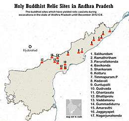
Visakhapatnam history goes back to the 6th century BCE. Its name can be found in Hindu and Buddhist texts that date back to ancient times. Vizag, as Visakhapatnam is often referred to, has been mentioned by Panini and Katyayana in their writings of the fourth century BC. The city was also a part of the Kalinga kingdom, which was later conquered by the emperor Ashoka. Visakha District is a large Buddhist remnants hub with many sites documented and undocumented from north to south border of the district along the coast line.
After independence
In 1979, part of the district was split to help form Vizianagaram district.[4] Visakhapatnam District is currently a part of the Red Corridor.[5]
Demographics

According to the 2011 census Visakhapatnam district has a population of 4,288,113[6] This gives it a ranking of 44th in India (out of a total of 640) and 4th in its state.[6] The district has a population density of 384 inhabitants per square kilometre (990/sq mi) .[6] Its population growth rate over the decade 2001-2011 was 11.89%.[6] Visakhapatnam has a sex ratio of 1003 females for every 1000 males,[6] and a literacy rate of 67.7%.[6]
Visakhapatnam district has a population of 4,288,113 people of which 57.95% is urban as of 2011 census.[7]
| Population | 4,288,113 |
| Males | 2,140,872 |
| Females | 2,147,241 |
| Growth(1991–2001) | 15.36% |
| Rural | 2250655 |
| Urban | 2037458 |
| Scheduled Caste Population | 291,219 (7.6%) |
| Scheduled Tribe population | 557,572 (14.55%) |
Geography
Visakhapatnam district occupies an area of approximately 11,161 square kilometres (4,309 sq mi),[8] comparatively equivalent to Canada's Cape Breton Island.[9]
Climate
| Climate data for Visakhapatnam | |||||||||||||
|---|---|---|---|---|---|---|---|---|---|---|---|---|---|
| Month | Jan | Feb | Mar | Apr | May | Jun | Jul | Aug | Sep | Oct | Nov | Dec | Year |
| Average high °C (°F) | 28.9 (84) |
31.3 (88.3) |
33.8 (92.8) |
35.3 (95.5) |
36.2 (97.2) |
35.3 (95.5) |
32.9 (91.2) |
32.7 (90.9) |
32.5 (90.5) |
31.7 (89.1) |
30.4 (86.7) |
28.9 (84) |
32.5 (90.5) |
| Average low °C (°F) | 18.0 (64.4) |
19.9 (67.8) |
23.0 (73.4) |
26.1 (79) |
27.7 (81.9) |
27.3 (81.1) |
26.1 (79) |
26.0 (78.8) |
25.6 (78.1) |
24.3 (75.7) |
21.6 (70.9) |
18.6 (65.5) |
23.7 (74.7) |
| Average precipitation mm (inches) | 11.4 (0.449) |
7.7 (0.303) |
7.5 (0.295) |
27.6 (1.087) |
57.8 (2.276) |
105.6 (4.157) |
134.6 (5.299) |
141.2 (5.559) |
174.8 (6.882) |
204.3 (8.043) |
65.3 (2.571) |
7.9 (0.311) |
945.7 (37.232) |
Economy
Visakhapatnam district is the central hub for industry and education in the state of Andhra Pradesh. Visakhapatnam district hosts the Vizag Steel Plant.
Household indicators
In 2007–2008, the International Institute for Population Sciences interviewed 1,233 households in 30 villages across the district.[10] They found that 82.1% had access to electricity, 73.9% had drinking water, 42.6% toilet facilities, and 43.8% lived in a pucca (permanent) home.[10] 22.6% of girls wed before the legal age of 18 and 73.8% of interviewees carried a BPL card.[10]
Divisions
The district has four revenue divisions, namely Anakapalli, Paderu, Narsipatnam and Visakhapatnam, each headed by a sub collector.[11] These revenue divisions are divided into 43 mandals in the district. These district consists of 3265 villages and 15 towns including, 1 municipal corporation, 2 municipalities and 12 census towns. Visakhapatnam city is the only municipal corporation and the 3 municipalities in the district are Anakapalle, Bheemunipatnam and Narsipatnam.[12] The 12 census towns are Bowluvada, Chodavaram, Chintapalle, Gudivada, Kantabamsuguda, Mulakuddu, Nakkapalle, Narsipatnam, Peda Boddepalle, Payakaraopeta, Upper Sileru Project Site Camp, Yelamanchili.[13]
Mandals

There are 10 mandals in Visakhapatnam division, 11 each in Narsipatnam, Anakapalle and Paderu divisions.[11][13] The 43 mandals under their revenue divisions are listed below:
Politics
There are three parliamentary and 15 assembly constituencies in Visakhapatnam district. The parliamentary constituencies are Anakapalli, Visakhapatnam and Araku. The assembly constituencies are[14] Anakapalle, Bhimli, Chodavaram, Yelamanchili, Madugula, Narsipatnam, Paderu, Pendurthi, Payakaraopet, Araku Valley, Visakhapatnam East, Visakhapatnam West, Visakhapatnam North, Visakhapatnam South and Gajuwaka.
Transport
The total of core road network of the district is 945.443 km (587.471 mi). It includes, 298.783 km (185.655 mi) of existing and a proposed length of 646.660 km (401.816 mi).[15]
Culture
Every December, from the third Friday to Sunday, an exclusive three-day festival brings to life the arts, crafts, culture and cuisine of Visakhapatnam.
Tourist spots


- Visakhapatnam is famous for its natural harbour, Ship building unit, Steel plant, Oil refineries, Dolphin's Nose Hills, and Ramakrishna beach. Rushikonda beach. It is industrial city in Andhra Pradesh.
- Bhimunipatnam is 40 km from Visakhapatnam and is famous for its natural sea port. Old Dutch Constructions and Buddhist Monastery Ruins.
- Simhachalam lies in the main city. It is famous for the Sri Varaha Narasimha Swami temple.
- Araku Valley is 112 km away from Visakhapatnam. It is famous for the scenic beauty it offers to the travellers by Train or Road. The area of the valley is roughly 36 km², and the altitude is between 600 and 900 meters above sea level. It is renowned for its association with the Tribal culture & customs.
- Thotlakonda lies to the north of Visakhapatnam which consists of a Buddhist Monastic Complex remnants and rock cut cisterns on the hilltop at Mangamaripeta.
- Bavikonda is another famous Hilltop Buddhist Monastic Complex remnant site near to Thotlakonda along the beach road to Bhimili from Vizag.
- Gudilova is famous for the temple of Lord shiva and Lord Ranganatha swamy located on a small hillock between two big hills in outskirts of Visakha city along the eastern Ghats, it is a natural picnic spot also. Located on the state highway of Pendurthi and 7 km from Anandapuram of Visakhapatnam
- The Borra Caves, also called Borra Guhalu (Telugu: బొర్రా గుహలు, in Telugu language ‘Borra’ means something that has bored into the ground and ‘guhalu’ means caves), are located on the East Coast of India, in the Ananthagiri hills of the Araku valley.
- The Kondakarla Ava, One of the largest freshwater lake in the country and cradled in the foothills of the Eastern Ghats,the lake Konda Karla-Ava is situated at 50 kilometres from Vizag on sankaram (Buddhist Place)- Etikoppaka (Craft Village)- Kondakarla Ava Circuit. Kondakarla Ava is the second largest fresh water lake in the state. It has been recognised as Eco-Tourism destination. Kondakarla Ava is home to an array of flora and fauna. As Soon as you enter Kondakarla Ava The scenic beauty takes you over. The tranquil waters of a lake surrounded by coconut trees on one side and green hills all around provide a great escape from the air and sound pollutions. It was a popular holiday resort of the Vizianagaram Maharajas and the British in the pre-independence era.
Education
The primary and secondary school education is imparted by government, aided and private schools, under the School Education Department of the state.[16][17] They include, 162 government, 2,793 mandal and zilla parishads, 9 residential, 1225 private, 5 model, 34 Kasturba Gandhi Balika Vidyalaya (KGBV), 147 municipal and 829 other types of schools.[18] The total number of students enrolled in primary, upper primary and high schools of the district are 609,587.[19]
References
- 1 2 "District - Visakhapatnam". Andhra Pradesh Online Portal. Retrieved 23 August 2014.
- ↑ "ALL INDIA SERVICES". Visakhapatnam District Official Website. NIC, Dept. of I.T., Ministry of C&I.T., Government of India. Retrieved 4 August 2014.
- ↑ "Visakhapatnam district profile". Andhra Pradesh State Portal.
- ↑ Law, Gwillim (25 September 2011). "Districts of India". Statoids. Retrieved 11 October 2011.
- ↑ "83 districts under the Security Related Expenditure Scheme". IntelliBriefs. 11 December 2009. Retrieved 17 September 2011.
- 1 2 3 4 5 6 "District Census 2011". Census2011.co.in. 2011. Retrieved 30 September 2011.
- ↑ http://www.ap.gov.in/districts/
- ↑ Srivastava, Dayawanti et al. (ed.) (2010). "States and Union Territories: Andhra Pradesh: Government". India 2010: A Reference Annual (54th ed.). New Delhi, India: Additional Director General, Publications Division, Ministry of Information and Broadcasting (India), Government of India. pp. 1111–1112. ISBN 978-81-230-1617-7.
- ↑ "Island Directory Tables: Islands by Land Area". United Nations Environment Program. 18 February 1998. Retrieved 11 October 2011.
Cape Breton Island 10,311km2
- 1 2 3 "District Level Household and Facility Survey (DLHS-3), 2007-08: India. Andhra Pradesh" (PDF). International Institute for Population Sciences and Ministry of Health and Family Welfare. 2010. Retrieved 3 October 2011.
- 1 2 "GO issued for creation of Anakapalle revenue division". The Hindu. Viskhapatnam. 4 April 2013. Retrieved 21 November 2015.
- ↑ "Adminsistrative divisions of Visakhapatnam district". Official Website of Visakhapatnam District. National Informatics Centre. Retrieved 16 January 2015.
- 1 2 "District Census Handbook - Visakhapatnam" (PDF). Census of India. pp. 26–27, 52. Archived from the original (PDF) on 19 November 2015. Retrieved 21 December 2015.
- ↑ "District-wise Assembly-Constituencies:". ceoandhra.nic.in.
- ↑ ":: APRDC ::". Andhra Pradesh Road Development Corporation. Roads and Buildings Department. Retrieved 9 November 2016.
- ↑ "School Education Department" (PDF). School Education Department, Government of Andhra Pradesh. Retrieved 7 November 2016.
- ↑ "The Department of School Education - Official AP State Government Portal". www.ap.gov.in. Retrieved 7 November 2016.
- ↑ "School Information Report". Commissionerate of School Education. Government of Andhra Pradesh. Retrieved 8 November 2016.
- ↑ "Student Information Report". Commissionerate of School Education. Child info 2015-16, District School Education - Andhra Pradesh. Retrieved 8 November 2016.
External links
| Wikimedia Commons has media related to Visakhapatnam district. |

| Topics |  | |
|---|---|---|
| Regions | ||
| Districts | ||
| Million-plus cities | ||
| Cities (population over 1 lakh) | ||
| Tourism |
| |
| Related lists |
| |
| ||