Viry-Châtillon
| Viry-Châtillon | ||
|---|---|---|
|
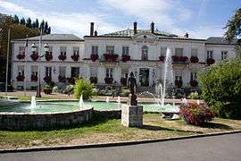
The town hall in Viry-Châtillon | ||
| ||
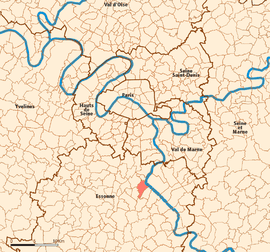 Location (in red) within Paris inner and outer suburbs | ||
| Coordinates: 48°40′17″N 2°22′30″E / 48.6713°N 2.375°ECoordinates: 48°40′17″N 2°22′30″E / 48.6713°N 2.375°E | ||
| Country | France | |
| Region | Île-de-France | |
| Department | Essonne | |
| Arrondissement | Évry | |
| Canton | Viry-Châtillon | |
| Intercommunality | Les Lacs de l'Essonne | |
| Government | ||
| • Mayor (2014–) | Jean-Marie Vilain (UDI) | |
| Area1 | 6.07 km2 (2.34 sq mi) | |
| Population (2006)2 | 31,600 | |
| • Density | 5,200/km2 (13,000/sq mi) | |
| Time zone | CET (UTC+1) | |
| • Summer (DST) | CEST (UTC+2) | |
| INSEE/Postal code | 91687 / 91170 | |
| Elevation | 32–84 m (105–276 ft) | |
|
1 French Land Register data, which excludes lakes, ponds, glaciers > 1 km² (0.386 sq mi or 247 acres) and river estuaries. 2 Population without double counting: residents of multiple communes (e.g., students and military personnel) only counted once. | ||
.svg.png)
Viry-Châtillon is a commune in the southern suburbs of Paris, France. It is located 20.9 km (13.0 mi) from the center of Paris.
Inhabitants of Viry-Châtillon are known as Castelvirois.
Twin towns
Transport
Viry-Châtillon is served by Viry-Châtillon station on Paris RER line D.
See also
References
- INSEE
- Mayors of Essonne Association (French)
External links
-
 Media related to Viry-Châtillon at Wikimedia Commons
 - Official website (French)
- Mérimée database – Cultural heritage (French)
- Land use (IAURIF) (English)
This article is issued from Wikipedia - version of the 8/19/2016. The text is available under the Creative Commons Attribution/Share Alike but additional terms may apply for the media files.