Virson
| Virson | |
|---|---|
|
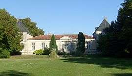
Chateau des Granges | |
 Virson | |
|
Location within Nouvelle-Aquitaine region  Virson | |
| Coordinates: 46°08′33″N 0°54′20″W / 46.1425°N 0.9055°WCoordinates: 46°08′33″N 0°54′20″W / 46.1425°N 0.9055°W | |
| Country | France |
| Region | Nouvelle-Aquitaine |
| Department | Charente-Maritime |
| Arrondissement | Rochefort |
| Canton | Aigrefeuille-d'Aunis |
| Government | |
| • Mayor (2008–2014) | Georges Delbecque |
| Area1 | 9.92 km2 (3.83 sq mi) |
| Population (2008)2 | 676 |
| • Density | 68/km2 (180/sq mi) |
| Time zone | CET (UTC+1) |
| • Summer (DST) | CEST (UTC+2) |
| INSEE/Postal code | 17480 / 17290 |
| Elevation |
6–36 m (20–118 ft) (avg. 20 m or 66 ft) |
|
1 French Land Register data, which excludes lakes, ponds, glaciers > 1 km² (0.386 sq mi or 247 acres) and river estuaries. 2 Population without double counting: residents of multiple communes (e.g., students and military personnel) only counted once. | |
Virson is a commune in the Charente-Maritime department in the Nouvelle-Aquitaine region in southwestern France. The Atlantic Ocean is situated to the west.
Population
| Historical population | ||
|---|---|---|
| Year | Pop. | ±% |
| 1962 | 274 | — |
| 1968 | 292 | +6.6% |
| 1975 | 285 | −2.4% |
| 1982 | 363 | +27.4% |
| 1990 | 387 | +6.6% |
| 1999 | 435 | +12.4% |
| 2008 | 676 | +55.4% |
See also
References
External links
| Wikimedia Commons has media related to Virson. |
This article is issued from Wikipedia - version of the 11/11/2016. The text is available under the Creative Commons Attribution/Share Alike but additional terms may apply for the media files.