Virginia State Route 316
| ||||
|---|---|---|---|---|
 | ||||
| Route information | ||||
| Maintained by VDOT | ||||
| Length: | 9.49 mi[1] (15.27 km) | |||
| Existed: | 1937 – present | |||
| Major junctions | ||||
| South end: |
| |||
|
| ||||
| North end: |
| |||
| Location | ||||
| Counties: | Accomack | |||
| Highway system | ||||
| ||||

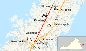
State Route 316 (SR 316) is a primary state highway in the U.S. state of Virginia. The state highway runs 9.49 miles (15.27 km) from U.S. Route 13 Business (US 13 Business) at Tasley north to SR 187 in Bloxom. SR 316 parallels the Bay Coast Railroad as it connects the central Accomack County towns of Accomac, Onley, and Onancock with the northern county towns of Parksley, Bloxom, and Hallwood.
Route description
SR 316 begins at a roundabout with US 13 Business and SR 126 in the hamlet of Tasley. US 13 Business heads east as Tasley Road toward Accomac and south toward Onley as Coastal Boulevard, both of which intersect US 13; SR 126 heads west as Fairgrounds Road toward Onancock. SR 316 heads north as Greenbush Road and begins to closely parallel the Bay Coast Railroad. The state highway passes through Greenbush and Chase Crossing before entering the town of Parksley as Cassatt Avenue. One block north of the town line, SR 316 intersects Bennett Street, which heads east as SR 176 and provides access to the Eastern Shore Railway Museum on the east side the railroad. The state highway leaves Parksley as Hopeton Road and passes through the village of Hopeton on its way to Bloxom. SR 316 enters the town as Bayside Drive and reaches its northern terminus at SR 187 (Shoremain Drive). Bayside Drive continues north as SR 779 toward the town of Hallwood.[1][2]
Major intersections
The entire route is in Accomack County.
| Location | mi[1] | km | Destinations | Notes | |
|---|---|---|---|---|---|
| Tasley | 0.00 | 0.00 | Roundabout | ||
| Parksley | 5.81 | 9.35 | |||
| Bloxom | 9.49 | 15.27 | |||
| 1.000 mi = 1.609 km; 1.000 km = 0.621 mi | |||||
References
- 1 2 3 "2010 Traffic Data". Virginia Department of Transportation. 2010. Retrieved 2012-01-11.
- Accomack County (PDF)
- ↑ Google (2012-01-11). "Virginia State Route 316" (Map). Google Maps. Google. Retrieved 2012-01-11.