Virajpet

| Virajpet ವಿರಾಜಪೇಟೆ Virajendrapete | |
|---|---|
| town | |
| Coordinates: 12°12′N 75°48′E / 12.2°N 75.8°ECoordinates: 12°12′N 75°48′E / 12.2°N 75.8°E | |
| Country |
|
| State | Karnataka |
| District | Kodagu |
| Elevation | 909 m (2,982 ft) |
| Population (2011) | |
| • Total | 17,246 |
| Languages | |
| • Official | Kannada, Kodava thakk |
| Time zone | IST (UTC+5:30) |
| PIN | 571 218 |
| Telephone code | 08274 |
| ISO 3166 code | IN-KL |
| Vehicle registration | KA-12 |
| Website | www.virajpettown.gov.in |
The town of Virajpet also spelled as Virajapete is the second town of the district of Kodagu, in Karnataka. It is the main town of the Virajpet taluka, in the south of the district. The name is an abbreviation of Virarajendrapete after the former ruler of Kodagu, Virarajendra, and this latter form is still sometimes used.
It is a small town of importance for the local coffee and spice crops. Nearby towns are Gonikoppal, Ammathi and Ponnampet. Virajpet is around 30 km away from Madikeri, the district headquarters and is about 250 km from Bangalore and 165 km from Mangalore. The only way to reach Virajpet is by road.
History
Named after the former ruler of Kodagu, Virarajendra, Virajpet is an abbreviation for Virarajendrapete. The history of the destination is rich as it was ruled by various South Indian dynasties. The Gangas, the Kadambas, the Chalukyas, the Cholas, the Hoysalas, the Rastrakutas and the Vijaynagar Rayas also ruled the region. After the end of the ruling period, the region was segmented into three major towns namely, Madikeri, Virajpet and Somwarpet.
About Virajpet Tourism
Virajpet town is situated in the Kodagu District of Karnataka. It is considered as the main town of Virajpet Taluka. Located at a distance of 30 km from the district headquarters Madikeri, it shares its geographical borders with the major towns of the district – Ammathi, Gonikoppal and Ponnampet.
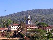
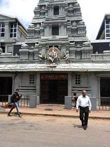
Some of the tourist attractions in and around Virajpet are the Ayyappa temple halfway up and the Shiva temple at the top of the Malethirike hill, a semispherical hill at Kakotuparambu which is about 8 km from Virajpet, St. Anne's church which is about 220 years old and has been built in Gothic architecture style. The tower of the church has two massive bells of the ancient times and are in use till date, the clock tower (pictured), Tadiandamol (the highest mountain in Kodagu) and the Igguthappa (local deity) temple, both in Kakkabe about 15 km from Virajpet.
The town is famous for its huge plantations of local coffee and spice crops. Virajpet is the largest honey producer in Asia. Ayyappa Temple and Shiva Temple on the top of Malethirike Hill, a semi-spherical hill at Kakotuparambu, are the prominent attractions that attract thousands of devotees.
Madikeri or Mercara Dasara is a prominent festival here, celebrated in the month of October. The celebration lasts for ten days along with cultural programmes depicting the victory of goddess of power over the asuras. A huge procession constituting singers, traditional dancers and music along with beautifully decorated ten tabloos is carried out. Virajpet can be visited in any season as the destination experiences pleasant climatic conditions throughout the year.
Demographics
As of the 2001 India census,[1] Virajpet had a population of 30000. Males constitute 51% of the population and females 49%. Virajpet has an average literacy rate of 81%, higher than the national average of 59.5%: male literacy is 83%, and female literacy is 78%. In Virajpet, 11% of the population is under 6 years of age. Most of the people are native Kodava speakers.
Places of worship
- Malethirke temple
- Pathyarakkara temple
- St.Anne's Church
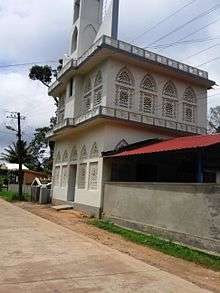
- Rahmaniya Mosque
Getting there
Virajpet is well connected with Mangalore, Mysore and Bangalore with road. Virajpet is also well connected by road with other places like Kannur, Thalassery, Iritty and Wayanad of neighbouring state Kerala.
The nearest railway stations are Thalassery and Kannur in Kerala, at a distance of 80 km each. Hassan and Mysore are other nearest Railway stations in Karnataka, at a distance of 138 km and 105 km respectively.
The nearest airports are Mysore Airport and Mangalore International Airport. Mysore Airport is at a distance of 115 km from Virajpet and Mangalore International Airport is at a distance of 172 km from Virajpet. Other major airports for Virajpet are Bangalore International Airport at a distance of 265 km and Kozhikkode International Airport at a distance of 176 km, which are much far from Virajpet. Kannur International Airport, under construction at Mattannur in Kerala is at a distance of 58 km from Virajpet.
See also
Gallery
-

Jain Street
-

St.Anne's Church
References
| Wikivoyage has a travel guide for Virajpet. |
- ↑ "Census of India 2001: Data from the 2001 Census, including cities, villages and towns (Provisional)". Census Commission of India. Archived from the original on 2004-06-16. Retrieved 2008-11-01.