Viola, Kansas
| Viola, Kansas | |
|---|---|
| City | |
|
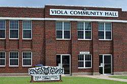
Former High School is now Community Center | |
 Location within Sedgwick County and Kansas | |
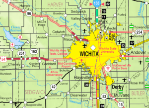 KDOT map of Sedgwick County (legend) | |
| Coordinates: 37°29′1″N 97°38′42″W / 37.48361°N 97.64500°WCoordinates: 37°29′1″N 97°38′42″W / 37.48361°N 97.64500°W | |
| Country | United States |
| State | Kansas |
| County | Sedgwick |
| Township | Viola |
| Area[1] | |
| • Total | 0.16 sq mi (0.41 km2) |
| • Land | 0.16 sq mi (0.41 km2) |
| • Water | 0 sq mi (0 km2) |
| Elevation | 1,342 ft (409 m) |
| Population (2010)[2] | |
| • Total | 130 |
| • Estimate (2015)[3] | 131 |
| • Density | 810/sq mi (320/km2) |
| Time zone | CST (UTC-6) |
| • Summer (DST) | CDT (UTC-5) |
| ZIP code | 67149 |
| Area code | 620 |
| FIPS code | 20-74025 |
| GNIS feature ID | 0470265 [4] |
Viola is a city in Sedgwick County, Kansas, United States. As of the 2010 census, the city population was 130.[5]
History
Viola had its start when the Englewood branch of the Santa Fe railroad was extended to that point.[6]
The first post office at Viola was established in 1877, but the post office was called Peotone until 1899.[7]
Geography
Viola is located at 37°29′1″N 97°38′42″W / 37.48361°N 97.64500°W (37.483526, -97.644918).[8] It is southwest of Wichita on Highway 42 at the intersection of Highway 49. According to the United States Census Bureau, the city has a total area of 0.16 square miles (0.41 km2), all of it land.[1]
Demographics
| Historical population | |||
|---|---|---|---|
| Census | Pop. | %± | |
| 1880 | 290 | — | |
| 1890 | 537 | 85.2% | |
| 1900 | 510 | −5.0% | |
| 1910 | 517 | 1.4% | |
| 1920 | 173 | −66.5% | |
| 1930 | 159 | −8.1% | |
| 1940 | 131 | −17.6% | |
| 1950 | 132 | 0.8% | |
| 1960 | 203 | 53.8% | |
| 1970 | 193 | −4.9% | |
| 1980 | 199 | 3.1% | |
| 1990 | 185 | −7.0% | |
| 2000 | 211 | 14.1% | |
| 2010 | 130 | −38.4% | |
| Est. 2015 | 131 | [3] | 0.8% |
| U.S. Decennial Census[9] 2012 Estimate[10] | |||
2010 census
As of the census[2] of 2010, there were 130 people, 51 households, and 37 families residing in the city. The population density was 812.5 inhabitants per square mile (313.7/km2). There were 64 housing units at an average density of 400.0 per square mile (154.4/km2). The racial makeup of the city was 91.5% White, 1.5% African American, 1.5% Native American, 1.5% from other races, and 3.8% from two or more races. Hispanic or Latino of any race were 8.5% of the population.
There were 51 households of which 37.3% had children under the age of 18 living with them, 66.7% were married couples living together, 5.9% had a female householder with no husband present, and 27.5% were non-families. 19.6% of all households were made up of individuals and 7.8% had someone living alone who was 65 years of age or older. The average household size was 2.55 and the average family size was 2.89.
The median age in the city was 38.7 years. 23.8% of residents were under the age of 18; 10% were between the ages of 18 and 24; 21.5% were from 25 to 44; 26.8% were from 45 to 64; and 17.7% were 65 years of age or older. The gender makeup of the city was 50.8% male and 49.2% female.
2000 census
As of the census of 2000, there were 211 people, 74 households, and 56 families residing in the city. The population density was 1,331.7 people per square mile (509.2/km²). There were 79 housing units at an average density of 498.6 per square mile (190.6/km²). The racial makeup of the city was 96.21% White, 2.37% Native American, 0.47% from other races, and 0.95% from two or more races. Hispanic or Latino of any race were 1.42% of the population.
There were 74 households out of which 41.9% had children under the age of 18 living with them, 55.4% were married couples living together, 14.9% had a female householder with no husband present, and 24.3% were non-families. 21.6% of all households were made up of individuals and 8.1% had someone living alone who was 65 years of age or older. The average household size was 2.85 and the average family size was 3.25.
In the city the population was spread out with 36.0% under the age of 18, 8.1% from 18 to 24, 25.6% from 25 to 44, 19.9% from 45 to 64, and 10.4% who were 65 years of age or older. The median age was 32 years. For every 100 females there were 99.1 males. For every 100 females age 18 and over, there were 101.5 males.
The median income for a household in the city was $45,469, and the median income for a family was $47,031. Males had a median income of $42,000 versus $20,625 for females. The per capita income for the city was $16,804. About 3.4% of families and 7.9% of the population were below the poverty line, including 15.4% of those under the age of eighteen and none of those sixty five or over.
See also
References
- 1 2 "US Gazetteer files 2010". United States Census Bureau. Retrieved 2012-07-06.
- 1 2 "American FactFinder". United States Census Bureau. Retrieved 2012-07-06.
- 1 2 "Annual Estimates of the Resident Population for Incorporated Places: April 1, 2010 to July 1, 2015". Retrieved July 2, 2016.
- ↑ "US Board on Geographic Names". United States Geological Survey. 2007-10-25. Retrieved 2008-01-31.
- ↑ "2010 City Population and Housing Occupancy Status". U.S. Census Bureau. Retrieved March 6, 2011.
- ↑ Bentley, Orsemus Hills (1910). History of Wichita and Sedgwick County, Kansas: Past and Present. Windmill Publications. p. 644.
- ↑ "Kansas Post Offices, 1828-1961, page 2". Kansas Historical Society. Retrieved 23 June 2014.
- ↑ "US Gazetteer files: 2010, 2000, and 1990". United States Census Bureau. 2011-02-12. Retrieved 2011-04-23.
- ↑ United States Census Bureau. "Census of Population and Housing". Retrieved October 24, 2013.
- ↑ "Annual Estimates of the Resident Population: April 1, 2010 to July 1, 2012". Retrieved October 24, 2013.
External links
| Wikimedia Commons has media related to Viola, Kansas. |
- City
- Schools
- USD 356, local school district
- Maps
- Viola City Map, KDOT
Municipalities and communities of Sedgwick County, Kansas, United States | ||
|---|---|---|
| Cities |  | |
| CDPs | ||
| Unincorporated communities | ||
| Townships | ||
| Footnotes | ‡This populated place also has portions in an adjacent county or counties | |