Vinalhaven, Maine
Coordinates: 44°02′53″N 68°49′54″W / 44.04806°N 68.83167°W
| Vinalhaven, Maine | |
|---|---|
| Town | |
|
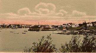
Main Street c. 1915 | |
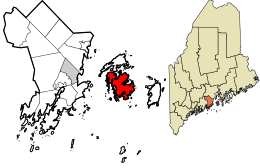 Location in Knox County and the state of Maine. | |
| Coordinates: 44°3′31″N 68°51′4″W / 44.05861°N 68.85111°W | |
| Country | United States |
| State | Maine |
| County | Knox |
| Incorporated | 1789 |
| Area[1] | |
| • Total | 168.69 sq mi (436.91 km2) |
| • Land | 23.46 sq mi (60.76 km2) |
| • Water | 145.23 sq mi (376.14 km2) |
| Elevation | 39 ft (12 m) |
| Population (2010)[2] | |
| • Total | 1,165 |
| • Estimate (2012[3]) | 1,153 |
| • Density | 49.7/sq mi (19.2/km2) |
| Time zone | Eastern (EST) (UTC-5) |
| • Summer (DST) | EDT (UTC-4) |
| ZIP code | 04863 |
| Area code(s) | 207 |
| FIPS code | 23-79130 |
| GNIS feature ID | 0582782 |

Vinalhaven is a town located on the larger of the two Fox Islands in Knox County, Maine, United States. Vinalhaven is also used to refer to the Island itself. The population was 1,165 at the 2010 census. It is home to a thriving lobster fishery and hosts a summer colony. Since there is no bridge to the island, Vinalhaven is accessible from Rockland via an approximately hour-and-fifteen-minute ferry ride across West Penobscot Bay, or by air taxi from Knox County Regional Airport.
History

Archeological remains indicate that the island was first inhabited 3800–5000 years ago by the Red Paint People. Later, it became Abenaki territory. Europeans visited in the 16th century, and English Capt. Martin Pring named the archipelago Fox Islands in 1603. The first permanent English settlement occurred in 1766 when Thaddeus Carver from Marshfield, Massachusetts, arrived, and later purchased 700 acres (2.8 km2) from Thomas Cogswell on the southern shore near what would become known as Carver's Harbor.[4]
Others soon followed to establish the remote fishing and farming community in the Gulf of Maine. The first families of Vinalhaven are considered to be Arey, Calderwood, Carver, Coombs, Dyer, Ginn, Greem, Hopkins, Lane, Leadbetter, Norton, Philbrook, Pierce, Roberts, Smith, Warren and Vinal. On June 25, 1789, Vinalhaven was incorporated as a town, named for John Vinal.[5] Vinal was not an island resident, merely the agent who petitioned the Maine General Court to incorporate the new township; nonetheless the name stuck.[6] In 1847, the North Fox Island seceded and became a separate township called North Haven.[7]

Fishing, shipbuilding, logging and shipping were important early businesses on Vinalhaven. High quality granite was discovered in 1826, and Vinalhaven became one of Maine's largest quarrying centers for the next century. Today the island is dotted with abandoned old quarries, many of which have since filled with groundwater and are popular swimming holes for residents and visitors alike. Pinkish-gray Vinalhaven granite, excavated by the Bodwell Granite Company, can be seen in the State Department Building in Washington, New York City's Brooklyn Bridge, and the Union Mutual Life Insurance Building in Boston.[8]
Granite was shipped for customs houses and post offices in New York; St. Louis; Kansas City; Buffalo, etc.; the railroad station and the Board of Trade in Chicago; the Washington Monument and federal office buildings in the Capital; the Pennsylvania Railroad Station and the Masonic Temple in Philadelphia; as well as private mansions, monuments, bridges, dams, and thousands of tons of paving blocks for the streets of Portland; Boston; New York; Newark; Philadelphia and other cities.[9] The Vinalhaven quarries were the only ones deep enough to provide the eight huge polished columns called for in the original plans for the apse of the Cathedral of Saint John the Divine in New York City; unfortunately the massive columns broke under their own weight, and ultimately more than one piece of granite had to be put together to create each column.[10] The quarries also provided foundation stone for the cathedral.
A noted lobster fishing community, Vinalhaven has fishing rights to much of Penobscot Bay and its offshore waters. There are ten major fishing grounds around Vinalhaven that the island's fishermen and some Matinicus Isle fishermen have used for centuries to capture such groundfish as cod, haddock, pollock, hake, lobster scallops and halibut. Shrimp, dogfish, mackerel and herring are also abundant in the waters around Vinalhaven. Vinalhaven lobstermen were the first in the nation to unionize. They began to organize in the winter of 2012-13, after frustration with low lobster prices being to paid to them and disagreements with the Maine Lobstermen's Associations leadership.[11]
Like neighboring North Haven Island, Vinalhaven is well known for its summer community of wealthy Northeasterners, mostly from Boston, New York, and Philadelphia. The movie The Islander was filmed on Vinalhaven and some of the locals acted in the movie.[9]
Geography
According to the United States Census Bureau, the town has a total area of 168.69 square miles (436.91 km2), of which, 23.46 square miles (60.76 km2) of it is land and 145.23 square miles (376.14 km2) is water.[1]
Demographics
| Historical population | |||
|---|---|---|---|
| Census | Pop. | %± | |
| 1790 | 578 | — | |
| 1800 | 858 | 48.4% | |
| 1810 | 1,052 | 22.6% | |
| 1820 | 1,308 | 24.3% | |
| 1830 | 1,794 | 37.2% | |
| 1840 | 1,950 | 8.7% | |
| 1850 | 1,252 | −35.8% | |
| 1860 | 1,667 | 33.1% | |
| 1870 | 1,851 | 11.0% | |
| 1880 | 2,855 | 54.2% | |
| 1890 | 2,617 | −8.3% | |
| 1900 | 2,358 | −9.9% | |
| 1910 | 2,344 | −0.6% | |
| 1920 | 1,965 | −16.2% | |
| 1930 | 1,843 | −6.2% | |
| 1940 | 1,629 | −11.6% | |
| 1950 | 1,427 | −12.4% | |
| 1960 | 1,273 | −10.8% | |
| 1970 | 1,135 | −10.8% | |
| 1980 | 1,211 | 6.7% | |
| 1990 | 1,072 | −11.5% | |
| 2000 | 1,235 | 15.2% | |
| 2010 | 1,165 | −5.7% | |
| Est. 2014 | 1,144 | [12] | −1.8% |
2010 census
As of the census[2] of 2010, there were 1,165 people, 545 households, and 320 families residing in the town. The population density was 49.7 inhabitants per square mile (19.2/km2). There were 1,295 housing units at an average density of 55.2 per square mile (21.3/km2). The racial makeup of the town was 97.6% White, 0.1% African American, 0.3% Native American, 0.3% Asian, 0.2% from other races, and 1.6% from two or more races. Hispanic or Latino of any race were 0.2% of the population.
There were 545 households of which 24.2% had children under the age of 18 living with them, 46.2% were married couples living together, 7.5% had a female householder with no husband present, 5.0% had a male householder with no wife present, and 41.3% were non-families. 34.5% of all households were made up of individuals and 13.4% had someone living alone who was 65 years of age or older. The average household size was 2.14 and the average family size was 2.70.
The median age in the town was 45.1 years. 19.5% of residents were under the age of 18; 7% were between the ages of 18 and 24; 23.4% were from 25 to 44; 33.6% were from 45 to 64; and 16.7% were 65 years of age or older. The gender makeup of the town was 51.2% male and 48.8% female.
2000 census
As of the census[14] of 2000, there were 1,235 people, 550 households, and 341 families residing in the town. The population density was 48.8 people per square mile (18.8/km²). There were 1,228 housing units at an average density of 48.5 per square mile (18.7/km²). The racial makeup of the town was 98.14% White, 0.32% Native American, 0.32% Asian, and 1.21% from two or more races.

There were 550 households, out of which 29.3% had children under the age of 18 living with them, 49.6% were married couples living together, 7.5% had a female householder with no husband present, and 38.0% were non-families. 32.5% of all households were made up of individuals and 15.3% had someone living alone who was 65 years of age or older. The average household size was 2.25 and the average family size was 2.82. Lobstering is a considerable part of the island's economy. Almost everyone lobsters.
In the town the population was spread out with 23.7% under the age of 18; 6.4% from 18 to 24; 27.8% from 25 to 44; 23.6% from 45 to 64; and 18.5% who were 65 years of age or older. The median age was 40. For every 100 females, there were 92.1 males. For every 100 females age 18 and over, there were 91.1 males.
The median income for a household in the town was $34,087, and the median income for a family was $42,917. Males had a median income of $36,094 versus $17,750 for females. The per capita income for the town was $21,287. About 5.7% of families and 9.0% of the population were below the poverty line, including 7.1% of those under age 18 and 8.6% of those age 65 or over.
Energy
Vinalhaven is the site of one of the first large wind power projects on the east coast of the United States. Approved by a vote of 383–5 on July 29, 2008, by members of the Fox Islands Electric Cooperative, the project was expected to significantly reduce rates on the island residents, who previously imported their power from the mainland via a submarine power cable.[15][16] Three 1.5 MW wind turbine towers, which went online in late 2009, are capable of producing a comparable amount of energy to what the island uses.
Near the end of 2009, an Island Energy Task Force was established in order to "facilitate a transition to affordable, reliable, domestically produced energy, and on the consumer end, to energy-smart products, with special emphasis on serving the Vinalhaven community."
Starting in the spring of 2010, the task force began spearheading a project to use some of the Fox Islands wind energy to charge electric thermal storage heaters installed on the island. The charging takes place when the project's three turbines are generating more power than the islands need, which is common in the winter. [17]
In operation the turbines have indeed reduced power bills, but at a cost of a loss of quality of life for nearby residents, who complain that the turbines cause constant noise and vibration.[18]
Education
- Vinalhaven School is the town's K–12 public school.
- The ARC is Vinalhaven's nonprofit hands-on vocational learning center.[19]
Sites of interest
- Browns Head Light[20]
- Heron Neck Light[21]
- Lane's Island[22]
- Saddleback Ledge Light[23]
- Vinalhaven Historical Society & Museum[24]
Properties in Vinalhaven listed on the National Register of Historic Places include: Browns Head Light, Heron Neck Light, Murch Family House, Pleasant River Grange No. 492, Saddleback Ledge Light, Star of Hope Lodge, Union Church of Vinalhaven, Vinalhaven Public Library and the Moses Webster House.
Notable people
- Margaret Wise Brown, children's book author
- Caitlin Cahow, hockey player
- Joseph P. Dyer, politician
- Gerald Edelman, scientist (Nobel Prize, 1972)
- John C. Harkness, architect
- Leonard Hokanson, concert pianist
- Robert Indiana, artist associated with the Pop Culture Movement
- John Jay Iselin, administrator, educator
- Philip Jamison, artist
- Brewster Jennings, industrialist
- Bill Murray, professional baseball player
- Leverett Saltonstall, 55th governor of Massachusetts
- Ketch Secor, musician with the Old Crow Medicine Show
- John Wulp, scenic designer, producer, director
See also
References
Notes
- 1 2 "US Gazetteer files 2010". United States Census Bureau. Retrieved 2012-12-16.
- 1 2 "American FactFinder". United States Census Bureau. Retrieved 2012-12-16.
- ↑ "Population Estimates". United States Census Bureau. Retrieved 2013-07-06.
- ↑ Coolidge, Austin J.; John B. Mansfield (1859). A History and Description of New England. Boston, Massachusetts. p. 334.
- ↑ "Profile for Vinalhaven, Maine". ePodunk. Retrieved 2010-05-03.
- ↑ Mclane, Charles; Carol Evarts McLane (1997). Islands of the Mid-Maine Coast. I. Tilbury House; Island Institute. p. 125. ISBN 0884481859.
- ↑ Varney, George J. (1886). "History of Vinalhaven, Maine". Gazetteer of the State of Maine. Boston: B. B. Russell.
- ↑ "The Story of Vinalhaven's Granite Industry".
- 1 2 "A History of Vinalhaven", The Vinalhaven Historical Society, August 1995.
- ↑ Nevius, Michelle & Nevius, James (2009), Inside the Apple: A Streetwise History of New York City, New York: Free Press, ISBN 141658997X, p.166
- ↑ Curtis, Abigail (March 15, 2013). "Growing number of lobstermen looking to unionize, gain voice in Augusta". Bangor Daily News. Retrieved 2013-04-07.
- ↑ "Annual Estimates of the Resident Population for Incorporated Places: April 1, 2010 to July 1, 2014". Retrieved June 4, 2015.
- ↑ "Census of Population and Housing". Census.gov. Retrieved June 4, 2015.
- ↑ "American FactFinder". United States Census Bureau. Retrieved 2008-01-31.
- ↑ "Fox Islands Electric Wind Power Project". Fox Islands Electric. Retrieved 2009-06-05.
- ↑ Conkling, Micah (June 2009). "Construction to start on Fox Islands wind project". The Working Waterfront. Retrieved 2009-06-05.
- ↑ "Excess Wind Power Finds Home on Maine Islands". Portland Press Herald. 2010-04-04. Retrieved 2010-04-08.
- ↑ Zeller, Tom "For Those Near, the Miserable Hum of Clean Energy" New York Times (October 5, 2010)
- ↑ "About Us". The Arts & Recreation Center. Retrieved 10 May 2012.
- ↑ D'Entremont, Jeremy. "Brown's Head Light". New England Lighthouses: A Virtual Guide. Retrieved 10 May 2012.
- ↑ D'Entremont, Jeremy. "Heron Neck Light". New England Lighthouses: A Virtual Guide. Retrieved 10 May 2012.
- ↑ "Miane: Lane's Island". The Nature Conservancy. Retrieved 10 May 2012.
- ↑ D'Entremont, Jeremy. "Saddleback Ledge Light". New England Lighthouses: A Virtual Guide. Retrieved 10 May 2012.
- ↑ "Vinalhaven Historical Society (homepage)". Retrieved 10 May 2012.
External links
| Wikimedia Commons has media related to Vinalhaven, Maine. |
| Wikivoyage has a travel guide for Vinalhaven. |
- Town of Vinalhaven, Maine
- Vinalhaven Public Library
- Vinalhaven School
- Vinalhaven Chamber Of Commerce
- Maine.gov -- Vinalhaven, Maine
- Vinalhaven, Maine, stone quarry info. on Stone Quarries and Beyond
- Monuments of Stone, Testaments to an Island -- The New York Times
- Maine Genealogy: Vinalhaven, Knox County, Maine
Municipalities and communities of Knox County, Maine, United States | ||
|---|---|---|
| City |  | |
| Towns | ||
| Plantation | ||
| Unorganized territory | ||
| CDPs | ||
| Other villages | ||