Vilnius County
| Vilnius County Vilniaus apskritis | |||
|---|---|---|---|
| County | |||
 | |||
| |||
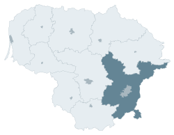 Location of Vilnius County | |||
| Country |
| ||
| Administrative centre | Vilnius | ||
| Municipalities | |||
| Area | |||
| • Total | 9,731 km2 (3,757 sq mi) | ||
| (14.9% of the area of Lithuania) | |||
| Population (2015) | |||
| • Total | 805,142 () | ||
| • Rank | 1st of 10 (27% of the population of Lithuania) | ||
| Time zone | EET (UTC+2) | ||
| • Summer (DST) | EEST (UTC+3) | ||
| ISO 3166 code | LT-VL | ||
| GDP(nominal) | 2014 | ||
| - Total | €14.6($20) billion | ||
| - Per capita | €18,100($24,000)() | ||

Vilnius County (Lithuanian: Vilniaus apskritis) is the largest of the 10 counties of Lithuania, located in the east of the country around the city Vilnius. On 1 July 2010, the county administration was abolished,[1] and since that date, Vilnius County remains as the territorial and statistical unit.
History
Until the Partitions of the Polish–Lithuanian Commonwealth in late 18th century the area belonged to the Vilnius Voivodship and Trakai Voivodship of the Polish-Lithuanian Commonwealth. In Russian Empire it belonged to the Northwestern Krai and approximately corresponded to its Vilna Governorate (as of 1843). During World War I, following the German offensive of 1915, it was occupied by the German army. After the war, some parts of the area was ruled by local Polish self-government established after the German Ober-Ost army withdrew from the area.
Following the start of the Polish-Bolshevik War in 1919, it was occupied by the Red Army, which was pushed back by the Polish Army. In 1920, it was again occupied by the Red Army, but Soviets officially recognized the sovereignty of Lithuanian Republic over the city immediately after defeat during Battle of Warsaw. During their retreat, the Bolsheviks passed the sovereignty over the area to Lithuania. The Polish commander Józef Piłsudski ordered his subordinate general Lucjan Żeligowski to "rebel" his Lithuanian-Belarusian division and capture the city of Vilnius, without declaring war on Lithuania. The area of the future Vilnius County was seized by the Polish forces without significant opposition from Lithuanian forces and Gen. Żeligowski created a short-lived state called Republic of Central Lithuania. Following the elections held there in 1922 the state was incorporated into Poland (see Vilnius region, Central Lithuania).
In the effect of the Nazi-Soviet Alliance and the Polish Defensive War of 1939, the area was captured by the Soviet Union, which transferred parts of present Vilnius County and Utena County to Lithuania, only to annex it the following year. In 1941, it was conquered by the Nazi Germany. During World War II, the area saw formation of many resistance units, most notably the Polish Home Army and, after 1943, the Soviet partisans. After the war, Vilniaus Apskritis existed as a relic of the pre-war independent state in Lithuanian SSR between 1944 and 1950. In this period, significant part of its population moved to Poland during so-called repatriation.
After 1990 saw the emergence of independent Lithuania, Vilnius county was re-established differently in 1994. This entity has different boundaries than any previous entity and is not directly related to previous entities in this area. The mission of the county is different as well: its primary goal (as in that of Lithuania's other counties) is to oversee that municipalities in its area follow the laws of Lithuania.
Municipalities
The county is subdivided into 6 district municipalities, 1 municipality and 1 city municipality:
- Elektrėnai Municipality
- Šalčininkai District Municipality
- Širvintos District Municipality
- Švenčionys District Municipality
- Trakai District Municipality
- Ukmergė District Municipality
- Vilnius City Municipality
- Vilnius District Municipality
Economy
Nominal GDP per capita of Vilnius County was about €18,100($24,000)[2] as of 2014, making it the richest county in the Republic of Lithuania. The average monthly wage after tax in Vilnius County was about $700[3] as of 2015. Vilnius County creates about 2/5 of Lithuania's and 1/5 of Baltic States Nominal GDP.
References
- ↑ "Dėl apskričių viršininkų administracijų likvidavimo". Seimas of the Republic of Lithuania. Retrieved 21 August 2011.
- ↑ http://osp.stat.gov.lt/statistiniu-rodikliu-analize?id=8446&status=A
- ↑ https://osp.stat.gov.lt/informaciniai-pranesimai?eventId=61871
External links
- Social and demographic characteristics of Vilnius County
- Economy of Vilnius County
- Environment of Vilnius County
| Municipalities |  | |
|---|---|---|
| Cities | ||
| Towns | ||
| Villages | ||
Coordinates: 54°40′49″N 25°17′02″E / 54.68028°N 25.28389°E