Las Villuercas
| Las Villuercas | |
|---|---|
| Comarca | |
|
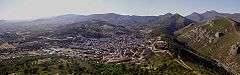
Sierra de las Villuercas mountains. | |
 Las Villuercas; location in Cáceres Province | |
| Country |
|
| Autonomous community | Extremadura |
| Province | Cáceres |
| Capital | Guadalupe |
| Municipalities |
List
|
| Area | |
| • Total | 1,545.5 km2 (596.7 sq mi) |
| Elevation | 570 m (1,870 ft) |
| Population | |
| • Total | 9,045 |
| • Density | 5.9/km2 (15/sq mi) |
| Time zone | CET (UTC+1) |
| • Summer (DST) | CEST (UTC+2) |

Typical landscape of Las Villuercas in Cañamero.
Las Villuercas is a comarca located in the province of Cáceres, western Spain. It belongs to the Autonomous Community of Extremadura.
Despite of the traditional strong identity of its inhabitants, this historical region has not been able to achieve the necessary legal recognition for its administrative development. The comarca has a total of about 9,000 inhabitants.
Its geography is typical of the Meseta Central. The Sierra de Villuercas, also known as Sierra de Guadalupe is part of this comarca.[1]
The comarca is named after La Villuerca, the highest peak in the range and also the highest point of the greater Montes de Toledo system, an ancient name that has been documented since 1353.[2]
Municipalities
- Alía
- Cíjara
- Puerto Rey
- La Calera
- Berzocana
- Cabañas del Castillo
- Solana de Cabañas
- Retamosa de Cabañas
- Roturas de Cabañas
- Cañamero
- Guadalupe
- Logrosán
- Navezuelas
- Robledollano
References
- ↑ Julio Muñoz Jiménez, Los Montes de Toledo. Estudios de Geografía Física. Departamento de Geografía de la Universidad de Oviedo. Instituto J. S. Elcano (CSIC), Oviedo 1976
- ↑ El topónimo Villuercas
External links
| Wikimedia Commons has media related to Las Villuercas. |
- Las Villuercas
- Guidebook to Las Villuercas - Ibores (Spanish)
- Birdwatching
- Pictures of las Villuercas
Coordinates: 39°20′N 5°29′W / 39.333°N 5.483°W
Comarcas of Extremadura | ||
|---|---|---|
| ||
This article is issued from Wikipedia - version of the 9/16/2014. The text is available under the Creative Commons Attribution/Share Alike but additional terms may apply for the media files.