Villers-les-Ormes
| Villers-les-Ormes | |
|---|---|
|
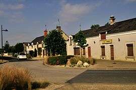
A view within Villers-les-Ormes | |
 Villers-les-Ormes | |
|
Location within Centre-Val de Loire region  Villers-les-Ormes | |
| Coordinates: 46°52′14″N 1°38′01″E / 46.8706°N 1.6336°ECoordinates: 46°52′14″N 1°38′01″E / 46.8706°N 1.6336°E | |
| Country | France |
| Region | Centre-Val de Loire |
| Department | Indre |
| Arrondissement | Châteauroux |
| Canton | Buzançais |
| Intercommunality | Val de l'Indre-Brenne |
| Government | |
| • Mayor (2008–2014) | Eric Bergougnan |
| Area1 | 17.6 km2 (6.8 sq mi) |
| Population (2009)2 | 431 |
| • Density | 24/km2 (63/sq mi) |
| Time zone | CET (UTC+1) |
| • Summer (DST) | CEST (UTC+2) |
| INSEE/Postal code | 36245 / 36250 |
| Elevation |
141–169 m (463–554 ft) (avg. 156 m or 512 ft) |
|
1 French Land Register data, which excludes lakes, ponds, glaciers > 1 km² (0.386 sq mi or 247 acres) and river estuaries. 2 Population without double counting: residents of multiple communes (e.g., students and military personnel) only counted once. | |
Villers-les-Ormes is a former commune in the Indre department in central France. On 1 January 2016, it was merged into the commune of Saint-Maur.[1]
Population
| Historical population | ||
|---|---|---|
| Year | Pop. | ±% |
| 1793 | 230 | — |
| 1800 | 244 | +6.1% |
| 1806 | 249 | +2.0% |
| 1821 | 246 | −1.2% |
| 1831 | 271 | +10.2% |
| 1836 | 258 | −4.8% |
| 1841 | 239 | −7.4% |
| 1846 | 228 | −4.6% |
| 1851 | 280 | +22.8% |
| 1856 | 303 | +8.2% |
| 1861 | 303 | +0.0% |
| 1866 | 317 | +4.6% |
| 1872 | 328 | +3.5% |
| 1876 | 335 | +2.1% |
| 1881 | 357 | +6.6% |
| 1886 | 357 | +0.0% |
| 1891 | 346 | −3.1% |
| 1896 | 317 | −8.4% |
| 1901 | 315 | −0.6% |
| 1906 | 314 | −0.3% |
| 1911 | 324 | +3.2% |
| 1921 | 302 | −6.8% |
| 1926 | 302 | +0.0% |
| 1931 | 294 | −2.6% |
| 1936 | 289 | −1.7% |
| 1946 | 279 | −3.5% |
| 1954 | 307 | +10.0% |
| 1962 | 288 | −6.2% |
| 1968 | 248 | −13.9% |
| 1975 | 251 | +1.2% |
| 1982 | 289 | +15.1% |
| 1990 | 292 | +1.0% |
| 1999 | 338 | +15.8% |
| 2006 | 390 | +15.4% |
| 2009 | 431 | +10.5% |
See also
References
- ↑ Arrêté préfectoral 11 December 2015 (French)
| Wikimedia Commons has media related to Villers-les-Ormes. |
This article is issued from Wikipedia - version of the 2/21/2016. The text is available under the Creative Commons Attribution/Share Alike but additional terms may apply for the media files.