Villers-la-Ville
| Villers-la-Ville | |
|---|---|
| Municipality | |
|
Marbais | |
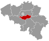
 Villers-la-Ville Location in Belgium | |
|
The municipality of Villers-la-Ville in Walloon Brabant  | |
| Coordinates: 50°35′N 04°32′E / 50.583°N 4.533°ECoordinates: 50°35′N 04°32′E / 50.583°N 4.533°E | |
| Country | Belgium |
| Community | French Community |
| Region | Wallonia |
| Province | Walloon Brabant |
| Arrondissement | Nivelles |
| Government | |
| • Mayor | Emmanuel Burton (MR) |
| • Governing party/ies | MR, PS |
| Area | |
| • Total | 47.45 km2 (18.32 sq mi) |
| Population (1 January 2016)[1] | |
| • Total | 10,498 |
| • Density | 220/km2 (570/sq mi) |
| Postal codes | 1495 |
| Area codes | 071 |
| Website | www.villers-la-ville.be |

Villers-la-Ville is a Walloon municipality located in the Belgian province of Walloon Brabant. On January 1, 2006, Villers-la-Ville had a total population of 9,572. The total area is 47.45 km² which gives a population density of 202 inhabitants per km². The municipality includes also the villages of Marbais, Mellery, Sart-Dames-Avelines and Tilly.
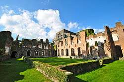
In the north of the village, lie the ruins of the Villers Abbey, which was one of the most important Cistercian abbeys of Europe.
History
To be expanded
Postal history
The MARBAIS post-office opened on 1 June 1838. It used a postal Distribution code 33 with bars (before 1864), and code 235 with points before 1874. The VILLERS-LA-VILLE post-office opened on 10 February 1865. SART-DAMES-AVELINES on 15 October 1877, TILLY on 8 November 1906.[2]
Postal codes in 1969:[3]
- 6318 Marbais
- 6320 Villers-la-Ville
- 6321 Tilly
- 6322 Mellery
- 6328 Sart-Dames-Avelines
Code 1495 since at least October 1990.
Transport
- Villers-la-Ville railway station
- Tilly railway station, in the sub-municipality of Tilly
References
- ↑ Population per municipality as of 1 January 2016 (XLS; 397 KB)
- ↑ Catalogue Spécialisé des Oblitérations Belges, 1849-1910, Nationale en Internationale Postzegelmanifestaties Antwerpen (NIPA), Antwerp, 1999.
- ↑ Liste des Numéros Postaux, Administration des Postes, Bruxelles 1969.
External links
-
 Media related to Villers-la-Ville at Wikimedia Commons
 - Official website (French)
 |
Court-Saint-Étienne | | ||
| Genappe | |
Chastre | ||
| ||||
| | ||||
| Les Bons Villers (WHT) | Fleurus (WHT) | Sombreffe (WNA) |