Villarrica (volcano)
| Villarrica Volcano | |
|---|---|
 View of Villarrica Lake and the eponymous volcano | |
| Highest point | |
| Elevation |
2,860 m (9,380 ft) [1] |
| Prominence |
1,575 m (5,167 ft) [1] |
| Listing |
Region high point Ultra |
| Coordinates | 39°25′15″S 71°56′21″W / 39.42083°S 71.93917°WCoordinates: 39°25′15″S 71°56′21″W / 39.42083°S 71.93917°W [1] |
| Naming | |
| Translation | Place of Wealth (Spanish) |
| Geography | |
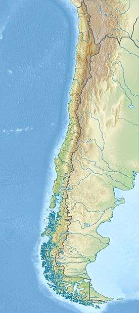 Villarrica Volcano Location in Chile | |
| Location | Southern Chile |
| Parent range | Andes |
| Geology | |
| Age of rock | < Upper Pleistocene |
| Mountain type | Stratovolcano |
| Volcanic belt | South Volcanic Zone |
| Last eruption | December 2014 to June 2015 |
| Climbing | |
| First ascent | 1883, Chilean Army |
| Easiest route | Villarrica ski centre - Piedra Negra |
Villarrica (pronunciation: /ˌviːəˈriːkə/ VEE-ə-REE-kə) (Spanish: Volcán Villarrica, Mapudungun: Ruka Pillañ) is one of Chile's most active volcanoes, rising above the lake and town of the same name, 750 km (470 mi) south of Santiago.[2] It is also known as Rucapillán, a Mapuche word meaning "Pillan's house". It is the westernmost of three large stratovolcanoes that trend NW-SW obliquely perpendicular to the Andean chain along the Mocha-Villarrica Fault Zone,[3] along with Quetrupillán and the Chilean portion of Lanín, are protected within Villarrica National Park. Guided ascents are popular during summer months.
Villarrica, with its lava of basaltic-andesitic composition, is one of a small number worldwide known to have an active (but in this case intermittent) lava lake within its crater. The volcano usually generates strombolian eruptions with ejection of incandescent pyroclasts and lava flows. Rainfall plus melted snow and glacier ice can cause massive lahars (mud and debris flows), such as during the eruptions of 1964 and 1971.
Villarrica is one of 9 volcanoes currently monitored by the Deep Earth Carbon Degassing Project. The project is collecting data on the carbon dioxide and sulphur dioxide emission rates from subaerial volcanoes.[4]
Geography and geology
Villarica stands in the Chilean Central Valley as the westernmost of an alignment of three large stratovolcanoes. The alignment is attributed to the existence of an old fracture in the crust, the North West-South East trending Mocha-Villarrica Fault Zone,[3] the other volcanoes in the chain, Quetrupillán and Lanín, are far less active. The alignment is unusual as it crosses the N-S running Liquiñe-Ofqui Fault, along which several active volcanoes are aligned.[5]
Villarrica covers an area of 400 km2 and has an estimated volume of 250 km3. It contains volcanic caves and about 26 scoria cones. The constant degassing at the lava lake turns the otherwise quite effusive lava more viscous, heightening its explosive potential. Two large ignimbrite layers are visible; the Licán Ignimbrite and the more recent Pucón Ignimbrite.[5]
Villarrica emerged during the Middle Pleistocene and grew forming a large stratocone of similar dimensions to the current edifice. 100,000 years ago during the Valdivia Interglacial the ancestral Villarrica collapsed following an eruption and formed a large elliptical caldera of 6.5 and 4.2 km in diameter. During the Llanquihue glaciation Villarrica produced pyroclastic flow deposits, subglacial andesite lavas and dacite dykes. It collapsed once again 13,700 years ago forming a new smaller caldera, among other pyroclastic flows the Licán Ignimbrite has been related to this event. Beginning with the Licán Ignimbrite, generated just after the last deglaciation, activity continued in similar fashion. The Pucón Ignimbrite was ejected during a minor collapse of the uppermost stratocone 3,700 years ago.[6]
Glaciers
The upper part of Villarrica is permanently covered by snow and has some 40 km2 of glaciers, the largest of which is the Pichillancahue-Turbio Glacier situated on its southeastern flank.[7][8] Ash from the eruptions can increase the ablation of snow and ice by absorption of solar radiation. Some ash coverings are thicker than 5 cm and insulate the glacier, decreasing ablation instead of enhancing it. Between 1961 and 2003, Villarrica lost 25% of its glaciated surface and the glaciers shrank at an average rate of -0.4 km2 each year.[9]
Tourism
Villarrica is popular for climbing with guided hikes to the crater from the town of Pucón, but these may be suspended due to cloud or volcanic activity. Helicopter over-flights have been available since 2007. In the winter (July–September) a ski resort operates on the northern slopes.[10]
Eruptive history

Villarrica is one of Chile's most active volcanoes; eruptions have been recorded since the conquest of Chile and the founding of the city of Villarrica in 1552. There are uncertainties in the eruptive record in the first half of the 17th century due to the Mapuche and Huilliche uprising which led to the surrender or abandonment of Spanish settlements during the destruction of the Seven Cities. The earliest recorded eruption occurred in 1558, followed by at least 65 others with assumed Volcanic Explosivity Indexes of 1-3.
1964 eruption
1.jpg)
In the two last weeks of February 1964 Villarrica produced small, violent lava effusions and tremors. On 1 March, at 2:45 am, it begun a strombolian eruption, and residents of Coñaripe, a wood-logging town, fled to the surrounding hills. Melting snow and ice from the Pichillancahue-Turbio Glacier combined with heavy rainfall to produce several lahars. Coñaripe, on the north-western shores of Calafquén Lake, had about half of its buildings destroyed, necessitating reconstruction further east.
1971 eruption
On 29 October 1971, at 4:00 am, there were several explosions in the crater and a column of black and white smoke appeared. One month later, at quarter to midnight on 29 November, Villarrica begun a new eruptive cycle. Pyroclasts were ejected and the snow surrounding the crater melted. After a brief halt in activity lava pored from a new vent on the north-east side, melting considerable amounts of water and causing lahars. These lahars affected Pichaye, El Turbio, Collentañe, Minetué, Molco, Voipir and Curarrehue, all of them in the Trancura River basin. Toxic sulphurous gases made the air unbreathable in Villarrica and Pucón where at least 15 deaths were reported.[11]
2015 eruption
| 2015 eruption of Villarrica | |
|---|---|
| Volcano | Villarrica |
| Date | March 3, 2015 |
| Type | Strombolian |
| Location |
Villarrica, Araucania Region |
| VEI | 2[12] |
Approximately at 03:01 AM on March 3, 2015, it erupted,[13][14] raising the alert to red up to 10 kilometers around. The eruption exceeded the height of the volcano, causing a loud explosion that woke the neighbors, and forcing the evacuation of 3,385 people in nearby communities.
On February 7, 2015, Villarrica triggered a yellow alert at both Servicio Nacional de Geología y Minería[15][16] and Onemi.[17] Minor explosions and low emissions of ashes were visible.[18] Ten days later, another eruption occurred. The National Service of Geology and Mining (Sernageomin) declared a yellow alert after volcanic and seismic activity increased again, while the National Emergency Office of the Interior Ministry (ONEMI) kept the yellow alert. The Southern Andean Volcano Observatory (OVDAS) indicated that a new imminent eruption would continue until 12:30 of March 19, 2015.[19] As of July 2015,the eruption is continuing.[20] Volcanic gas emissions from this volcano are measured by a Multi-Component Gas Analyzer System, which detects pre-eruptive degassing of rising magmas, improving prediction of volcanic activity.[21]
See also
Gallery
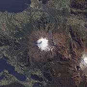 Satellite image of Villarrica
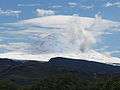 Villarrica
 Climbing Villarrica
 A view from Pucón
References
- 1 2 3 "Argentina and Chile, Central Ultra Prominences". Peaklist.org. Retrieved 2013-07-17.
- ↑ "Volcán Villarrica: Chile". Geographical Names. Retrieved 2015-03-04.
- 1 2 Dzierma et al., 2012. Seismicity near the slip maximum of the 1960 Mw 9.5 Valdivia earthquake (Chile): Plate interface lock and reactivation of the subducted Valdivia Fracture Zone
- ↑ "DECADE Installations at Turrialba and Poás". Deep Carbon Observatory. Retrieved 26 September 2016.
- 1 2 Volcán Villarrica OVDAS
- ↑ Sterns et al. in Teresa Moreno and Wes Gibbons (eds.) The Geology of Chile.
- ↑ "Volcan_villarrica" (PDF). Southern Andean Volcano Observatory. Retrieved 16 May 2015.
- ↑ "Volcan Villarrica" (PDF). Ingentaconnect.com. Retrieved 16 May 2015.
- ↑ Rivera, A., Acuña, C. and Casassa, G. Glacier variations in central Chile (32°S-41°S). Chapter in Glacier science.
- ↑ "Villarrica volcano, Chile". Volcano Photos. Retrieved 2015-03-04.
- ↑ La erupción de 1971, Villarrica Volcano Visual Observation Project. 2008.
- ↑ "Onemi mantiene Alerta Roja mientras continúa disminuyendo actividad en volcán Villarrica". BioBio Chile. Retrieved 3 March 2015.
- ↑ "Volcano Villarrica erupts in southern Chile, villages evacuated". Reuters. 3 March 2015.
- ↑ Amparo Montoya (3 March 2015). "Volcán Villarrica entra en erupción durante la madrugada de este martes". bibiochile.cl.
- ↑ "Volcanic Activity Special Report, Araucania Region" (PDF). SERNAGEOMIN. 6 February 2015.
- ↑ "Mantienen Alerta Amarilla por comportamiento inestable de Volcán Villarrica". BioBio Chile.
- ↑ "Onemi declara alerta amarilla por actividad en el volcán Villarrica". 24 Horas.
- ↑ "Proyecto de Observación Villarrica". POVI.cl.
- ↑ "OVDAS: Monitoreo del volcán Villarrica en vivo". Retrieved 19 March 2015.
- ↑ "Volcanoes are like buses...". Retrieved 20 July 2015.
- ↑ "Volcanic gases emitted during mild Strombolian activity of Villarrica volcano, Chile" (PDF). Retrieved 27 September 2016.
Sources
External links
| Wikimedia Commons has media related to Villarrica Volcano. |
- Satellite photo of Villarrica Volcano
- Villarrica Volcano info on SummitPost.com
- Top of the volcano ...
- Villarrica Volcano Visual Observation Project
- "Volcán Villarrica, Chile" on Peakbagger