Victoria Square, Portland

Victoria Square is a public square on the Isle of Portland, Dorset, England. The square is situated at the entrance to Portland, within close proximity to Chesil Beach, Ocean Quay, and the small fishing village of Chiswell. The square developed during the 19th-century.
History

During the middle of the 19th-century, the railway line from Weymouth was extended to Portland, with construction commencing in 1860.[1] With the erection of the branch terminus at the entrance to Portland, Captain Charles Augustus Manning developed the area into a square. He had the Royal Victoria Hotel, and a terrace opposite, erected at his expense by 1865.[2][3] The railway line and station opened that year.[1]
A range of businesses soon based themselves in the square, including the Portland Gas Works in 1863.[4] A sawmill was erected next to the railway station, by the Portland Stone Company.[5][1][6] A public house known as The Terminus Hotel was also built at the square, and was later renamed The Little Ship.[7] In 1878 local builder John Patten erected Portland's first Masonic Hall at Victoria Square.[8][9] During 1898 a new masonic hall was constructed within the square, opposite the original hall.[10] In 1902, when Portland's railway line was extended to Easton village, the original Portland station would become a goods station.[1]

The Second World War bought many air raids to Portland due to the important naval base.[11] A minefield was laid near the square,[12] and a tank trap was placed near the minefield.[13] When Weymouth and Portland became an embarkation point of Allied Forces for D-Day in 1944, the Royal Victoria Lodge was used as a makeshift hospital.[14] The Portland Gas Works was closed in 1959, and was replaced by a plant hire yard.[15]
Portland's railway operated until it closed to passengers in 1952 and goods in 1965. In 1969, the square's railway station was demolished, and replaced by a roundabout.[1] A commemorative stone and plaque was later placed near the square.[16] Despite a sea wall and defences being put in place between 1958-1965, incidents of widespread flooding still occurred. During December 1978 and February 1979, two major storms caused flooding in Chiswell and Victoria Square. Further flood prevention measures were put in place in the 1980s.[17][18]
In 1995 a refurbishment scheme saw the square enhanced. A commemorative stone was unveiled in 1996 by HRH The Duke of York once the work was completed.[15] The northern area of the square is occupied by grassland. For the millennium, two ornamental pillars, made of Portland Stone, were planned to mark the entrance to Portland. They were erected on the grassland site, and officially 'opened' during June 2004. The pillars were designed to be used as safe nesting sites for seagulls.[16]
Grade listed buildings
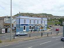
The Little Ship, a pub located at Victoria Square, became Grade II Listed in May 1993. The building, externally, is a complete example of a modest classical-style Victorian pub, holding a very important corner to this Square.[19] The Royal Victoria Hotel also became Grade II Listed at the same time. Again it holds an important position on the corner of the Square, complementing The Little Ship opposite.[20]
Portland Skate Park
The other section of Victoria Square's recreation ground, not to be transformed as a car park, would become the Portland Skate Park.[21] It was first established around 2005, at a cost of £20,000. However, in June 2009, the park was set to be removed after complaints of crumbling, rusty metal ramps.[22] Afterwards work commenced on a new £200,000 skate park for the same site. In November 2010 the park was officially opened, with 150 young people from across Dorset attending the event.[23]
References
- 1 2 3 4 5 http://www.disused-stations.org.uk/p/portland_first/
- ↑ Morris, Stuart (2016). Portland, an Illustrated History. Dovecote Press. p. 88. ISBN 978-0-9955462-0-2.
- ↑ http://www.geoffkirby.co.uk/PortlandArchivePictures/html/public_houses.html
- ↑ http://www.pbenyon.plus.com/Portland/PYB/Gas_Works.html
- ↑ Morris, Stuart (2016). Portland, an Illustrated History. Dovecote Press. p. 103. ISBN 978-0-9955462-0-2.
- ↑ http://www.geoffkirby.co.uk/PortlandArchivePictures/html/chiswell.html
- ↑ http://www.opcdorset.org/PortlandFiles/PortlandCensus/1881PortlandC.htm
- ↑ Morris, Stuart (2016). Portland, an Illustrated History. Dovecote Press. p. 92. ISBN 978-0-9955462-0-2.
- ↑ Portland Urban District Council (c. 1957). Isle of Portland Official Guide. Ed. J. Burrow & Co. Ltd., Publishers - Chelternham and London. p. 23.
- ↑ "Portland Churches, Buildings and Views". ancestry.com. Retrieved 28 March 2015.
- ↑ http://www.dorsetlife.co.uk/2012/10/danger-uxb/
- ↑ Historic England. "Monument No. 1420418". PastScape. Retrieved 3 October 2015.
- ↑ Historic England. "Monument No. 1420321". PastScape. Retrieved 3 October 2015.
- ↑ http://www.dorsetecho.co.uk/news/8905401.royal_victoria_lodge_re_opens_on_portland/
- 1 2 Morris, Stuart (1998). Discover Dorset: Portland. Dovecote Press. p. 13. ISBN 978-1874336495.
- 1 2 http://www.geoffkirby.co.uk/Portland/680735/
- ↑ Morris, Stuart (2016). Portland, an Illustrated History. Dovecote Press. p. 150-151. ISBN 978-0-9955462-0-2.
- ↑ https://www.dorsetforyou.com/media/203969/Storms-and-Coastal-Defences-at-Chiswell/pdf/Storms_and_Coastal_Defences_at_Chiswell_WEB.pdf
- ↑ Historic England. "Details from listed building database (1206281)". National Heritage List for England. Retrieved 26 June 2014.
- ↑ Historic England. "Details from listed building database (1281836)". National Heritage List for England. Retrieved 26 June 2014.
- ↑ http://familyinformationdirectory.dorsetforyou.com/kb5/dorset/fsd/service.page?id=rYHDhfBZhLw
- ↑ http://www.viewfrompublishing.co.uk/news_view/7516/11/1/portland-skaters-flock-back-to-new-park
- ↑ http://www.dorsetecho.co.uk/news/8670722.Portland_Skate_Park_officially_open/
Coordinates: 50°33′48″N 2°26′59″W / 50.5633°N 2.4498°W