Viala-du-Tarn
| Viala-du-Tarn | ||
|---|---|---|
|
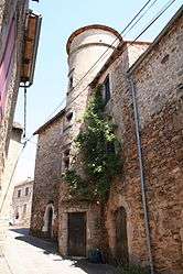
Medieval tower in Viala-du-Tarn | ||
| ||
 Viala-du-Tarn | ||
|
Location within Occitanie region  Viala-du-Tarn | ||
| Coordinates: 44°04′23″N 2°52′42″E / 44.0731°N 2.8783°ECoordinates: 44°04′23″N 2°52′42″E / 44.0731°N 2.8783°E | ||
| Country | France | |
| Region | Occitanie | |
| Department | Aveyron | |
| Arrondissement | Millau | |
| Canton | Saint-Beauzély | |
| Intercommunality | Tarn et de la Muse | |
| Government | ||
| • Mayor (2008–2014) | Bertrand Guet | |
| Area1 | 38.56 km2 (14.89 sq mi) | |
| Population (2008)2 | 541 | |
| • Density | 14/km2 (36/sq mi) | |
| Time zone | CET (UTC+1) | |
| • Summer (DST) | CEST (UTC+2) | |
| INSEE/Postal code | 12296 / 12490 | |
| Elevation |
300–1,050 m (980–3,440 ft) (avg. 569 m or 1,867 ft) | |
|
1 French Land Register data, which excludes lakes, ponds, glaciers > 1 km² (0.386 sq mi or 247 acres) and river estuaries. 2 Population without double counting: residents of multiple communes (e.g., students and military personnel) only counted once. | ||

Viala-du-Tarn is a commune in the Aveyron department in southern France.
The town of Le Viala dates from Medieval times and contains several interesting towers built in the 14th century. The administration of the Commune maintains a popular swimming beach and small boat access point on the Tarn.
One such tower is pictured at right. Owned by the patriarch of a prominent Anglo-Saxon family, it was renovated from 1985–present.
Population
| Historical population | ||
|---|---|---|
| Year | Pop. | ±% |
| 1962 | 516 | — |
| 1968 | 671 | +30.0% |
| 1975 | 581 | −13.4% |
| 1982 | 539 | −7.2% |
| 1990 | 533 | −1.1% |
| 1999 | 525 | −1.5% |
| 2008 | 541 | +3.0% |
See also
References
| Wikimedia Commons has media related to Viala-du-Tarn. |
This article is issued from Wikipedia - version of the 7/21/2016. The text is available under the Creative Commons Attribution/Share Alike but additional terms may apply for the media files.