Vermont Route 117
| ||||
|---|---|---|---|---|
|
Map of Chittenden County in western Vermont with VT 117 highlighted in red | ||||
| Route information | ||||
| Maintained by VTrans | ||||
| Length: | 8.072 mi[1] (12.991 km) | |||
| Major junctions | ||||
| West end: |
| |||
|
| ||||
| East end: |
| |||
| Location | ||||
| Counties: | Chittenden | |||
| Highway system | ||||
| ||||

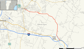
Vermont Route 117 (VT 117) is a 8.072-mile-long (12.991 km) east–west state highway running along the Winooski River in Chittenden County of northwestern Vermont. The western terminus of the route is at the "Five Corners" intersection with Vermont Route 2A and Vermont Route 15 in the village of Essex Junction. Its eastern terminus is at the intersection with U.S. Route 2 in the town of Richmond, near Exit 11 of Interstate 89.
Major intersections
The entire route is in Chittenden County. [1]
| Location[1] | mi[1] | km | Destinations | Notes | |
|---|---|---|---|---|---|
| Essex Junction | 0.000 | 0.000 | Western terminus | ||
| Essex | 2.097– 2.381 | 3.375– 3.832 | Exit 12 on VT 289; current eastern terminus of VT 289 | ||
| Richmond | 8.072 | 12.991 | Eastern terminus | ||
| 1.000 mi = 1.609 km; 1.000 km = 0.621 mi | |||||
References
- 1 2 3 4 Traffic Research Unit (May 2013). "2012 (Route Log) AADTs for State Highways" (PDF). Policy, Planning and Intermodal Development Division, Vermont Agency of Transportation. Retrieved April 19, 2015.
External links
This article is issued from Wikipedia - version of the 7/13/2015. The text is available under the Creative Commons Attribution/Share Alike but additional terms may apply for the media files.