Vermillion River (Minnesota)
| Vermillion River | |
|---|---|
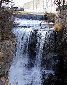 Vermillion Falls in Hastings | |
| Country | United States |
| Basin | |
| Main source | Eastern Scott County, Minnesota |
| River mouth | Mississippi River |
| Basin size | 335 sq mi (870 km2)[1] |
| Physical characteristics | |
| Length | 59.6 mi (95.9 km)[2] |
The Vermillion River is a 59.6-mile (95.9 km)[2] waterway that meanders through Scott County and Dakota County in Minnesota, entering the Mississippi River floodplain just south of Hastings. 13.5 miles (21.7 km) of it are designated as a trout stream, which is unusual for being so close to a metropolitan area.[1]
Vermillion, derived from the French for "red" was probably so named from deposits of ochre Indians used for body painting.[3]
The Vermillion is a state-designated trout stream, managed for catch-and-release fishing of brown trout. The portion of the river that supports trout is upstream, around the towns of Farmington; Empire, and the City of Lakeville. Near the town of Vermillion, the water becomes too warm to support trout. Downstream from the falls on the south side of Hastings, the water becomes even warmer, supporting riverine species such as northern pike and freshwater drum. The Minnesota state record black crappie of 5.0 pounds was caught in the Vermillion River in 1940.[4] An old channel of the Vermillion River continues south from Hastings on the western edge of the Mississippi valley.
In the nineteenth and early twentieth century, the river was used for water power, supplying power to gristmills. A park surrounding the falls preserves the remains of a mill operated by Alexander Ramsey, one of the leading citizens of early Minnesota.
The nonprofit conservation group Minnesota Trout Unlimited and its volunteers have invested hundreds of thousands of dollars in physical restoration of the river and adjoining upland areas, funding four projects through grants from the state's Outdoor Heritage Fund. The Twin Cities chapter of Trout Unlimited sponsors a local community volunteer group called the Vermillion Riverkeepers. Volunteers work with the Minnesota Department of Natural Resources to remove invasive non-native species such as buckthorn from several state DNR Aquatic Management Areas (AMAs), in addition to fisheries research and stream restoration projects . [5]
Another group, the Vermillion Stewards program, engages people in cleanups, restoration events and educational activities and is operated by Friends of the Mississippi River.
Gallery of images
 Vermillion River upper falls in Hastings
 Vermillion River valley in Hastings
 Vermillion River valley in Hastings
 Ruin of the 1857 Ramsey Mill
See also
References
- 1 2 Vermillion River Watershed Joint Powers Organization. "The Vermillion River Watershed". Dakota County. Retrieved 2006-11-11.
- 1 2 U.S. Geological Survey. National Hydrography Dataset high-resolution flowline data. The National Map Archived 2012-04-05 at WebCite, accessed October 4, 2012
- ↑ Upham, Warren (1920). Minnesota Geographic Names: Their Origin and Historic Significance. Minnesota Historical Society. p. 169.
- ↑ "State record fish". Minnesota DNR. Retrieved 2007-03-31.
- ↑ "Twin Cities Trout Unlimited". Retrieved 2015-12-12.
Coordinates: 44°43′50″N 92°50′30″W / 44.7305372°N 92.84178°W