Veelerveen
| Veelerveen | |
|---|---|
| Village | |
|
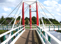
Three-way bridge Noabers Badde in 2005 | |
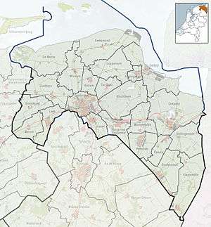 Veelerveen Location of Veelerveen in the province of Groningen | |
| Coordinates: 53°3′20″N 7°7′40″E / 53.05556°N 7.12778°ECoordinates: 53°3′20″N 7°7′40″E / 53.05556°N 7.12778°E | |
| Country | Netherlands |
| Province | Groningen |
| Municipality | Bellingwedde |
| Area (2012)[1] | |
| • Total | 430 ha (1,060 acres) |
| • Land | 423 ha (1,045 acres) |
| • Water | 7 ha (17 acres) |
| Population (2012)[1] | |
| • Total | 590 |
| • Density | 140/km2 (360/sq mi) |
| Postcode | 9566[2] |
| Area code | 0597 |
Veelerveen (Dutch pronunciation: [ˌveːlərˈveːn]) is a linear village with a population of 590 in the municipality of Bellingwedde in the Netherlands.
History
In 1968, Veelerveen became part of Bellingwedde.
Geography
Veelerveen is located at 53°3′20″N 7°7′40″E / 53.05556°N 7.12778°E in south of the municipality of Bellingwedde in the east province of Groningen in the northeast of the Netherlands. It is situated in the region of Westerwolde.[3]
In the northwest it is close to the village of Wedde, in the north to Vriescheloo, in the northeast to Bellingwolde, in the southeast to Bourtange, and in the southwest to Vlagtwedde.
The village is a linear settlement alongside the Ruiten-Aa-kanaal and B.L. Tijdenskanaal. The canals Mussel-Aa-kanaal, Ruiten-Aa-kanaal, and B.L. Tijdenskanaal come together at the village centre where the three-way bridge Noabers Badde connects the canal banks.[3]
Veelerveen is an administrative neighbourhood (Dutch: buurt) and has a total area of 430 ha (1,100 acres) of which 423 ha (1,050 acres) is land and 7 ha (17 acres) is water.[1]
Demographics
In 2012, Veelerveen neighbourhood had a population of 590 and a population density of 140/km2 (360/sq mi).[1]
Attractions
Nieman's Mill (Gronings: Niemans Meuln) is a smock mill that was built in 1916. It has been listed as a national heritage site since 1972.[4]
 Map of Bellingwedde with Veelerveen in red
 Nieman's Mill in 1969
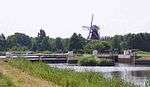 Sluice in the B.L. Tijdenskanaal with Nieman's Mill in the background in 2005
References
- 1 2 3 4 (Dutch) Kerncijfers wijken en buurten 2009-2012, Statistics Netherlands, 2014. Retrieved on 27 April 2014.
- ↑ (Dutch) Resultaten voor "Veelerveen,", Postcode.nl. Retrieved on 27 April 2014.
- 1 2 (Dutch) Veelerveen, Municipality of Bellingwedde. Retrieved on 27 April 2014.
- ↑ (Dutch) Monumentnummer: 8921, Rijksdienst voor het Cultureel Erfgoed. Retrieved on 27 April 2014.
External links
| Wikimedia Commons has media related to Veelerveen. |
- (Dutch) Veelerveen, website about the village
 |
Wedde | Vriescheloo | Bellingwolde | |
| |
||||
| ||||
| | ||||
| Vlagtwedde | Bourtange |