Vatheia
| Vatheia Βαθειά | |
|---|---|
|
View of Vatheia | |
 Vatheia | |
| Coordinates: 36°27.2′N 22°28.0′E / 36.4533°N 22.4667°ECoordinates: 36°27.2′N 22°28.0′E / 36.4533°N 22.4667°E | |
| Country | Greece |
| Administrative region | Peloponnese |
| Regional unit | Laconia |
| Municipality | East Mani |
| Municipal unit | Oitylo |
| Elevation | 180 m (590 ft) |
| Community[1] | |
| • Population | 33 (2011) |
| Time zone | EET (UTC+2) |
| • Summer (DST) | EEST (UTC+3) |
| Postal code | 230 71 |
| Area code(s) | 27330 |
| Website |
www |

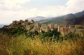
Vatheia (Greek: Βάθεια, Greek pronunciation: [vaθˈja], also Vathia) is a village on the Mani Peninsula,in south-eastern Laconia. The local community of Vatheia is named after this village. The aforementioned local community is a subdivision of the municipal unit of Oitylo. It is known for its tower-houses built on a hill dominating the surrounding countryside. Vatheia is linked by road north to Areopoli and Kalamata and south to Cape Matapan also known as Tenaro. In the northern and eastern direction, the southern reaches of the Saggias mountain range overlook the village. Farmland and maquis shrubland cover the hill slopes. On the hills and mountain sides around Vatheia proper are clusters of abandoned houses, towers and chapels known as the perichora, meaning environs. Currently, Vatheia is a tourist attraction during spring and summer due to the abundance of wild flowers that cover the nearby hills and its scenic views. Moreover, it serves as an iconic example of the south Maniot vernacular architecture as it developed during the 19th century. The nearest villages are Kyparissos, Alika and Gerolimenas to the north-west and Lagia to the north-east.
History
Little is known about the history of Vatheia before the second half of the 17th century. As is generally the case of Mani south of Oitylo, the main sources of information are archaeological and architectural studies dealing with the plentiful churches and the abandoned ruins of old villages known locally as palaiochores. Sparse references can also be found in private diaries, travel itineraries, correspondence and the occasional censuses of Venetian or Ottoman authorities. However, only a fraction of the studies pertaining to the general area of south Mani are published outside of academia.
In several places around the modern village as well as in other locations within the periphery of the local community, earlier habitation is evident by the megalithic remains of housing clusters. The closest to modern Vatheia are the Palaiochora built along a stream below the modern village, the Kostakianika Kalyvia built on the hillside a short distance to the north-west and Pachia a similar hamlet on the mountainside just opposite the hill of modern Vatheia. They belong to the category of megalithic structures named after the large, roughly-hewn blocks of stone used by the builders. This is a term used throughout Mani to describe the older abandoned settlements sharing the aforementioned characteristic construction.
Historical population
| Year | Population |
|---|---|
| 1981 | 60 |
| 1991 | 113 |
| 2001 | 216 |
| 2011 | 33 |
See also
References
- ↑ "Απογραφή Πληθυσμού - Κατοικιών 2011. ΜΟΝΙΜΟΣ Πληθυσμός" (in Greek). Hellenic Statistical Authority.
| Wikimedia Commons has media related to Vatheia. |