Vat Phou
| Vat Phou and Associated Ancient Settlements within the Champasak Cultural Landscape | |
|---|---|
| Name as inscribed on the World Heritage List | |
 | |
| Type | Cultural |
| Criteria | iii, iv, vi |
| Reference | 481 |
| UNESCO region | Asia-Pacific |
| Coordinates | 14°50′54″N 105°49′03″E / 14.848264°N 105.8176°ECoordinates: 14°50′54″N 105°49′03″E / 14.848264°N 105.8176°E |
| Inscription history | |
| Inscription | 2001 (25th Session) |
 Location of Vat Phou in Laos. | |
Vat Phou (or Wat Phu; Lao: ວັດພູ [wāt pʰúː] temple-mountain) is a ruined Khmer Hindu temple complex in southern Laos. It is located at the base of mount Phu kao, some 6 kilometres (3.7 mi) from the Mekong in Champasak Province. There was a temple on the site as early as the 5th century, but the surviving structures date from the 11th to 13th centuries. The temple has a unique structure, in which the elements lead to a shrine where a lingam dedicated to Lord Shiva was bathed in water from a mountain spring. The site later became a centre of Theravada Buddhist worship, which it remains today.
History

Vat Phou was initially associated with the city of Shrestapura,[1]:66 which lay on the bank of the Mekong directly east of Lingaparvata Mountain (now called Phou Khao). By the latter part of the fifth century, the city was already the capital of a kingdom that texts and inscriptions connect with both the Chenla Kingdom and Champa and the first structure on the mountain was constructed around this time. The mountain gained spiritual importance from the lingam-shaped protuberance on its summit; the mountain itself was therefore considered the home of Shiva, and the river as representing the ocean or the Ganges. The temple was naturally dedicated to Shiva, while the water from the spring which emerges directly behind the temple was considered sacred.
Vat Phou was a part of the Khmer Empire centred on Angkor to the southwest, at least as early as the reign of Yasovarman I in the early 10th century. Shrestapura was superseded by a new city in the Angkorian period, located directly south of the temple. In the later period, the original buildings were replaced, re-using some of the stone blocks; the temple now seen was built primarily during the Koh Ker and Baphuon periods of the 11th century. Minor changes were made during the following two centuries, before the temple, like most in the empire, was converted to Theravada Buddhist use. This continued after the area came under control of the Lao, and a festival is held on the site each February. Little restoration work has been done, other than the restoration of boundary posts along the path. Vat Phou was designated a World Heritage Site in 2001.
The site

Like most Khmer temples, Vat Phou is orientated towards the east, although the axis actually faces eight degrees south of due east, being determined primarily by the orientation of the mountain and the river. Including the barays (reservoirs), it stretches 1.4 kilometres (0.87 mi) east from the source of the spring, at the base of a cliff 100 metres (330 ft) up the hill. 6 kilometres (3.7 mi) east of the temple, on the west bank of the Mekong, lay the city, while a road south from the temple itself led to other temples and ultimately to the city of Angkor.

Approached from the city (of which little remains), the first part of the temple reached is a series of barays. Only one now contains water, the 600 by 200 m middle baray which lies directly along the temples's axis; there were further reservoirs north and south of this, and a further pair on each side of the causeway between the middle baray and the palaces.
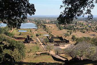
The two palaces stand on a terrace on either side of the axis. They are known as the north and south palaces or, without any evidence, the men's and women's palaces (the term "palace" is also a mere convention — their purpose is unknown). Each consisted of a rectangular courtyard with a corridor and entrance on the side towards the axis, and false doors at the east and west ends. The courtyards of both buildings have laterite walls; the walls of the northern palace's corridor are also laterite, while those of the southern palace are sandstone. The northern building is now in better condition. The palaces are notable chiefly for their pediments and lintels, which are in the early Angkor Wat style.
The next terrace has a small shrine to Nandi (Shiva's mount) to the south, in poor condition. The road connecting Vat Phou to Angkor ran south from this temple. Continuing west, successive staircases lead up further terraces; between them stands a dvarapala which has come to be worshipped as king Kammatha, mythical builder of the temple. On the narrow next terrace are the remains of six small shrines destroyed by treasure-hunters.
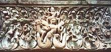
The path culminates in seven sandstone tiers which rise to the upper terrace and central sanctuary. The sanctuary is in two parts. The front section, of sandstone, is now occupied by four buddha images, while the brick rear part, which formerly contained the central lingam, is empty. The entire roof is missing, although a makeshift covering has been added to the front. Water from the spring which emerges from the cliff about 60 m southwest of the sanctuary was channeled along stone aqueducts into the rear chamber, continuously bathing the lingam. The sanctuary is later than the north and south palaces, belonging to the Baphuon period of the later 11th century. The east side has three doorways: from south to north, their pediments show Krishna defeating the nāga Kaliya; Indra riding Airavata; and Vishnu riding Garuda. The east wall bears dvarapalas and devatas. Entrances to the south and north bear have inner and outer lintels, including one to the south of Krishna ripping Kamsa apart.

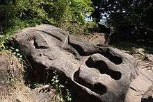
Other features of the area are a library, in poor condition, south of the sanctuary, and a relief of the Trimurti to the northwest. There are other carvings further north: a Buddha footprint on the cliff face, and boulders shaped to resemble elephants and a crocodile. The crocodile stone has acquired some notoriety as being possibly the site of an annual human sacrifice described in a sixth-century Chinese text; the identification is lent some plausibility by the similarity of the crocodile's dimensions to those of a human.
The Present
Global Heritage Fund, in association with the Lerici Institute (Italy) and the government of Laos, is providing emergency conservation of temple structures at this largest of archaeological sites in Laos. The stabilization and sustained conservation of Nandin Hall is the primary focus of these efforts, however the Global Heritage Fund-led team is working with local communities for training and development.
Within the framework of French – Lao cooperation project : " Priority solidarity funds Vat Phu Champassak. Historic and Cultural site arrangement and development ". The project has for objectives:
- The institutional support for the creation of a body specialized management of the site.
- The training of the scientific, technical and administrative staff.
- The development of the site and its economic valuation.
The Indian Team from Archaeological survey of India, headed by Er. R. S. Jamwal arrived again in June 2009 at Vat Phou and conducted studies of foundations, drainage problems, super structural elements as well as did the documentation, recording, survey work etc. for the Northern Quadrangle of temple complex. The conservation and Restoration work of Northern Quadrangle is likely to be commenced from ensuing working season.
Notes
- ↑ Cœdès, George (1968). Walter F. Vella, ed. The Indianized States of Southeast Asia. trans.Susan Brown Cowing. University of Hawaii Press. ISBN 978-0-8248-0368-1.
- ^ Projet de Recherches en Archaeologie Lao. Vat Phu: The Ancient City, The Sanctuary, The Spring (pamphlet).
- ^ Freeman, A Guide to Khmer Temples in Thailand and Laos p. 200-201.
- ^ ICOMOS report p. 71.
- ^ ICOMOS report p. 72.
- ^ Global Heritage Fund - Where We Work - Wat Phu, Laos Accessed on 2009-04-28.
- ^ Global Heritage Fund - Where We Work - Wat Phu, Laos Accessed on 2009-04-28.
References
- É. Aymonier, Le Cambodge. II Les provinces siamoises, Paris 1901;
- E. Lunet de Lajonquiére, Inventaire descriptif des monuments d’Indochine. Le Cambodge, II, Paris 1907;
- H. Marchal, Le Temple de Vat Phou, province de Champassak, Éd. du département des Cultes du Gouvernement royal du Laos
- H Parmentier, «Le temple de Vat Phu», Bulletin de l’École Française d’Extrême-Orient, 14/2, 1914, p. 1-31;
- M. Freeman, A Guide to Khmer Temples in Thailand and Laos. Weatherhill 1996. ISBN 0-8348-0450-6.
- M. Santoni et al., «Excavations at Champasak and Wat Phu (Southern Laos) », in R. Ciarla, F. Rispoli (ed.), South-East Asian Archaeology 1992, Roma 1997, p. 233-63;
- M. Cucarzi, O. Nalesini et al., «Carta archeologica informatizzata: il progetto UNESCO per l’area di Wat Phu», in B. Amendolea (ed.), Carta archeologica e pianificazione territoriale, Roma 1999, p. 264-71;
- UNESCO Champasak Heritage Management Plan, Bangkok 1999 ;
- International Council on Monuments and Sites report on World Heritage Site application, September 2001;
- O. Nalesini, «Wat Phu», in Enciclopedia archeologica. Asia, Roma 2005.
- Ch. Higham. The Civilization of Angkor. Phoenix 2001. ISBN 1-84212-584-2.
- Projet de Recherches en Archaeologie Lao. Vat Phu: The Ancient City, The Sanctuary, The Spring (pamphlet).
- Global Heritage Fund - Where We Work - Wat Phu, Laos Accessed on 2009-04-28.
- Recherches nouvelles sur le Laos - EFEO(école française d'extrême orient) - Yves Goudineau & Michel Lorrillard - 2008 - 678 pages.
External links
- Official Vat Phu Website - history, timetable, news, projects, and more
- Wat Phu preservation project summary at Global Heritage Fund
- Explore Wat Phu with Google Earth on Global Heritage Network
- Laos Travel Guide Wat Phu Champasak
| ||
Coordinates: 14°50′53.75″N 105°49′3.36″E / 14.8482639°N 105.8176000°E