Varva, Chernihiv Oblast
| Varva Варва | |||
|---|---|---|---|
| |||
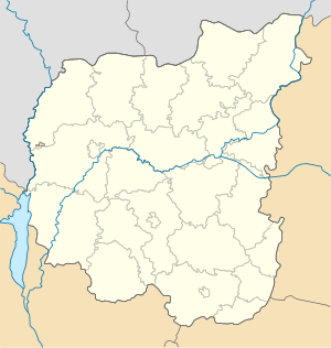 Varva Location of Varva | |||
| Coordinates: 50°29′42″N 32°43′25″E / 50.49500°N 32.72361°ECoordinates: 50°29′42″N 32°43′25″E / 50.49500°N 32.72361°E | |||
| Country Oblast Raion |
Ukraine Chernihiv Oblast Varva Raion | ||
| Founded | 1079 | ||
| Rayon Center | 1960 | ||
| Government | |||
| • Mayor | Pavlo Skudnyi | ||
| Population | |||
| • Total | 8,773 | ||
| Postal code | 17600 | ||
| Area code(s) | + 380 4636 | ||
| Website | None | ||

Varva (Ukrainian: Варва) is a town in the Chernihiv Oblast of Ukraine, located at 50°29′42″N 32°43′25″E / 50.49500°N 32.72361°E with a current population of 8,773.
History
Varva was founded at the site of a ancient settlement called Varyn which was referenced in 1079 within the "Instructions of Vladimir Monomakh", which was apparently the name of the village.
For various reasons from the 14th to 16th century. Varva was a part of Lithuania and Poland which had the Magdeburg Laws. In the 17th century. population of the town was aprx. 6,500 people, with about 200 being Cossack.
During the famine of 1932-1933 called the Holodomor about 350 people were killed in the area with another 104 people suffering other punishments under the Stalin regime throughout the late 1930s.
On February 27, 1943 the village was the center for an anti-fascist uprising, during the time of the Nazi occupation of Ukraine however this small uprising only extended existed within two Oblasts, Chernihiv and Dnipropetrovsk.
During World War II, Varva was temporarily occupied by Nazi forces from September 17, 1941 until September 17, 1943. After the February 27, 1943 anti-fascist uprising, the participants formed guerillia groups to resist the occuping force from March 1943 until the end of the war.
During the later part of the 1960s the discovery of oil and gas in the Varva Raion contributed to the successful socio-economic development of the whole region.
Geography and Climate
The town Varva is located in the southeast part of Chernihiv, on the southern Poltava plains. Basically the entire area is a smooth, flat surface, sometimes dissected with passable valleys, gullies and ravines. The climate is continental with an average January temperature of 10 degrees and a summer July temperature of 25. The annual precipitation is about 550 mm, the snow cover is 15–20 cm and lasts about 100 days.
Soils in the area are predominantly black (84% of the area), there are some places where the group is composed of chernozem, peat and saline. The area contain 6,000 hectares of forest (growing mostly oak, maple, birch, linden, alder, aspen, pine).
Varva altitude - 153 meters (501.969 ft) above sea level.
Varva is located on the left bank of the river Udai which has a length of 327 km. In the village created two artificial reservoirs, so-called first and second vodopidyomy.
Demographics
The area is populated by ethnic Ukrainians, Russians, Belorussians, Tatars and others.
1. Ukrainian: 94%; (7809 pers.)
  Russians: 4%; (332 pers.)
  Belarusians:  0.7%; (58 people.)
  Tatars:  0.06%; (5 pers.)
  Others:  1.24%. (103 people).
2. Employed: - total 4106 people.
  Unemployed:- 4201 people.
  including pensioners: - 2625 people.
  unemployed: - 162 people.
3. Age Range: (Children under 18 - 1938 people),(18-35 g. - 1532 people), (36-59 g. - 2469 people), (60 and older - 2395 people).
4. Orthodox (Ukrainian Orthodox Church, the Ukrainian Orthodox Church Kiev Patriarchate) and adherents of other churches: Evangelical Christians-Baptists, Seventh Day Adventists and others.
*The above data has reporting gaps where not all the population is represented.
Economy
Varva was known in the second half of the twentieth century for its oil and gas reserves that have been commercially explored in the past.
Currently there are two major employers within the town. First is a gas processing plant, Hnidyntsivsky Gas, which has been in operation for several decades and currently employs about two-thousand people. Second is the JV Agricultual Enterprise, "Druzhba-Nova", which includes the company "Kernal" and collectively employs another two-thousand people.
Culture
There are several catering and private bars in Varva and while tourism is not well developed there are several hiking trails around and through out the city.
Each year on the 17th of September there is a "village day", where traditionally a fair is held where residents participant with collective art shows.
In the center of the village square is a "Fairy-tale Village", made in 1924, with gazebos, children's playgrounds, place of registration for special town events and several memoral signs.
Along 'Peace Street' is the Park of Glory, made in 1967, which has the Obelisk of Glory, Alley of Glory and several of memorials.
Infrastructure
Varva is an urban village which is located 200 km from the regional center, Chernihiv and 35 km from the railway station in Pryluky. The only transportion system is over its roads both domestic and long distance.
Today in the town there 49 multi-storey buildings, 93 streets and alleys, 1856 residential buildings and 1810 individual households.
The village has two artificial reservoirs, called Reservoir 1 and 2.
External links
| Raions | |||||||
|---|---|---|---|---|---|---|---|
| Cities |
| ||||||
| |||||||