Vartdal
| Vartdal herad | |
|---|---|
| Former Municipality | |
|
View of Sætre in Vartdal | |
 Vartdal Location in Møre og Romsdal | |
| Coordinates: 62°18′01″N 06°04′59″E / 62.30028°N 6.08306°ECoordinates: 62°18′01″N 06°04′59″E / 62.30028°N 6.08306°E | |
| Country | Norway |
| Region | Western Norway |
| County | Møre og Romsdal |
| District | Sunnmøre |
| Adm. Center | Sætre |
| Area[1] | |
| • Total | 125 km2 (48 sq mi) |
| ISO 3166 code | NO-1521 |
| Created from | Ulstein Municipality in 1895 |
| Merged into | Ørsta Municipality in 1964 |
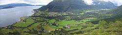
Vartdal is a former municipality in Møre og Romsdal county, Norway. The area of Vartdal is now a part of Ørsta Municipality. The administrative centre was the village Sætre, which is also known as Vartdal. The former municipality encompassed the northwestern part of present-day Ørsta Municipality, along the Vartdalsfjorden, including the villages of Flåskjer, Sætre, and Nordre Vartdal. The highway European route E39 highway runs along the edge of the fjord all the way through Vartdal.[1] The main church for Vartdal was Vartdal Church, located in the village of Nordre Vartdal.
History
The municipality was established on 1 January 1895 when all of Ulstein Municipality located south of the Vartdalsfjorden was separated from the rest of Ulstein to form a new municipality which was called Vartdalsstrand. The new municipality had an initial population of 736. The name was changed (shortened) to Vartdal in 1918. On 1 January 1964, Vartdal was merged with the neighboring municipalities of Hjørundfjord and Ørsta to form the new, larger Ørsta Municipality. Prior to the merger, Vartdal had a population of 1,315.[2]
Notable residents
References
- 1 2 Store norske leksikon. "Vartdal. – kommune" (in Norwegian). Retrieved 2010-09-22.
- ↑ Jukvam, Dag (1999). "Historisk oversikt over endringer i kommune- og fylkesinndelingen" (PDF) (in Norwegian). Statistisk sentralbyrå.