Valley-Hi, Pennsylvania
| Valley-Hi, Pennsylvania | |
|---|---|
| Borough | |
|
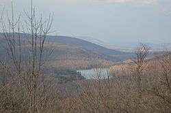
Overview from US Route 30 | |
 Location of Valley-Hi in Fulton County | |
 Valley-Hi  Valley-Hi Location of Valley-Hi in Pennsylvania | |
| Coordinates: 40°1′34″N 78°11′46″W / 40.02611°N 78.19611°WCoordinates: 40°1′34″N 78°11′46″W / 40.02611°N 78.19611°W | |
| Country | United States |
| State | Pennsylvania |
| County | Fulton County |
| Government | |
| • Mayor | Roy Gothie |
| Area | |
| • Total | 0.57 sq mi (1.47 km2) |
| • Land | 0.51 sq mi (1.31 km2) |
| • Water | 0.07 sq mi (0.17 km2) |
| Population (2010) | |
| • Total | 15 |
| • Density | 30/sq mi (11.5/km2) |
| Time zone | EST (UTC-4) |
| • Summer (DST) | EDT (UTC-5) |
| ZIP code | 15533 |
| Area code(s) | 814 |
| FIPS code | 42-79644 |
Valley-Hi is a borough in Fulton County, Pennsylvania, United States. The population was 15 at the 2010 census.[1]
Geography
Valley-Hi is located in northwestern Fulton County at 40°1′34″N 78°11′46″W / 40.02611°N 78.19611°W (40.026222, -78.196071).[2]
According to the United States Census Bureau, the borough has a total area of 0.58 square miles (1.5 km2), of which 0.50 square miles (1.3 km2) is land and 0.08 square miles (0.2 km2), or 11.36%, is water, consisting of a reservoir around which the community is situated.
Demographics
| Historical population | |||
|---|---|---|---|
| Census | Pop. | %± | |
| 1980 | 8 | — | |
| 1990 | 19 | 137.5% | |
| 2000 | 20 | 5.3% | |
| 2010 | 15 | −25.0% | |
| Est. 2015 | 15 | [3] | 0.0% |
| Sources:[4][5][6] | |||
2010 census
As of the census of 2010, there were 15 people, 6 households, and 5 families residing within the borough. The population density was 30.0 people per square mile (11.5/km²). There were 30 housing units at an average density of 60.0 per square mile (23.1/km²). The racial makeup of the borough was 100% White.[7]
There were 6 households, out of which 2 had children under the age of 18 living with them, 83.3% were headed by married couples living together, and 16.7% were non-families. 16.7% of all households were made up of individuals, and none had someone living alone who was 65 years of age or older. The average household size was 2.50, and the average family size was 2.80.[7]
In the borough the population was spread out, with 26.7% under age 18, 0% from 18 to 24, 46.6% from 25 to 44, 6.7% from 45 to 64, and 20.0% who were 65 years of age or older. The median age was 38.5 years. For every 100 females there were 114.3 males. For every 100 females age 18 and over, there were 83.3 males.[7]
2000 census
As of the census[5] of 2000, there were 20 people, 7 households, and 4 families residing in the borough. The population density was 39.7 people per square mile (15.4/km²). There were 29 housing units at an average density of 57.5 per square mile (22.4/km²). The racial makeup of the borough was 100.00% White.
There were 7 households, out of which none had children under the age of 18 living with them, 71.4% were married couples living together, and 28.6% were non-families. 28.6% of all households were made up of individuals, and none had someone living alone who was 65 years of age or older. The average household size was 2.86 and the average family size was 3.40.
In the borough the population was spread out, with 10.0% from 18 to 24, 30.0% from 25 to 44, 50.0% from 45 to 64, and 10.0% who were 65 years of age or older. The median age was 56 years. For every 100 females there were 66.7 males. For every 100 females age 18 and over, there were 66.7 males.
The median income for a household in the borough was $28,750, and the median income for a family was $16,250. Males had a median income of $0 versus $19,583 for females. The per capita income for the borough was $17,677. There are 33.3% of families living below the poverty line and 15.4% of the population, including no under eighteens and none of those over 64.
References
- ↑ "Geographic Identifiers: 2010 Demographic Profile Data (G001): Valley-Hi borough, Pennsylvania". U.S. Census Bureau, American Factfinder. Retrieved January 18, 2013.
- ↑ "US Gazetteer files: 2010, 2000, and 1990". United States Census Bureau. 2011-02-12. Retrieved 2011-04-23.
- ↑ "Annual Estimates of the Resident Population for Incorporated Places: April 1, 2010 to July 1, 2015". Retrieved July 2, 2016.
- ↑ "Census of Population and Housing". U.S. Census Bureau. Retrieved 11 December 2013.
- 1 2 "American FactFinder". United States Census Bureau. Retrieved 2008-01-31.
- ↑ "Incorporated Places and Minor Civil Divisions Datasets: Subcounty Resident Population Estimates: April 1, 2010 to July 1, 2012". Population Estimates. U.S. Census Bureau. Retrieved 11 December 2013.
- 1 2 3 "Profile of General Population and Housing Characteristics: 2010 Demographic Profile Data (DP-1): Valley-Hi borough, Pennsylvania". U.S. Census Bureau, American Factfinder. Retrieved January 18, 2013.
Municipalities and communities of Fulton County, Pennsylvania, United States | ||
|---|---|---|
| Boroughs | 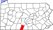 | |
| Townships | ||
| CDP | ||
| Unincorporated communities | ||