Valley, Nebraska
| Valley, Nebraska | |
|---|---|
| City | |
|
Downtown Valley: North Spruce Street | |
 Location of Valley, Nebraska | |
| Coordinates: 41°18′51″N 96°20′54″W / 41.31417°N 96.34833°WCoordinates: 41°18′51″N 96°20′54″W / 41.31417°N 96.34833°W | |
| Country | United States |
| State | Nebraska |
| County | Douglas |
| Area[1] | |
| • Total | 3.62 sq mi (9.38 km2) |
| • Land | 3.56 sq mi (9.22 km2) |
| • Water | 0.06 sq mi (0.16 km2) |
| Elevation | 1,142 ft (348 m) |
| Population (2010)[2] | |
| • Total | 1,875 |
| • Estimate (2013[3]) | 2,003 |
| • Density | 526.7/sq mi (203.4/km2) |
| Time zone | Central (CST) (UTC-6) |
| • Summer (DST) | CDT (UTC-5) |
| ZIP code | 68064 |
| Area code(s) | 402 |
| FIPS code | 31-50020 |
| GNIS feature ID | 0834325[4] |
| Website | http://www.valleyne.org/ |
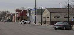
Valley is a city in Douglas County, Nebraska, United States. The population was 1,875 at the 2010 census.
Valley is also home to the area's National Weather Service office, serving portions of eastern Nebraska and southwestern Iowa.
History
Valley was laid out as a town in 1864 when it was certain that the Union Pacific Transcontinental Railroad would be extended to that point. It was named for the Platte River valley.[5]
Geography
Valley is located at 41°18′51″N 96°20′54″W / 41.31417°N 96.34833°W (41.314199, -96.348250).[6]
According to the United States Census Bureau, the city has a total area of 3.62 square miles (9.38 km2), of which, 3.56 square miles (9.22 km2) is land and 0.06 square miles (0.16 km2) is water.[1]
Demographics
| Historical population | |||
|---|---|---|---|
| Census | Pop. | %± | |
| 1880 | 42 | — | |
| 1890 | 378 | 800.0% | |
| 1900 | 534 | 41.3% | |
| 1910 | 810 | 51.7% | |
| 1920 | 764 | −5.7% | |
| 1930 | 1,039 | 36.0% | |
| 1940 | 985 | −5.2% | |
| 1950 | 1,113 | 13.0% | |
| 1960 | 1,452 | 30.5% | |
| 1970 | 1,595 | 9.8% | |
| 1980 | 1,716 | 7.6% | |
| 1990 | 1,775 | 3.4% | |
| 2000 | 1,788 | 0.7% | |
| 2010 | 1,875 | 4.9% | |
| Est. 2015 | 2,117 | [7] | 12.9% |
| U.S. Decennial Census[8] 2013 Estimate[3] | |||
2010 census
As of the census[2] of 2010, there were 1,875 people, 804 households, and 489 families residing in the city. The population density was 526.7 inhabitants per square mile (203.4/km2). There were 871 housing units at an average density of 244.7 per square mile (94.5/km2). The racial makeup of the city was 95.3% White, 1.3% African American, 0.4% Native American, 0.5% Asian, 1.1% from other races, and 1.3% from two or more races. Hispanic or Latino of any race were 4.1% of the population.
There were 804 households of which 29.6% had children under the age of 18 living with them, 44.3% were married couples living together, 11.2% had a female householder with no husband present, 5.3% had a male householder with no wife present, and 39.2% were non-families. 34.3% of all households were made up of individuals and 15.8% had someone living alone who was 65 years of age or older. The average household size was 2.26 and the average family size was 2.90.
The median age in the city was 42.3 years. 23.9% of residents were under the age of 18; 7.5% were between the ages of 18 and 24; 22.2% were from 25 to 44; 28.6% were from 45 to 64; and 17.8% were 65 years of age or older. The gender makeup of the city was 47.8% male and 52.2% female.
2000 census
As of the census of 2000, there were 1,788 people, 696 households, and 455 families residing in the city. The population density was 1,180.2 people per square mile (454.2/km²). There were 760 housing units at an average density of 501.6 per square mile (193.1/km²). The racial makeup of the city was 96.81% White, 0.56% African American, 0.50% Native American, 0.34% Asian, 0.06% Pacific Islander, 0.95% from other races, and 0.78% from two or more races. Hispanic or Latino of any race were 1.79% of the population.
There were 696 households out of which 35.5% had children under the age of 18 living with them, 50.4% were married couples living together, 10.1% had a female householder with no husband present, and 34.6% were non-families. 30.9% of all households were made up of individuals and 13.9% had someone living alone who was 65 years of age or older. The average household size was 2.49 and the average family size was 3.14.
In the city the population was spread out with 28.4% under the age of 18, 7.7% from 18 to 24, 28.4% from 25 to 44, 19.5% from 45 to 64, and 16.0% who were 65 years of age or older. The median age was 36 years. For every 100 females there were 94.3 males. For every 100 females age 18 and over, there were 92.3 males.
As of 2000 the median income for a household in the city was $36,949, and the median income for a family was $47,596. Males had a median income of $35,847 versus $24,792 for females. The per capita income for the city was $17,508. About 7.7% of families and 11.3% of the population were below the poverty line, including 14.1% of those under age 18 and 13.2% of those age 65 or over.
Education
Valley and neighboring Waterloo operate a consolidated school system, Douglas County West Community Schools. Douglas County West (DC West) was formed in August 2005 by the merger of Waterloo Public Schools and Valley Public Schools. Douglas County West provides an extensive education from pre-school through the 12th grade. DC West is unique in that it actually has two campuses. The elementary and high school are located in Valley and the pre-school and middle school are located in Waterloo. The school system provides bus services between the campuses, which simplifies matters for parents who live in one location but have a child attending classes in another. DC West High School, as it is commonly called is located at 401 S. Pine Street in Valley. This location is home to grades 9 through 12. The main structure and athletic fields, including the football field and newly renovated track, are all in close proximity to one another.
References
- 1 2 "US Gazetteer files 2010". United States Census Bureau. Retrieved 2012-06-24.
- 1 2 "American FactFinder". United States Census Bureau. Retrieved 2012-06-24.
- 1 2 "Population Estimates". United States Census Bureau. Retrieved 2014-07-17.
- ↑ "US Board on Geographic Names". United States Geological Survey. 2007-10-25. Retrieved 2008-01-31.
- ↑ "Valley, Douglas County". Center for Advanced Land Management Information Technologies. University of Nebraska. Retrieved 8 August 2014.
- ↑ "US Gazetteer files: 2010, 2000, and 1990". United States Census Bureau. 2011-02-12. Retrieved 2011-04-23.
- ↑ "Annual Estimates of the Resident Population for Incorporated Places: April 1, 2010 to July 1, 2015". Retrieved July 2, 2016.
- ↑ United States Census Bureau. "Census of Population and Housing". Retrieved June 22, 2013.
External links
- City of Valley
- Douglas County West Community Schools
- Historical images of Valley - Nebraska Memories
Municipalities and communities of Douglas County, Nebraska, United States | ||
|---|---|---|
| Cities | ||
| Villages | ||
| CDPs | ||
| Unincorporated communities | ||
| See also | ||
Metropolitan area of Omaha–Council Bluffs | ||||||||
|---|---|---|---|---|---|---|---|---|
| Primary Cities |
|  | ||||||
| Cities over 10,000 (per 2010 Census) |
| |||||||
| Cities of 5,000 to 10,000 (per 2010 Census) |
| |||||||
| Cities of 1,000 to 5,000 (per 2010 Census) |
| |||||||
| Census-designated places |
| |||||||
| Cities and villages of fewer than 1,000 (per 2010 Census) |
| |||||||
| Counties |
| |||||||