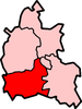
Vale of White Horse
| Vale of White Horse Vale of White Horse District | |
|---|---|
| Non-metropolitan district | |
 Vale of White Horse shown within Oxfordshire | |
| Sovereign state | United Kingdom |
| Constituent country | England |
| Region | South East England |
| Non-metropolitan county | Oxfordshire |
| Historic county |
Oxfordshire (north of River Thames) Berkshire (south of River Thames) |
| Status | Non-metropolitan district |
| Admin HQ | Abingdon |
| Incorporated | 1 April 1974 |
| Government | |
| • Type | Non-metropolitan district council |
| • Body | Vale of White Horse District Council |
| • Leadership | Leader & Cabinet (Conservative) |
| • MPs |
Nicola Blackwood Ed Vaizey |
| Area | |
| • Total | 223.4 sq mi (578.6 km2) |
| Area rank | 77th (of 326) |
| Population (mid-2014 est.) | |
| • Total | 124,852 |
| • Rank | 173rd (of 326) |
| • Density | 560/sq mi (220/km2) |
| • Ethnicity[1] |
95.6% White 1.4% S.Asian 1.2% Chinese or other 1.1% Mixed Race 0.7% Black British |
| Time zone | GMT (UTC0) |
| • Summer (DST) | BST (UTC+1) |
| ONS code |
38UE (ONS) E07000180 (GSS) |
| OS grid reference | SU3462689188 |
| Website |
www |
The Vale of White Horse is a local government district of Oxfordshire in England. Most of the district had been part of Wantage Rural District in the county of Berkshire until local government re-organisation in 1974. In 1974 the area of the rural district was split, with the parishes of Ardington, Blewbury, Childrey, Chilton, Denchworth, East Challow, East Hanney, East Hendred, Goosey, Grove, Harwell, Letcombe Bassett, Letcombe Regis, Lockinge, Sparsholt, Upton, West Challow, West Hanney and West Hendred becoming part of the Vale of White Horse district in Oxfordshire, and the rest becoming part of the Newbury district of a smaller Berkshire. The main town is Abingdon; other places include Faringdon and Wantage. There are 68 parishes within the district. Vale of White Horse District Council is located in Milton Park, Milton, and the current Leader of the Council is Matthew Barber.[2]
It is a geographically distinct region, lying between the Berkshire Downs and the River Thames, named after the Bronze Age Uffington White Horse. The district was formed on 1 April 1974, under the Local Government Act 1972, from the Municipal Borough of Abingdon, Wantage Urban District, Abingdon Rural District, Faringdon Rural District and part of the Wantage Rural District of Berkshire. The southern border of the district roughly approximates the Ridgeway Path. The area is often referred to as the ‘Vale of the White Horse’.
Geography
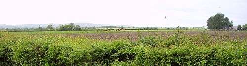
The Vale is the valley of the Ock, a stream which joins the Thames from the west at Abingdon. It is almost flat and well wooded, its green meadows and foliage contrasting richly with the bald summits of the Berkshire Downs, which flank it on the south. The numerous elm trees that once were a major feature of the Vale were lost to Dutch Elm Disease. To the north, a low ridge separates it from the upper Thames Valley, holding back the soft Jurassic sedimentary deposits (Greensand, Gault and Kimmeridge Clay) behind a hard corallian limestone escarpment ridge, in what is technically a hanging valley; but local usage sometimes extends the vale to cover all the ground between the Cotswolds (on the north) and the Berkshire Downs. According to the geographical definition, however, the Vale is from two to five miles wide, and the distance by road from Abingdon to Shrivenham at its head is 18 miles.
Wantage is the only town in the heart of the Vale (although Faringdon, on the northwestern rim, is also a "Vale" town), lying in a sheltered hollow at the foot of the hills, along which, moreover, villages are more numerous than elsewhere in the vale. There are numerous springs emanating from the chalk hills, which allowed these settlements to thrive in former times.
Sites of interest
Towards the west, above Uffington, the hills reach a culminating point of 261 m (856 ft) in White Horse Hill. In its northern flank, just below the summit, a gigantic figure of a horse is cut, the turf being removed to show the white chalky soil beneath. This figure gives name to the hill, the range and the Vale. It is 114 m (374 ft) long and highly stylised, the neck, body and tail varying little in width.

The origin of the figure is unknown. Tradition asserted it to be the monument of a victory over the Danes by King Alfred, who was born at Wantage, but the site of the Battle of Ashdown (871 CE), has been variously located. Moreover, the figure has been dated to the Bronze Age, so it pre-dates the battle by many centuries. Many ancient remains occur in the vicinity of the Horse.
On the summit of the hill there is an extensive and well-preserved circular camp, apparently used by the Romans but of much earlier origin. It is an Iron Age hill fort named Uffington Castle, after the village in the vale below. Within a short distance are Hardwell Castle, a near-square work and, on the southern slope of the hills near Ashdown House, a small camp traditionally called Alfred's Castle. Further to the West, there is Liddington Castle.

A smooth, steep gully on the north flank of White Horse Hill is called the Manger, and to the west of it rises a bald mound named Dragon Hill, the traditional scene of St George's victory over the dragon, the blood of which made the ground bare of grass for ever. But the name may derive from Celtic Pendragon ("dragon's head"), which was a title for a king, and may point to an early place of burial.
To the west of White Horse Hill lies a long barrow called Wayland's Smithy, said to be the home of a smith who was never seen, but who shod the horses of travellers if they were left at the place with payment. The legend is elaborated, and the smith appears as a character, in Sir Walter Scott's novel Kenilworth, and in Rudyard Kipling's Puck of Pook's Hill. The Vale as a whole appears at the beginning of Tom Brown's Schooldays, as the scene of innocent Saxon boyhood adventures, before the eponymous hero is sent away to school at Rugby. Rosemary Sutcliff's 1977 historical novel Sun Horse, Moon Horse takes place in the Vale, telling the tale of the White Horse's creation in ancient Celtic times.
The White Horse has been carefully cleared of vegetation from time to time. The figure has remained clear of turf throughout its long existence, except for being covered as a precaution during the Second World War. The cleaning process, known as the Scouring of the White Horse, was formerly made the occasion of a festival. Sports of all kinds were held, and keen rivalry was maintained, not only between the inhabitants of the local villages, but between local champions and those from distant parts of England. The first of such festivals known took place in 1755 and they died out only subsequently to 1857.
The Ridgeway
A grassy track represents the Ridgeway, claimed as the oldest road in Europe, perhaps five thousand years old or more. It travels along the crest of the hills, far above what would then have been marshy lowlands or forests, continuing Icknield Street, from the Chilterns to Goring and Streatley on the River Thames. It links The Wash and Salisbury Plain, and would have been an important artery for trade.
Other earthworks, in addition to those near the White Horse, overlook the Vale, such as Letcombe Castle (also known as Segsbury Camp) above Wantage. At the foot of the hills, not far east of the Horse, is preserved the so-called Blowing Stone of Kingston Lisle, a mass of sandstone (a sarsen) pierced with holes in such a way that, when blown like a trumpet, it produces a loud note. It is believed that, in earlier times, the stone served the purpose of a bugle.
Several of the village churches in the Vale are of interest, notably the fine Early English cruciform building at Uffington, that has a hexagonal tower and is known as The Cathedral of the Vale.[3]
Economy

The Vale used to have a thriving dairy industry, especially in the 1960s. That has dwindled to just a few herds of dairy cows, in the first years of the 21st century. Farming is now mostly arable.
Natural mineral resources are mined (quarried) in the Vale. These include sand, gravel and (formerly) Fuller's Earth.
With the closure of the MG works at Abingdon, there is no motor industry, apart from some specialist car makers and component factories. Macdermid Autotype in Wantage remains one of the few large industrial employers in the region.
The length of the Vale is traversed by the Great Western Main Line and the Cherwell Valley Line. Appleford railway station and Radley railway station are now the only stations within the Vale, although there used to be stations at Challow, Uffington, Grove (near Wantage), Abingdon and Steventon. These all closed as part of the Beeching cuts, in the early 1960s. The nearest main line stations are now Swindon, Oxford and Didcot Parkway.
At one time Amey plc had its head office in Sutton Courtenay, Vale of White Horse.[4]
See also
- Pendon Museum – the main exhibit is an extensive model featuring scale replicas of buildings from the Vale.
- Vale of the Red Horse – another vale of a similar name that once carried some 1, 2, 3, 4 or 5 hill figures of a horse.
Notes
- ↑ "Resident Population Estimates by Ethnic Group, Vale of White Horse". Office for National Statistics.
- ↑ "Councillor details – Councillor Matthew Barber". Vale of White Horse District Council.
- ↑ Nash Ford, David. "Uffington: St. Mary's Church". Berkshire History. Retrieved 9 February 2016.
- ↑ "Amey bids for high-flying firm". Oxford Mail. 22 January 1999. Retrieved 9 February 2016.
References
| Wikisource has the text of the 1911 Encyclopædia Britannica article White Horse, Vale of. |
- Thomas Hughes, The Scouring of the White Horse (1859).
- G. K. Chesterton, "The Ballad of the White Horse" (1911).
- Rudyard Kipling, "Puck of Pook's Hill".
- Tom Brown's Schooldays
Oxfordshire Portal | |
| Boroughs or districts | |
| Major settlements | |
| Topics | |
Coordinates: 51°36′N 1°30′W / 51.6°N 1.5°W