Valdez, Florida
| Valdez | |
|---|---|
| Unincorporated community | |
 Valdez | |
| Coordinates: 28°50′43″N 081°19′20″W / 28.84528°N 81.32222°WCoordinates: 28°50′43″N 081°19′20″W / 28.84528°N 81.32222°W | |
| Country |
|
| State |
|
| County | Volusia |
| Elevation | 16 ft (5 m) |
| Time zone | Eastern (EST) (UTC-5) |
| • Summer (DST) | EDT (UTC-4) |
| enter ZIP code | 32713 |
| Area code(s) | 386 |
| GNIS feature ID | 292722[1] |
Valdez is an unincorporated community[2] located in southwest Volusia County, Florida, within the city limits of DeBary. Valdez is located along U.S. Highway 17-92 (Charles Richard Beall Blvd.) where it intersects with Barwick Road, just north of the St. Johns River.
History
Valdez was named in honor of Antonio Valdez, the secretary of the Spanish navy in 1787, when the Spanish explored the area.[3] He chose one of his protégés, Lt. Jose del Rio Cossa, to conduct an exploratory survey of Florida's naval store resources. In this survey, Cossa created an enormous map in which he renamed Lake George (now Lake Monroe) to Laguana Valdez. Although this name did not persist, pre-American land deeds referred to what is now Lake Monroe as Valdez.[4]
In 1928, Florida Power & Light began constructing a power plant in Valdez on the north shore of the St. Johns river.[3]
_Florida_1826.jpg)
References
- ↑ "US Board on Geographic Names". United States Geological Survey. 2007-10-25. Retrieved 2008-01-31.
- ↑ "Geographic Names Information System". USGS. Retrieved 25 August 2011.
- 1 2 Koslow, Bob (7 August 2001). "Big City People Escape to a Small Town". Daytona Beach News-Journal.
- ↑ Franke, Arthur E., Jr. (1986). Volusia: The West Side. DeLand, Florida: West Volusia Historical Society. pp. 373–374.
Municipalities and communities of Volusia County, Florida, United States | ||
|---|---|---|
| Cities | 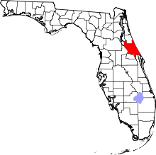 | |
| Towns | ||
| CDPs | ||
| Unincorporated communities | ||
| Footnotes | ‡This populated place also has portions in an adjacent county or counties | |