Val-d'Or
| Val-d'Or | |
|---|---|
| City | |
|
Val-d'Or city | |
 Location within La Vallée-de-l'Or RCM. | |
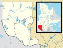 Val-d'Or Location in western Quebec. | |
| Coordinates: 48°06′N 77°47′W / 48.100°N 77.783°WCoordinates: 48°06′N 77°47′W / 48.100°N 77.783°W[1] | |
| Country |
|
| Province |
|
| Region | Abitibi-Témiscamingue |
| RCM | La Vallée-de-l'Or |
| Constituted | January 1, 2002 |
| Government[2] | |
| • Mayor | Pierre Corbeil |
| • Federal riding |
Abitibi—Baie-James— Nunavik—Eeyou |
| • Prov. riding | Abitibi-Est |
| Area[2][3] | |
| • City | 3,955.10 km2 (1,527.07 sq mi) |
| • Land | 3,551.79 km2 (1,371.35 sq mi) |
| • Metro[4] | 3,555.03 km2 (1,372.60 sq mi) |
| Elevation | 306 m (1,004 ft) |
| Population (2011)[3] | |
| • City | 31,862 |
| • Density | 9.0/km2 (23/sq mi) |
| • Metro[4] | 33,265 |
| • Metro density | 9.4/km2 (24/sq mi) |
| • Pop 2006-2011 |
|
| • Dwellings | 14,784 |
| Time zone | EST (UTC−5) |
| • Summer (DST) | EDT (UTC−4) |
| Postal code(s) | J9P |
| Area code(s) | 819/873 |
| Highways |
|
| Website |
www |
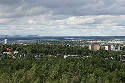
Val-d'Or (French pronunciation: [vald‿ɔʁ], local pronunciation: [vald‿ɑɔ̯ʁ]) is a city in Quebec, Canada with a population of 31,862 inhabitants according to the Canada 2011 Census. The city is located in the Abitibi-Témiscamingue region near La Vérendrye Wildlife Reserve.
History
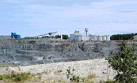
Gold was discovered in the area in 1923. The name of the town is French for "Valley of Gold." While gold is still mined in the area today, base metals, such as copper (Cu), zinc (Zn), and lead (Pb) have become increasingly important resources. The ore is usually found in volcanic rocks that were deposited on the sea floor over 2.7 billion years ago. They are referred to as volcanic-hosted (or volcanogenic) massive sulphide deposits (VMS).[1]
The city is known for its vast parks, cycle tracks, and forests. Some other attractions include the City of Gold and the mining village of Bourlamaque, which were officially proclaimed historic sites in 1979.
The city hosted the Quebec Games in 1987. The local hockey team, the Val-d'Or Foreurs, have played in the QMJHL since 1993, winning the league championship in 1998, 2001 and 2014 to claim a spot in the Memorial Cup. They play at Centre Air Creebec. The Foreurs' mascot is called Dynamit, named after dynamite which was extensively used by the mining industry of Val-d'Or.
Val-d'Or was once home to CFS Val-d'Or, a Canadian Forces Station.
In the municipal reorganizations of January 1, 2002, Val-d'Or was merged with the neighbouring municipalities of Dubuisson, Sullivan, Val-Senneville and Vassan.[1]
The Radio-Canada investigative television program, Enquête, revealed in October 2015 numerous allegations of assault and sexual abuse of local aboriginal women by members of the provincial police, the Sûreté du Québec.[5] The news propelled the town into the national spotlight, causing Québec's Public Safety Minister, Lise Thériault, to suspend the officers and launch an independent investigation led by the Montréal police force.[6]
Demographics
Population:
- Population in 2011:31,862
- 2006 to 2011 population change: +2.4 %
- Population in 2006: 31,123
- Population total in 2001: 31,430
- Dubuisson: 1,686
- Sullivan: 3,529
- Val-d'Or: 22,748
- Val-Senneville: 2,479
- Vassan: 988
- Population in 1996:
- Dubuisson: 1,655
- Sullivan: 3,312
- Val-d'Or: 24,479
- Val-Senneville: 2,408
- Vassan: 988
Private dwellings (occupied by usual residents): 13,960
Languages spoken:
- English only: 0.4%
- French only: 67.8%
- French and English: 31.8%
- Other only: 0.05%
City council
City council is:[2]
- Mayor: Pierre Corbeil
- Councillors: Gilles Bérubé, Céline Brindamour, Bernard Gauthier, Lorraine Morissette, Francis Murphy, Pierre Potvin, Michael Prince, Robert Quesnel
Media
Almost all media in Val-d'Or and the nearby city of Rouyn-Noranda serves both cities. Although the cities are far enough apart that radio and television stations in the area serve the cities from separate transmitters, almost every broadcast station in either city has a rebroadcaster in the other city. The only nominal exceptions are the cities' separate NRJ stations, although at present even these stations share the majority of their broadcast schedule.
Economy
Val-d'Or Airport is served by several airlines. Air Creebec, a regional airline, has its headquarters in Val-d'Or.[7]
Val-d'Or's proximity to the Abitibi gold belt has made it a large gold producer, being part of a region that produced 45 million ounces of gold since the 1930s.[8][9]
In 2012, Quebec Lithium Corp. re-opened a lithium mine which had operated as an underground mine from 1955–65, planning to carve an open pit mine over pegmatite dikes. the mine is about 60 kilometres (37 mi) north of Val d'Or, 38 kilometres (24 mi) southeast of Amos, and 15 kilometres (9.3 mi) km west of Barraute. Access to the mine is via paved road from Val d'Or.[10]
Geography
Val-d’Or is situated on the Canadian Shield at an elevation of 1100 feet (330m) above sea level. Although its name refers to a valley (“Val”), the city is actually situated on a vast, slightly undulating plain.
Val-d’Or is at the heart of a vast hydrographic network which includes to the north Lake Blouin, the head water of the Harricana River and to the south Baie Carrière, a reservoir which feeds the Ottawa River.[11]
Climate
Val-d'Or has a humid continental climate that closely borders on a subarctic climate (Köppen Dfb/Dfc). Winters are cold and snowy with a January mean of −17.4 °C (0.7 °F). There are 18.4 days were the temperature will fall below −30 °C (−22.0 °F) although with the wind chill factored in, it can occasionally drop below −40 °C (−40.0 °F).[12] Snowfall totals are heavy, averaging 288 centimetres (113 in) with snow reliable snow cover from November to April.[12] Summers are warm with a July high of 23.7 °C (74.7 °F) though highs can reach above 30.0 °C (86.0 °F) 4.3 days. Val-d'Or receives 905 millimetres (36 in) of precipitation per year which is fairly evenly distributed throughout the year. Val-d'Or receives 1853 hours of sunshine per or about 39.5 of possible daylight hours, ranging from a low of 19.2 % in November to a high of 52.9% in July.
| Climate data for Val-d'Or (1981−2010) | |||||||||||||
|---|---|---|---|---|---|---|---|---|---|---|---|---|---|
| Month | Jan | Feb | Mar | Apr | May | Jun | Jul | Aug | Sep | Oct | Nov | Dec | Year |
| Record high humidex | 10.6 | 11.9 | 17.9 | 29.0 | 39.3 | 46.0 | 47.9 | 41.5 | 39.9 | 31.5 | 20.8 | 16.2 | 47.9 |
| Record high °C (°F) | 9.7 (49.5) |
12.3 (54.1) |
25.0 (77) |
28.2 (82.8) |
32.8 (91) |
34.0 (93.2) |
36.1 (97) |
36.1 (97) |
32.2 (90) |
26.1 (79) |
18.3 (64.9) |
13.7 (56.7) |
36.1 (97) |
| Average high °C (°F) | −10.9 (12.4) |
−7.9 (17.8) |
−1.5 (29.3) |
7.2 (45) |
15.9 (60.6) |
21.1 (70) |
23.7 (74.7) |
21.9 (71.4) |
16.0 (60.8) |
8.9 (48) |
0.2 (32.4) |
−7.0 (19.4) |
7.3 (45.1) |
| Daily mean °C (°F) | −17.4 (0.7) |
−14.7 (5.5) |
−8.1 (17.4) |
1.4 (34.5) |
9.2 (48.6) |
14.6 (58.3) |
17.5 (63.5) |
15.9 (60.6) |
10.5 (50.9) |
4.4 (39.9) |
−4.1 (24.6) |
−12.5 (9.5) |
1.4 (34.5) |
| Average low °C (°F) | −23.9 (−11) |
−21.4 (−6.5) |
−14.7 (5.5) |
−4.5 (23.9) |
2.5 (36.5) |
7.9 (46.2) |
11.3 (52.3) |
9.8 (49.6) |
5.0 (41) |
−0.2 (31.6) |
−8.3 (17.1) |
−18.0 (−0.4) |
−4.5 (23.9) |
| Record low °C (°F) | −43.9 (−47) |
−42.2 (−44) |
−36.1 (−33) |
−26.1 (−15) |
−11.1 (12) |
−3.9 (25) |
−0.1 (31.8) |
−2.8 (27) |
−6.2 (20.8) |
−13.3 (8.1) |
−30.0 (−22) |
−40.6 (−41.1) |
−43.9 (−47) |
| Record low wind chill | −55.2 | −53.5 | −47.2 | −32.8 | −18.7 | −9.2 | 0.0 | −2.9 | −10.0 | −18.3 | −36.0 | −50.1 | −55.2 |
| Average precipitation mm (inches) | 51.7 (2.035) |
39.3 (1.547) |
58.6 (2.307) |
66.4 (2.614) |
85.1 (3.35) |
90.4 (3.559) |
97.4 (3.835) |
93.5 (3.681) |
94.8 (3.732) |
83.7 (3.295) |
83.9 (3.303) |
60.4 (2.378) |
905.1 (35.634) |
| Average rainfall mm (inches) | 5.6 (0.22) |
4.2 (0.165) |
16.5 (0.65) |
35.3 (1.39) |
82.3 (3.24) |
90.3 (3.555) |
97.4 (3.835) |
93.5 (3.681) |
93.3 (3.673) |
70.8 (2.787) |
40.9 (1.61) |
9.4 (0.37) |
639.4 (25.173) |
| Average snowfall cm (inches) | 52.2 (20.55) |
39.6 (15.59) |
44.3 (17.44) |
29.9 (11.77) |
2.6 (1.02) |
0.07 (0.028) |
0.0 (0) |
0.0 (0) |
1.5 (0.59) |
12.6 (4.96) |
46.6 (18.35) |
58.8 (23.15) |
288.1 (113.43) |
| Average precipitation days (≥ 0.2 mm) | 18.3 | 15.6 | 14.4 | 13.8 | 14.3 | 14.4 | 15.1 | 14.5 | 16.6 | 17.8 | 20.6 | 21.4 | 196.8 |
| Average rainy days (≥ 0.2 mm) | 2.1 | 1.5 | 4.0 | 8.9 | 13.7 | 14.4 | 15.3 | 14.4 | 16.6 | 13.8 | 7.7 | 2.7 | 115.1 |
| Average snowy days (≥ 0.2 cm) | 18.2 | 14.9 | 12.6 | 8.3 | 1.7 | 0.27 | 0.0 | 0.0 | 1.0 | 6.9 | 16.3 | 20.9 | 101.0 |
| Mean monthly sunshine hours | 86.5 | 124.4 | 162.3 | 177.8 | 220.7 | 243.0 | 255.9 | 227.2 | 139.9 | 99.0 | 53.7 | 62.9 | 1,853.4 |
| Percent possible sunshine | 31.5 | 43.3 | 44.1 | 43.5 | 47.0 | 50.7 | 52.9 | 51.3 | 37.0 | 29.4 | 19.2 | 24.0 | 39.5 |
| Source: Environment Canada[12] | |||||||||||||
References
- 1 2 3 "Val-d'Or (Ville)" (in French). Commission de toponymie du Québec. Retrieved 2010-12-03.
- 1 2 3 Ministère des Affaires municipales, des Régions et de l'Occupation du territoire - Répertoire des municipalités: Val-d'Or
- 1 2 "Val-d'Or census profile". 2011 Census data. Statistics Canada. Retrieved 2012-05-24.
- 1 2 "Val-d'Or (Census agglomeration) census profile". 2011 Census data. Statistics Canada. Retrieved 2012-05-24.. The census agglomeration consists of Val-d'Or and Lac-Simon. This was unchanged from the 2006 census.
- ↑ "Aboriginal women's claims of police sex abuse under investigation". CBC News. Retrieved 2015-10-29.
- ↑ "Quebec police officers put on leave pending sex abuse investigation". CBC News. Retrieved 2015-10-29.
- ↑ "Contact Us." Air Crebeec. Retrieved on May 29, 2009.
- ↑ "titan resources plans exploration of abitibi gold belt, val d'or property". 2010-02-10.
- ↑ "malartic val d'or projects". Retrieved 2010-05-03.
- ↑ "Quebec Lithium". Canada Lithium Corp. Retrieved 2013-03-07.
- ↑ http://www.ourroots.ca/e/page.aspx?id=806869
- 1 2 3 "Val-D'Or A". Canadian Climate Normals 1981–2010. Environment Canada. Retrieved November 6, 2013.
External links
| Wikimedia Commons has media related to Val-d'Or. |
- Municipal website (French)
- Cité de l'Or website
- Attractions of the Abitibi-Temiscamingue
- Le Tour de l'Abitibi website
 |
La Motte Rivière-Héva |
La Corne, Barraute, Belcourt | Senneterre (parish) | |
| Malartic Lac-Fouillac Rouyn-Noranda |
|
Senneterre (city) | ||
| ||||
| | ||||
| Les Lacs-du-Témiscamingue, Lac-Granet, Matchi-Manitou, Réservoir-Dozois | Lac-Metei |
| Cities | |
|---|---|
| Municipalities | |
| Parishes | |
| Unorganized territories | |
| |