Vågsøy
| Vågsøy kommune | |||
|---|---|---|---|
| Municipality | |||
 | |||
| |||
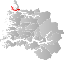 Vågsøy within Sogn og Fjordane | |||
| Coordinates: 61°55′16″N 05°11′37″E / 61.92111°N 5.19361°ECoordinates: 61°55′16″N 05°11′37″E / 61.92111°N 5.19361°E | |||
| Country | Norway | ||
| County | Sogn og Fjordane | ||
| District | Nordfjord | ||
| Administrative centre | Måløy | ||
| Government | |||
| • Mayor (2011) | Morten Andreas Hagen (H) | ||
| Area | |||
| • Total | 176.50 km2 (68.15 sq mi) | ||
| • Land | 171.13 km2 (66.07 sq mi) | ||
| • Water | 5.37 km2 (2.07 sq mi) | ||
| Area rank | 348 in Norway | ||
| Population (2013) | |||
| • Total | 6,119 | ||
| • Rank | 171 in Norway | ||
| • Density | 35.8/km2 (93/sq mi) | ||
| • Change (10 years) | -3.6 % | ||
| Demonym(s) | Vågsøyværing[1] | ||
| Time zone | CET (UTC+1) | ||
| • Summer (DST) | CEST (UTC+2) | ||
| ISO 3166 code | NO-1439 | ||
| Official language form | Nynorsk | ||
| Website |
www | ||
|
| |||


Vågsøy is a municipality in Sogn og Fjordane county, Norway. It is located in the traditional district of Nordfjord. The municipality's administrative center is the town Måløy. Other population centers in Vågsøy include the villages of Bryggja, Deknepollen, Holvika, Kvalheim, Langeneset, Raudeberg, Refvika, Silda, Tennebø, Totland, Vedvika, and Vågsvåg. The municipality includes the island of Vågsøy, several small surrounding islands, and part of the mainland.
The municipality of Vågsøy is the second largest fishing municipality in Norway, and is home to one of Norway's most modern fish-processing plants.[2]
General information
Historically, Vågsøy was part of Selje Municipality. On 1 January 1910, the municipality of Selje was split into three separate municipalities: Nord-Vågsøy (population: 1,111); Sør-Vågsøy (population: 1,517); and Selje (population: 3,367). Nord-Vågsøy included the northern half of the island of Vågsøy and Sør-Vågsøy included the southern part of the island.[3]
On 1 January 1964, the new municipality of Vågsøy was created by merging the following areas together:
- Nord-Vågsøy municipality (population: 1,476)
- Sør-Vågsøy municipality (population: 3,926)
- from Selje: the island of Silda, the Hagevik-Osmundsvåg area, and Sørpoll (population: 344)
- from Davik: the islands of Husevågøy, Grindøy, Gangsøy, and Risøy; and all of Davik that was north of the Nordfjorden and west of Lefdal (population: 1,216)
The new municipality had an initial population of 6,962.[3][4]
Name
The municipality is named after the island of Vågsøy. The Old Norse form of the name was Vágsøy. The first element is the genitive case of vágr which means "bay" and the last element is øy which means "island".
Coat-of-arms
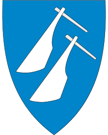
The Coat of arms of Vågsøy is of modern design. The coat of arms was granted on 27 March 1987. The arms show two rudders, used in the one-man boats which have been used for a long time in the village. The rudders are silver and the background is blue.[5]
Churches
The Church of Norway has one parish (sokn) within the municipality of Vågsøy. It is part of the Nordfjord deanery in the Diocese of Bjørgvin.
| Parish (Sokn) | Church Name | Location of the Church | Year Built | |
|---|---|---|---|---|
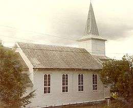
| Vågsøy | Nord-Vågsøy Church | Raudeberg | 1960 | |
| Sør-Vågsøy Church | Måløy | 1907 | ||
| Totland Church | Totland | 1912 | ||
| *The 3 sokns were merged into 1 sokn in 2001. Sør-Vågsøy church is the main parish church. | ||||
Government
All municipalities in Norway, including Vågsøy, are responsible for primary education (through 10th grade), outpatient health services, senior citizen services, unemployment and other social services, zoning, economic development, and municipal roads. The municipality is governed by a municipal council of elected representatives, which in turn elect a mayor.
Municipal council
The municipal council (Kommunestyre) of Vågsøy is made up of 27 representatives that are elected to every four years. For 2011–2015, the party breakdown is as follows:[6]
| Party Name | Name in Norwegian | Number of representatives | |
|---|---|---|---|
| Labour Party | Arbeiderpartiet | 3 | |
| Progress Party | Framstegspartiet | 4 | |
| Conservative Party | Høgre | 8 | |
| Christian Democratic Party | Kristelig Folkeparti | 2 | |
| Centre Party | Senterpartiet | 4 | |
| Socialist Left Party | Sosialistisk Venstreparti | 1 | |
| Liberal Party | Venstre | 4 | |
| Local Lists | Lokale lister | 1 | |
| Total number of members: | 27 | ||
Mayor
The mayor (ordførar) of a municipality in Norway is a representative of the majority party of the municipal council who is elected to lead the council. Morten Andreas Hagen of the Conservative Party was elected mayor for the 2011–2015 term.
In 2007, Vågsøy participated in a trial where the mayor was directly elected. The sitting mayor, Roger B. Silden, received 44.1% of the votes and won the election. His party (the Norwegian Labour Party), however, did poorer than in 2003 and it became the second largest party with only 21.8% of the votes.
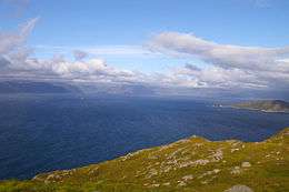
Geography
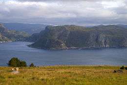

Vågsøy is made up of the mainland and islands on the northern and outer shore of the Nordfjorden. The municipality is named after its largest island, Vågsøy. Other populated islands in Vågsøy include Silda, Moldøen, and Husevågøy. The lake Degnepollvatnet is located between the villages of Degnepoll and Tennebø.
The municipalities of Selje (in Sogn og Fjordane county) and Vanylven (in Møre og Romsdal county) border to the north, the municipality of Eid lies to the east, the municipality of Bremanger lies to the south, and the North Sea borders Vågsøy to the west.
Attractions
Måløy
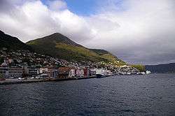
Måløy attained city status in 1997. It lies along the Ulvesundet strait on the island of Vågsøy, and is joined to the mainland by the 1,224-metre (4,016 ft) long Måløy Bridge, a structure that forms a gateway for all seagoing traffic. The Coastal Steamer (Hurtigruten) has daily departures.[2] The old part of the city lies on the island of Moldøen.
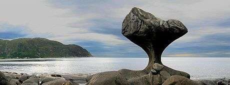
Kannestein
Over thousands of years, ocean waves have ground the rock to the shape it has today. It is located in the village of Oppedal, approximately 10 kilometres (6.2 mi) west of the center of Måløy. Every year many visitors come to Oppedal to take a closer look at the stone. The Kannestein or Kanne Stone was formed by loose stones and the pounding of the waves over a period of thousands of years, and stands today as a 4 to 5 metres (13 to 16 ft) high, narrow-footed rock. This is caused by stones having split loose, which have knocked and gnawed at the rockface until they have become polished and rounded. Loose stones have then worked themselves deeper into the rock. New stones have come, and in time the potholes have become deeper and wider. Several potholes near to each other have been polished for so long that the sides have been rubbed away, leaving just the middle section, such as the Kanne Stone.[2]
Vågsberget trading post
In 1636, trader Didrik Fester from Bergen came to Vågsberget to open a trading business. There was probably trading activity and an inn before Fester’s arrival, and the trading post at Vågsberget has changed hands several times throughout the years. Restoration work is being carried out on Vågsberget,[7] but the café and exhibition is open in summer and guided tours are available. There is also an exhibition featuring old fishing boats and equipment.[2] Vågsberget is now part of the large village of Vågsvåg.
Silda
Silda, the island in Sildagapet bay, is an old fishing community, which in its heyday had a population of 150 who made a living from fishing and farming. Its current winter population is only about 30, while in summer it is host to several hundred people, staying in holiday houses and cabins. The island has a restaurant perched on a rock out in the southern harbor. There are also cabins for rent there. The jetty in Silda’s northern harbor was started in the 1860s and completed in the 20th century. With the exception of a few tractors, the island is "car free", but it has cycling and walking tracks, footpaths and walking terrain. A regular boat service runs to and from Måløy several times a day.[2]
Lighthouses
Vågsøy municipality has four lighthouses. Three of them are open daily and are available for let for short or long periods.[2]
- Kråkenes Lighthouse is a working lighthouse and also a weather station that collects important information. Kråkenes lighthouse, which offers views of the ocean at Stadhavet, lies at the most northerly point on the island of Vågsøy and is accessible by road.
- Skongenes Lighthouse is an automatic lighthouse with no road access. It is a one-hour walk from Langeneset in easy hiking terrain. There are also views towards Stadlandet. Ytre Nordfjord Turlag runs this lighthouse and offers overnight accommodation and day visits.
- Hendanes Lighthouse is an automatic lighthouse on the west side of the Torskanger inlet. It is located a short walk from the road and offers views of Stadhavet and Klovningen.
- Ulvesund Lighthouse is a lighthouse located south of Stadlandet, about 10 kilometres (6.2 mi) north of Måløy. It was built in 1870, and was manned until 1985 when it was automated.
Beaches
Refviksanden Beach is a 1.5 kilometres (0.93 mi) long beach. Refvika is approximately 10 kilometres (6.2 mi) from Måløy.[2]
See also
References
- ↑ "Navn på steder og personer: Innbyggjarnamn" (in Norwegian). Språkrådet. Retrieved 2015-12-01.
- 1 2 3 4 5 6 7 "Vågsøy Kommune". GoNorway.no. Retrieved 23 June 2008.
- 1 2 Jukvam, Dag (1999). "Historisk oversikt over endringer i kommune- og fylkesinndelingen" (PDF) (in Norwegian). Statistics Norway.
- ↑ Natvik, Oddvar (9 February 2005). "Some historical data on the 26 Kommunes". Retrieved 23 June 2008.
- ↑ Hartemink, Ralf (1996). "Norske Kommunevåpen". Retrieved 23 June 2008.
- ↑ "http://www.regjeringen.no/krd/html/valg2011/bk2_14_39.html". Ministry of Local Government and Regional Development. Retrieved 11 February 2012. External link in
|title=(help) - ↑ Vågsberget Handelsstad
External links
- NRK: Vågsøy Kommune
- Official Site of Vågsøy Municipality
- Tourist information from Vågsøy
- Silda
 Media related to Vågsøy at Wikimedia Commons