Vågsøy (island)
 Location in Sogn og Fjordane county | |
| Geography | |
|---|---|
| Location | Sogn og Fjordane, Norway |
| Coordinates | 61°58′09″N 5°05′00″E / 61.9693°N 5.0832°ECoordinates: 61°58′09″N 5°05′00″E / 61.9693°N 5.0832°E |
| Area | 59.1 km2 (22.8 sq mi) |
| Length | 12.5 km (7.77 mi) |
| Width | 9.5 km (5.9 mi) |
| Highest elevation | 613 m (2,011 ft) |
| Highest point | Veten |
| Administration | |
| County | Sogn og Fjordane |
| Municipality | Vågsøy Municipality |
Vågsøy is an island in Vågsøy Municipality in Sogn og Fjordane county, Norway. The 59.1-square-kilometre (22.8 sq mi) island lies on the northern side of the mouth of the Nordfjorden, the sixth longest fjord in Norway. The Stadlandet peninsula lies to the north of the island, the islands of Silda and Barmøya and the mainland lie to the east of the island, the island of Husevågøy lies to the south (in the middle of the mouth of the Nordfjorden), and the open ocean lies to the west. Since the island lies along the open ocean, which can be rough, there are several lighthouses along the coastline of the island including: Hendanes Lighthouse, Kråkenes Lighthouse, and Skongenes Lighthouse. The highest point on the island is the 613-metre (2,011 ft) tall Veten.[1]
The island is connected to the mainland by the Måløy Bridge. The main population centre on the island is the town of Måløy, which is also the administrative centre for the municipality. Other population centres are the villages of Raudeberg, Kvalheim, Langenes, Refvik, Vågsvåg, and Vedvik. The population (2001) of the whole island was 4,207.[1] There are 2 churches on the island: Nord-Vågsøy Church in Raudeberg and Sør-Vågsøy Church in Måløy.
Media gallery
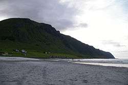 View of the Refvik beach
 Looking north, Måløy on Vågsøy island is to the left
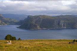 Looking south from Kvalheim towards Hendanes Lighthouse
 Kannesteinen rock, along the shore of Vågsøy
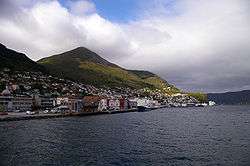 The town of Måløy
See also
References
- 1 2 Store norske leksikon. "Vågsøy – øy i Nordfjord" (in Norwegian). Retrieved 2013-09-16.