Ubsunur Hollow
| Ubsunur Hollow Uvs Lake Basin | |
|---|---|
| Name as inscribed on the World Heritage List | |
|
Ubsunur Hollow view from space (Landsat-7, 2002-08-08) | |
| Type | Natural |
| Criteria | ix, x |
| Reference | 769 |
| UNESCO region | Asia |
| Inscription history | |
| Inscription | 2003 (27th Session) |


Ubsunur Hollow (also Uvs Nuur Basin or Uvs Lake Basin; Mongolian: Увс нуурын хотгор, Uws núrīn hotgor) is a fragile mountain endorheic basin or hollow located on the territorial border of Mongolia and the Republic of Tuva in the Russian Federation, named after Uvs Lake, a large, shallow and very saline lake in the basin's center. Several smaller lakes are scattered throughout.[1] It is part of a combination of raised lands and hollows located throughout the Tannu-Ola and Altai mountainous regions. Here, the world's most northern desert meets the Northern Hemisphere's most southern tundra zone. The Ubsunur Hollow was inscribed on the World Heritage Site in 2003.
The total area of Uvs Lake drainage basin is 70,000 km2. The greater part of it lies in Mongolia (Khövsgöl, Zavkhan and Uvs Provinces), and the northern part in Russia (Tuva).
Archeology
Ubsunur Hollow's importance lies chiefly in its cultural heritage and it is the most important place in Central Asia for its concentration of unstudied archeological artifacts, especially its burial mounds, rock carvings, and stone sculptures, which are remnants of medieval settlements and Buddhist temples. There are as many as 20,000 burial mounds, many of them being older than the Egyptian pyramids.[2]
Ubsunur Hollow was nominated as a World Heritage Site in 1995 as "one of the largest intact watersheds in Central Asia where 40,000 archaeological sites can be found from historically famous nomadic tribes such as the Scythians, the Turks and the Huns."[3] (See List of World Heritage Sites in Mongolia)
Animal life

The hollow is located on the border between Mongolia and Russia and has an area of just over 10,000 km2.[4] The terrain encompasses a wide variation of climates, including glaciers, alpine tundra, sub-alpine meadows, and vast mountain taiga areas. There are also forested steppes, treeless steppes, semi-arid deserts, and ever-shifting sand dunes. It is a scenic and highly diversified natural habitat.[5]
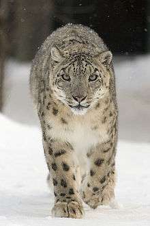
Due to its location on the cusp of the Siberian and Central Asian-Mongolian terrains, the flora and fauna of the hollow exhibit a high biodiversity for mid-latitudes. Animal species that inhabit both mountains and tundra, such as the Siberian roe deer, and Altai snowcock, flourish here. The endangered snow leopard is also present, as well as taiga dwellers such as the Caspian red deer, lynx and wolverine. Steppe dwellers include the Mongolian lark, demoiselle crane and long-tailed Siberian squirrel. Desert inhabitants include the bustard and midday gerbil. The bird species alone number some 359. Since the hollow is a protected area, many ancient species extinct in other regions have found refuge here.[5]
Population
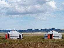
The population density is low in the Ubsunur Hollow. The lack of industry and the reliance of the inhabitants on traditional ways of life, such as nomadic pasturing, have had little impact on the landscape and have allowed the ecosystem to remain relatively free from the negative effects that human presence can impose.[5] Both the Russian[6] and the Mongolian parts of the hollow are home to nomadic herders.
Notes
- ↑ "Uvs Nuur Basin in Mongolia". Nasa.gov. Retrieved 2008-02-07.
- ↑ "The Ubsunur Hollow". Greenpeace. Retrieved 2008-02-07.
- ↑ "Russia's First World Heritage Site". Retrieved 2006-12-31.
- ↑ "Uvs Nuur Basin, Russian Federation (Tuva) & Mongolia". United Nations Environment Programme. Archived from the original on 2007-09-29. Retrieved 2008-02-05.
- 1 2 3 "The Ubsunur Hollow". Greenpeace. Retrieved 2006-12-31.
- ↑ "The Uvs Nuur Basin: Russian-Mongolian cooperation for Conservation of the World Heritage]". unesco. Retrieved 2008-02-05.
External links
- The Ubsunur Hollow
- Ubsu-Nur Accepted into World Network of Biosphere Reserves
- Singing Stones - The Republic of Tuva
- Ubsu Nur satellite photo
- Federation Legislative Survey: June 1990-December 1993
- Surveying the Lop Nor
- Ubsu Nur satellite photo
- Uvs Nuur Basin at Natural Heritage Protection Fund website
| ||


Coordinates: 50°16′30″N 92°43′11″E / 50.275°N 92.7197°E