Uttarkashi district
| Uttarkashi district उत्तरकाशी जिला Uttar Kashi | |
|---|---|
| District | |
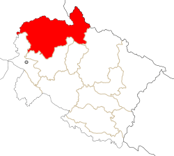 Location in Uttarakhand, India | |
| Coordinates: 30°44′N 78°27′E / 30.73°N 78.45°ECoordinates: 30°44′N 78°27′E / 30.73°N 78.45°E | |
| Country |
|
| State | Uttarakhand |
| Division | Garhwal |
| Headquarters | Uttarkashi |
| Area1451 km2claimed by China | |
| • Total | 8,016 km2 (3,095 sq mi) |
| Population | |
| • Total | 329,686 |
| • Density | 41/km2 (110/sq mi) |
| Languages | |
| • Official | Hindi |
| Time zone | IST (UTC+5:30) |
| Vehicle registration | UK |
| Website |
uttarkashi |
Uttarkashi District is a district of Garhwal division of the Uttarakhand state in northern India, and has its headquarters at Uttarkashi city. It has six Tehsils named after Barkot, Bhatwadi, Chinyali Saur, Dunda, Purola, Mori.
Uttarkashi District town lies high in the Himalaya range, and the district contains the source of both the Ganges and Yamuna rivers, which attract thousands of Hindu pilgrims. The town lies on the main route to Gangotri, has many Hindu temples, and is also considered an important Hindu pilgrimage centre. The district is bounded on the north by Himachal Pradesh state, on the northeast by Tibet, on the east by Chamoli District, on the southeast by Rudraprayag District, on the south by Tehri Garhwal District, and on the west by Dehradun District.
Assembly Constituencies
- Purola (SC)
- Yamunotri
- Gangotri
Demographics
According to the 2011 census Uttarkashi district has a population of 329,686,[1] roughly equal to the nation of Belize.[2] This gives it a ranking of 567th in India (out of a total of 640).[1] The district has a population density of 41 inhabitants per square kilometre (110/sq mi) .[1] Its population growth rate over the decade 2001-2011 was 11.75%.[1] Uttarkashi has a sex ratio of 959 females for every 1000 males,[1] and a literacy rate of 75.98%.[1]
Bhaironghati
| Bhaironghati | |
|---|---|
| City | |
| Country |
|
| State | Uttarakhand |
| District | Uttarkashi |
| Elevation | 2,806 m (9,206 ft) |


Bhaironghati is a small settlement at the juncture of the Jadh Ganga and Bhagirathi Rivers in the mountains of northern India. It is located in the Uttarkashi district of the Indian state Uttarakhand. Set between the river banks, there is a rock called Jadh Ganga Gorge. This rock is located beneath a girder bridge of National Highway 108 (NH 108). The old ropes and moorings of the 1800s could be viewed here until the 1970s.[3]
References
- 1 2 3 4 5 6 "District Census 2011". Census2011.co.in. 2011. Retrieved 2011-09-30.
- ↑ US Directorate of Intelligence. "Country Comparison:Population". Retrieved 2011-10-01.
Belize 321,115 July 2011 est.
- ↑ Bill Aitken (2003). Footloose in the Himalaya. India: Permanent Black/Oxford. p. 132. ISBN 8178240521.
External links
| Wikimedia Commons has media related to Uttarkashi district. |
 |
Shimla district, Himachal Pradesh | Kinnaur district, Himachal Pradesh | |
|
| Dehradun district | |
Chamoli district | ||
| ||||
| | ||||
| Tehri Garhwal district | Rudraprayag district |