Uslar
| Uslar | ||
|---|---|---|
| ||
 Uslar | ||
Location of Uslar within Northeim district 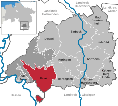
 | ||
| Coordinates: 51°39′35″N 9°38′09″E / 51.65972°N 9.63583°ECoordinates: 51°39′35″N 9°38′09″E / 51.65972°N 9.63583°E | ||
| Country | Germany | |
| State | Lower Saxony | |
| District | Northeim | |
| Government | ||
| • Mayor | Torsten Bauer (CDU) | |
| Area | ||
| • Total | 113.4 km2 (43.8 sq mi) | |
| Population (2015-12-31)[1] | ||
| • Total | 14,394 | |
| • Density | 130/km2 (330/sq mi) | |
| Time zone | CET/CEST (UTC+1/+2) | |
| Postal codes | 37170 | |
| Dialling codes | 05571, 05573, 05506, 05574 | |
| Vehicle registration | NOM | |
| Website | www.uslar.de | |

Uslar (Eastphalian: Üsseler) is a town and a municipality in southern Lower Saxony, Germany, in the south-western part of the district of Northeim, and in the south of the hills of Solling forest which are part of the Weser Uplands.
Uslar is located on the German Timber-Frame Road.
Geography
Uslar lies close to the borders of Hesse and North Rhine-Westphalia. Hanover is 110 kilometres (68 miles) to the north, Hesse's biggest city Frankfurt am Main is 240 kilometres (149 miles) to the south, and Berlin is 350 kilometres (217 miles) to northeast.
Division of the municipality
The municipality of Uslar consists of 19 towns and villages: Ahlbershausen, Allershausen, Bollensen, Delliehausen, Dinkelhausen, Eschershausen, Fürstenhagen, Gierswalde, Kammerborn, Offensen, Schlarpe, Schönhagen, Schöningen, Sohlingen, Uslar, Vahle, Verliehausen, Volpriehausen and Wiensen.

Transport
Uslar can be reached by car via the Landstraße (state's route) L554 from Göttingen. Through Uslar passes the Bundesstraße (federal route) B241 out of direction of Beverungen to Northeim. The closest Autobahns are the A7 (from Ausfahrt (Exit) Nörten-Hardenberg) and A44 (Ausfahrt Warburg). The nearest international airports are Hanover (IATA-Code: HAJ; ICAO EDDV), Paderborn-Lippstadt (IATA-Code: PAD) and Kassel-Calden. 1NM western the city center is a gliding airfield by the local soaring association LSV Solling e. V.[2] Furthermore, Uslar can be reached by the Solling Railway via Northeim. From Göttingen, Uslar can be reached by bus route 210[3] direction Uslar, from Holzminden, bus route 510.[4]
History
Uslar was first mentioned in 1006/1007. In the second half of the 12th century, the Welfen-dynasty started to rule Uslar until the 19th century. In 1599, the castle of Freudenthal was built, which burned down in 1612. In 1819 big parts of the town of Uslar burned down.
Economy and business
Uslar's industry uses the area's natural resources of wood, sand and water. In the 20th century, Uslar's furniture industry (Ilse-Möbel company, approx. 2000 employees in the 1950s) was world-famous. Nowadays, only tourism plays an important role in the area of Uslar (Uslarer Land). There is also the Privatbrauerei Haffner, which brews the Bergbräu family of beers, bottled in pop-top bottles much like Schleswig-Holstein's Flensburger beer and Holland's Grolsch.
The municipality Uslar is highly indebted. For example, the local swimming pool had to close in May 2011 and could only be re-opened in November 2012, with the help of a local initiative.[5] Since 2005 the population has been steadily decreasing, averaging at 168 people per year.[6]
International relations
Uslar's sister cities are:[7]
References
- ↑ Landesbetrieb für Statistik und Kommunikationstechnologie Niedersachsen, 102 Bevölkerung - Basis Zensus 2011, Stand 31. Dezember 2015 (Tabelle K1020014)
- ↑ Airfield data on LSV Solling e. V. homepage
- ↑ 210 route plan by the regional transport authority, (*.pdf, 32K)
- ↑ 510 route plan by the local transport authority, (*.pdf, 26KB)
- ↑ http://www.hna.de/lokales/uslar-solling/badespass-badeland-buergergenossenschaft-eroeffnet-hallenbad-2637814.html
- ↑ http://www.uslar.de/pics/medien/1_1387363919/Haushalt_THH.pdf
- ↑ http://www.uslar.de/staticsite/staticsite.php?menuid=69&topmenu=64
External links
| Wikimedia Commons has media related to Uslar. |
Towns and municipalities in Northeim (district) | ||
|---|---|---|