Urbandale, Iowa
| Urbandale, Iowa | |
|---|---|
| City | |
|
Urbandale welcome sign | |
 Location of Urbandale, Iowa | |
 Urbandale, Iowa Location in the United States | |
| Coordinates: 41°38′11″N 93°44′10″W / 41.63639°N 93.73611°WCoordinates: 41°38′11″N 93°44′10″W / 41.63639°N 93.73611°W | |
| Country |
|
| State |
|
| Counties | Polk, Dallas |
| Incorporated | April 16, 1917 |
| Government | |
| • Type | Council-manager government |
| • Mayor | Robert Andeweg |
| • City Manager | A.J. Johnson |
| Area[1] | |
| • Total | 21.94 sq mi (56.82 km2) |
| • Land | 21.92 sq mi (56.77 km2) |
| • Water | 0.02 sq mi (0.05 km2) |
| Elevation | 945 ft (288 m) |
| Population (2010)[2] | |
| • Total | 39,463 |
| • Estimate (2012[3]) | 41,020 |
| • Rank | 12th in Iowa |
| • Density | 1,800.3/sq mi (695.1/km2) |
| Time zone | Central (CST) (UTC-6) |
| • Summer (DST) | CDT (UTC-5) |
| ZIP codes | 50322, 50323, 50391 |
| Area code(s) | 515 |
| FIPS code | 19-79950 |
| GNIS feature ID | 0462504 |
| Website | http://www.urbandale.org |

Urbandale is a city in Polk and Dallas counties in the U.S. state of Iowa. As of the 2010 census, the city population was 39,463. It is part of the Des Moines–West Des Moines Metropolitan Statistical Area.
History
Urbandale was incorporated as a city on April 16, 1917. In its early days, Urbandale served as a streetcar suburb of Des Moines with four coal mines. Urbandale served as the end of the "Urbandale Line" after plans to build a railroad from Des Moines to Woodward were abandoned because of right-of-way issues. The coal mines had closed by the end of the 1940s while streetcar service ended in 1951.
In 1920, shortly after the city incorporated, Urbandale had 298 people. Its population in 1950 was 1,777, but the city grew rapidly after that along with the rest of Des Moines' suburbs. By 1970 Urbandale had 14,434 people, and in 2000 it had 29,072.[4] Although most of the city's developed area is in Polk County, Urbandale has expanded westward into Dallas County in recent years.
Geography
According to the United States Census Bureau, the city has a total area of 21.94 square miles (56.82 km2), of which, 21.92 square miles (56.77 km2) is land and 0.02 square miles (0.05 km2) is water.[1]
Demographics
| Historical populations | ||
|---|---|---|
| Year | Pop. | ±% |
| 1920 | 298 | — |
| 1930 | 596 | +100.0% |
| 1940 | 1,083 | +81.7% |
| 1950 | 1,777 | +64.1% |
| 1960 | 5,821 | +227.6% |
| 1970 | 14,434 | +148.0% |
| 1980 | 17,869 | +23.8% |
| 1990 | 23,500 | +31.5% |
| 2000 | 29,072 | +23.7% |
| 2010 | 39,463 | +35.7% |
| 2014 | 43,150 | +9.3% |
| 2015 | 44,062 | +2.1% |
| Source:"American FactFinder". United States Census Bureau. and Iowa Data Center Source: | ||
The median income for a household in the city was $59,744, and the median income for a family was $70,548 (these figures had risen to $69,269 and $86,885 respectively as of a 2007 estimate[6]). Males had a median income of $45,470 versus $32,631 for females. The per capita income for the city was $29,021. About 2.5% of families and 3.7% of the population were below the poverty line, including 4.7% of those under age 18 and 4.3% of those age 65 or over.
2010 census
As of the census[2] of 2010, there were 39,463 people, 15,596 households, and 10,815 families residing in the city. The population density was 1,800.3 inhabitants per square mile (695.1/km2). There were 16,319 housing units at an average density of 744.5 per square mile (287.5/km2). The racial makeup of the city was 91.1% White, 2.8% African American, 0.1% Native American, 3.5% Asian, 0.8% from other races, and 1.7% from two or more races. Hispanic or Latino of any race were 3.1% of the population.
There were 15,596 households of which 35.4% had children under the age of 18 living with them, 59.2% were married couples living together, 7.2% had a female householder with no husband present, 2.9% had a male householder with no wife present, and 30.7% were non-families. 25.0% of all households were made up of individuals and 8.8% had someone living alone who was 65 years of age or older. The average household size was 2.52 and the average family size was 3.04.
The median age in the city was 37.8 years. 26.1% of residents were under the age of 18; 6.2% were between the ages of 18 and 24; 28.9% were from 25 to 44; 27% were from 45 to 64; and 11.8% were 65 years of age or older. The gender makeup of the city was 48.4% male and 51.6% female.
2000 census
As of the census[7] of 2000, there were 29,072 people, 11,484 households, and 8,038 families residing in the city. The population density was 1,404.9 people per square mile (542.5/km²). There were 11,869 housing units at an average density of 573.6 per square mile (221.5/km²). The racial makeup of the city was 95.18% White, 1.53% African American, 0.09% Native American, 1.73% Asian, 0.10% Pacific Islander, 0.51% from other races, and 0.86% from two or more races. Hispanic or Latino of any race were 1.60% of the population.
There were 11,484 households out of which 35.0% had children under the age of 18 living with them, 60.7% were married couples living together, 7.1% had a female householder with no husband present, and 30.0% were non-families. 24.2% of all households were made up of individuals and 7.2% had someone living alone who was 65 years of age or older. The average household size was 2.51 and the average family size was 3.02.
Age spread: 26.3% under the age of 18, 7.0% from 18 to 24, 31.3% from 25 to 44, 24.6% from 45 to 64, and 10.8% who were 65 years of age or older. The median age was 37 years. For every 100 females there were 93.4 males. For every 100 females age 18 and over, there were 89.0 males.
Economy
(NRCS_Photo_Gallery).jpg)
While Urbandale is primarily a residential city, other development has increased in recent years, particularly in industrial parks along I-35/I-80.
The Multi-State Lottery Association (MUSL), which oversees operations for its multi-state games is located in Urbandale, although Powerball is now drawn in Florida.
In July 2005, Money magazine ranked Urbandale 53rd on its list of the "100 Best Places to Live" in the United States. The July 2006 Money Magazine list dropped the city from the list. Urbandale reappeared on the list in the July 2007 issue of Money Magazine as the 39th best place to live.[8]
A September 2008 Business Week magazine survey ranked Urbandale 12th among the nation’s top 20 communities likely to face trouble ahead from the still-brewing Wall Street financial crises. This was due to the large number of mortgage and banking based facilities in the city.[9]
Top employers
According to Urbandale's 2011 Comprehensive Annual Financial Report,[10] the top employers in the city are:
| # | Employer | # of Employees |
|---|---|---|
| 1 | Marsh & McLennan Companies | 1,100 |
| 2 | Citigroup | 600 |
| 3 | Wells Fargo Financial | 530 |
| 4 | United States Postal Service | 500 |
| 5 | Urbandale Community Schools | 450 |
| 6 | Iowa Health Home Care | 400 |
| 7 | MidAmerican Energy Company | 350 |
| 8 | Continental Western Group | 340 |
| 9 | Allied Insurance | 300 |
| 10 | Compressor Controls Corporation | 300 |
Parks and recreation
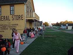
as seen during the 2007 Halloween event
Urbandale features 850 acres (3.4 km2) of parks and 33 miles (53 km) of recreational trails that connect to other trails in the Des Moines area.[11]
Urbandale is the home of Living History Farms, where Pope John Paul II spoke to a crowd estimated at 350,000 on October 4, 1979 and the Buccaneer Arena, home to the Des Moines Buccaneers hockey team.

Government
Urbandale uses the council-manager form of government. The city council consists of the mayor and five council members, all of which are elected to four-year terms.
Education
The Urbandale Community School District[12] consists of six elementary schools, one middle school, and one high school (Urbandale High School). Portions of Urbandale are also in the Dallas Center-Grimes, Des Moines, Johnston, Waukee, and West Des Moines school districts.
Notable people
- Eddie Berlin, former NFL Wide Receiver
- Scott Clemmensen, former NHL Goaltender
- Paul Gray, former bassist for the metal band Slipknot
- Scott Michael Greene, suspect in the 2016 shootings of Des Moines police officers
- Sean Runyan, former Major League Baseball player
References
- 1 2 "US Gazetteer files 2010". United States Census Bureau. Retrieved 2012-05-11.
- 1 2 "American FactFinder". United States Census Bureau. Retrieved 2012-05-11.
- ↑ "Population Estimates". United States Census Bureau. Retrieved 2013-05-23.
- ↑ City of Urbandale. "Urbandale History". Archived from the original on 2005-12-23. Retrieved 2006-05-14.
- ↑ "Census of Population and Housing". Census.gov. Retrieved June 4, 2015.
- ↑ "American FactFinder - Community Facts". Factfinder.census.gov. 2010-10-05. Retrieved 2016-11-03.
- ↑ "American FactFinder". United States Census Bureau. Retrieved 2008-01-31.
- ↑ "Best Places to Live". Money. Retrieved 2006-05-14.
- ↑
- ↑ "City of Urbandale CAFR" (PDF). Urbandale.org. Retrieved 2016-11-03.
- ↑ City of Urbandale. "Parks & Facilities". Archived from the original on 2006-05-13. Retrieved 2006-05-14.
- ↑ "Urbandale Community School District". Urbandale Community School District. 2009. Retrieved 28 October 2009.
External links
| Wikimedia Commons has media related to Urbandale, Iowa. |
- Official City Website
- Chamber of Commerce
- Urbandale Community School District
- City-Data Comprehensive Statistical Data and more about Urbandale
Municipalities and communities of Dallas County, Iowa, United States | ||
|---|---|---|
| Cities | ||
| Townships | ||
| Unincorporated communities | ||
| Footnotes | ‡This populated place also has portions in an adjacent county or counties | |
Municipalities and communities of Polk County, Iowa, United States | ||
|---|---|---|
| Cities | ||
| Townships | ||
| CDP | ||
| Other communities | ||
| Footnotes | ‡This populated place also has portions in an adjacent county or counties | |