Uppermill
| Uppermill | |
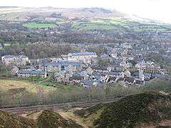 A view over Uppermill |
|
 Uppermill |
|
| OS grid reference | SD938090 |
|---|---|
| – London | 161 miles (261 km) SSE |
| Civil parish | Saddleworth |
| Metropolitan borough | Oldham |
| Metropolitan county | Greater Manchester |
| Region | North West |
| Country | England |
| Sovereign state | United Kingdom |
| Post town | OLDHAM |
| Postcode district | OL3 |
| Dialling code | 01457 |
| Police | Greater Manchester |
| Fire | Greater Manchester |
| Ambulance | North West |
| EU Parliament | North West England |
| UK Parliament | Oldham East and Saddleworth |
|
|
Coordinates: 53°32′56″N 2°00′14″W / 53.549°N 2.004°W
Uppermill is a village in Saddleworth—a civil parish of the Metropolitan Borough of Oldham, in Greater Manchester, England. Historically in the West Riding of Yorkshire, it lies on the River Tame in a valley amongst the South Pennines, 4.5 miles (7.2 km) east of Oldham, and 11 miles (17.7 km) east-northeast of Manchester. Uppermill forms a continuous urban area with the neighbouring village of Dobcross—the two have a combined population of 7,500.[1]
History
Although there is evidence of Roman activity in the area,[2] the history of Uppermill is dominated by the expansion of wool and cotton spinning into the area during the Industrial Revolution, with the construction of several mills.
Demography
| Dobcross/Uppermill compared | |||
|---|---|---|---|
| 2001 UK census | Dobcross/Uppermill[1] | Oldham (borough)[3] | England |
| Total population | 7,475 | 217,273 | 49,138,831 |
| White | 98.3% | 86.1 | 91% |
| Asian | 0.6% | 11.9 | 4.6% |
| Black | 0.2% | 0.6 | 2.3% |
The villages of Uppermill and Dobcross were treated as a single entity by the Office for National Statistics in the 2001 United Kingdom Census. As such, there are no demographic statistics for the village on its own. The statistics given here are for the combined population of Uppermill and Dobcross, which are about half a mile apart.
At the 2001 census, the area had a population of 7,475. Its population density was 10,324 inhabitants per square mile (3,986/km2), with a 100 to 92.6 female-to-male ratio.[4] Of those over 16 years old, 22.5% were single (never married), 49.6% married, and 7.8% divorced.[5] The 3,225 households in the area included 27.7% one-person, 43.2% married couples living together, 8.1% were co-habiting couples, and 6.9% single parents with their children.[6] Of those aged 16–74, 21.1% had no academic qualifications, significantly below the averages of Oldham (37.7%) and England (28.9%).[7][8]
At the 2001 UK census, 79.6% of residents in the area reported themselves as being Christian, 0.3% Muslim, 0.3% Hindu, 0.2% Buddhist and 0.2% Jewish. The census recorded 13.3% as having no religion, 0.2% had an alternative religion and 6.0% did not state their religion.[9]
Geography
 |
Delph, Denshaw | Dobcross | Diggle, Marsden | |
| Scouthead, Oldham | |
Saddleworth Moor, Holmfirth | ||
| ||||
| | ||||
| Grasscroft, Mossley | Greenfield | Chew Valley |
References
- 1 2 "Census 2001 Key Statistics - Urban area results by population size of urban area". ons.gov.uk. Office for National Statistics. 22 July 2004. KS06 Ethnic group
 . Retrieved 22 April 2009.
 - ↑ "Bronze Age dagger retrieved near proposed windfarm". Stonepages.com. 14 February 2004. Retrieved 17 April 2008.
- ↑ "Oldham Metropolitan Borough ethnic group". Statistics.gov.uk. Retrieved 22 April 2009.
- ↑ "Census 2001 Key Statistics - Urban area results by population size of urban area". ons.gov.uk. Office for National Statistics. 22 July 2004. KS01 Usual resident population . Retrieved 22 April 2009.
- ↑ "Census 2001 Key Statistics - Urban area results by population size of urban area". ons.gov.uk. Office for National Statistics. 22 July 2004. KS04 Marital status . Retrieved 22 April 2009.
- ↑ "Census 2001 Key Statistics - Urban area results by population size of urban area". ons.gov.uk. Office for National Statistics. 22 July 2004. KS20 Household composition . Retrieved 22 April 2009.
- ↑ "Oldham Metropolitan Borough key statistics". Statistics.gov.uk. Retrieved 22 April 2009.
- ↑ "Census 2001 Key Statistics - Urban area results by population size of urban area". ons.gov.uk. Office for National Statistics. 22 July 2004. KS13 Qualifications and students . Retrieved 22 April 2009.
- ↑ "Census 2001 Key Statistics - Urban area results by population size of urban area". ons.gov.uk. Office for National Statistics. 22 July 2004. KS07 Religion . Retrieved 22 April 2009.
External links
| Wikimedia Commons has media related to Uppermill. |