Upminster Bridge tube station
| Upminster Bridge | |
|---|---|
|
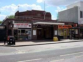
Entrance on Upminster Road | |
 Upminster Bridge Location of Upminster Bridge in Greater London | |
| Location | Upminster Bridge |
| Local authority | London Borough of Havering |
| Managed by | London Underground |
| Number of platforms | 2 |
| Fare zone | 6 |
| London Underground annual entry and exit | |
| 2012 |
|
| 2013 |
|
| 2014 |
|
| 2015 |
|
| Railway companies | |
| Original company | London, Midland and Scottish Railway |
| Key dates | |
| 1934 | Opened |
| 1948 | Ownership transferred to British Railways |
| 1969 | Ownership transferred to London Transport |
| Other information | |
| Lists of stations | |
| WGS84 | 51°33′29″N 0°14′03″E / 51.558°N 0.2341°ECoordinates: 51°33′29″N 0°14′03″E / 51.558°N 0.2341°E |
|
| |
Upminster Bridge is a London Underground station on Upminster Road in the Upminster Bridge neighbourhood of the London Borough of Havering in northeast London, England. The station is on the District line and is the penultimate station on the eastern extremity of that line. The station was opened on 17 December 1934 by the London, Midland and Scottish Railway on the local electrified tracks between Upminster and Barking that were constructed in 1932. The main station building is of a distinctive polygonal design.[2] It has relatively low usage for a suburban station with approximately 1 million entries and exits during 2011.[3]
History
The London, Tilbury and Southend Railway from Fenchurch Street and Barking was constructed through the Upminster Bridge area in 1885, with stations at Hornchurch and Upminster.[4] The Whitechapel and Bow Railway opened in 1902 and allowed through services of the District Railway to operate to Upminster. The Metropolitan District converted to electric trains in 1905 and services were cut back to East Ham. Delayed by World War I,[4] electrified tracks were extended by the London, Midland and Scottish Railway to Upminster and through services resumed in 1932.[5][6] The District Railway was incorporated into London Transport in 1933, and became known as the District line.
The new tracks built by the London, Midland and Scottish Railway allowed additional intermediate stations to be constructed on the local lines between 1932 and 1935. Increased local demand was caused by the expansion of the built up area of suburban London during the interwar period. The station at Upminster Bridge opened with platforms on the local electric lines on 17 December 1934.[5] The station was operated by the London, Midland and Scottish Railway but was only served by District line trains. After nationalisation of the railways in 1948 management of the station passed to British Railways and in 1969 ownership transferred to the London Underground.[7]
Design

The station consists of a central island platform between the tracks that are elevated on a railway embankment. There are four tracks through the site although there are no platforms for the c2c lines. The full length of the platform is covered by a single station canopy with a central waiting room. The Art Deco red brick ticket office is located below platform level to which it is connected by a subway and stairway. Although similar to the other single-storey station buildings on this part of the route, it is notable for its high atrium roof and polygonal shape.[2] The floor is tiled with a reversed swastika pattern, a popular decorative design at the time the station was constructed.[8] The station is listed as a building of local heritage interest by Havering London Borough Council.[9]
As part of the public–private partnership arrangement for maintenance of the London Underground, the station was refurbished by Metronet during 2005 and 2006. Works included provision of tactile strips and colour contrasted handrails for the visually impaired, installation of closed-circuit television cameras, passenger help points, new electronic departure information displays on the platforms, a new public address system, and improved lighting.[10] The station does not have step free access from the platforms to the street.[11]
Location

The station is named after a nearby crossing of the River Ingrebourne.[12] The river was the boundary between the ancient parishes of Hornchurch and Upminster and the station is located on the western Hornchurch side.[13] The station is situated on Upminster Road in the London Borough of Havering and is flanked by a parade of shops. It is situated in a primarily residential area and is near to Havering Sixth Form College and Hornchurch Stadium.[14][15] London bus routes 248, 370 and Ensignbus route 26 serve the site of the station, providing connections to Hornchurch, Lakeside, Romford and Upminster.[16] The London Loop key walking route passes outside the station, and it forms the end point of section 22 from Harold Wood and the starting point of section 23 to Rainham.[17][18] The station is located on the eastern extremity of the District line and is the penultimate station before the terminus at Upminster.[19] Upminster station is 1.24 kilometres (0.77 mi) to the east of the station and Hornchurch is 1.26 kilometres (0.78 mi) to the west.[20]
Services
|
| |
|
|
The station is in London fare zone 6. The typical off-peak service from the station is twelve District line trains per hour to Upminster and twelve to Earl's Court, of which six continue to Ealing Broadway and six continue to Richmond. At peak periods the number of trains per hour increases to fifteen[21] and some trains continue from Earl's Court to Wimbledon. Services towards central London operate from approximately 05:00 to 23:30 and services to Upminster operate from approximately 06:00 to 01:30.[22] The journey time to Upminster is two minutes; to Barking is approximately 20 minutes, and to Tower Hill is approximately 42 minutes.[22] Since 2006, the station has been one of the first on the network to operate without a staffed ticket office.[23] Total number of passenger entries and exits at the station during the year is as follows:[3]
| Year | Thousands of entries and exits (% change from prior year) |
|---|---|
| 2003 | 750 |
| 2004 | 870(+13.79%) |
| 2005 | 856(-1.64%) |
| 2006 | 822(-4.14%) |
| 2007 | 781(-5.25%) |
| 2008 | 930(+16.02%) |
| 2009 | 865(+6.06%) |
| 2010 | 890(+2.81%) |
| 2011 | 990(+10.10%) |
During 2011 there were 990,000 passenger entries and exits at the station, continuing a trend of growth over the preceding eight years, but lower than neighbouring stations on the route.[3]
References
- 1 2 3 4 "Multi-year station entry-and-exit figures" (XLS). London Underground station passenger usage data. Transport for London. April 2016. Retrieved 3 May 2016.
- 1 2 Menear, Laurence (1985). London's Underground Stations: A Social and Architectural Study. Baton Transport. p. 89. ISBN 0-85936-124-1.
- 1 2 3 "Upminster Bridge - Annual entry and exit frequencies 2011". Transport for London. Retrieved 14 January 2013.
- 1 2 "London, Tilbury and Southend Railway" (PDF), Local Studies Information Sheets, Barking and Dagenham London Borough Council, 2008, retrieved 8 February 2010
- 1 2 Rose, Douglas (1999). The London Underground: A diagrammatic history (7 ed.). Douglas Rose. ISBN 1-85414-219-4.
- ↑ Wolmar, Christian (2005). The Subterranean Railway: How the London Underground Was Built and How It Changed the City Forever. Atlantic Books. p. 268. ISBN 1-84354-023-1.
- ↑ "Some basic UK rail statistics - Notes". Fifth Dimension Associates. 2009. Retrieved 8 February 2010.
- ↑ "Upminster Bridge Underground station, District line". Photographic collection. London Transport Museum. 1935. Retrieved 8 February 2010.
- ↑ "Heritage Supplementary Planning Document" (PDF). Havering London Borough Council. 2011. Retrieved 24 November 2011.
- ↑ "Transforming the Tube" (PDF). Transport for London. November 2009. Retrieved 8 February 2010.
- ↑ "Step Free Tube Map Guide" (PDF). Transport for London. December 2009. Retrieved 8 February 2010.
- ↑ Mills, A.D. (2001). Dictionary of London Place Names. Oxford University Press. ISBN 0-19-280106-6.
- ↑ Powell, W.R. (Edr.) (1978). Upminster: Introduction and manors, A History of the County of Essex: Volume 7. Victoria County History. British History Online. Retrieved 8 February 2010.
- ↑ "How to get to Havering Sixth Form College". Havering Sixth Form College. Retrieved 8 February 2010.
- ↑ Grose, Tim (1 October 2004). "Hornchurch Stadium". UK Running Track Directory. Retrieved 8 February 2010.
- ↑ "Buses from Upminster Bridge" (PDF). Transport for London. April 2007. Retrieved 8 February 2010.
- ↑ "Section 22 Harold Wood to Upminster Bridge". London Loop. Transport for London. Retrieved 8 February 2010. External link in
|work=(help) - ↑ "Section 23 Upminster Bridge to Rainham". London Loop. Transport for London. Retrieved 8 February 2010. External link in
|work=(help) - ↑ "Tube Map" (PDF). Transport for London. December 2009. Retrieved 8 February 2010.
- ↑ Baker, Charles (2006). "Inter Station Database". Transport for London. Retrieved 8 February 2010.
- ↑ "Circle, Hammersmith and City, District and Metropolitan lines: Proposed Service Changes" (PDF). Transport for London. February 2009. Retrieved 8 February 2010.
- 1 2 "District line" (PDF). First and Last Trains. Transport for London. 20 February 2012. Retrieved 24 November 2012.
- ↑ "New ticket office opening hours from February 5". Transport for London. 3 February 2006. Retrieved 24 November 2012.
External links
| Wikimedia Commons has media related to Upminster Bridge tube station. |
- Images in the collection of London Transport Museum
- London Underground - Departure boards - District line: Upminster Bridge station
| Preceding station | Following station | |||
|---|---|---|---|---|
| District line | Terminus |
| Companies and organisations |
| ||||||||||||||||||
|---|---|---|---|---|---|---|---|---|---|---|---|---|---|---|---|---|---|---|---|
| Airports |
| ||||||||||||||||||
| Major stations |
| ||||||||||||||||||
| Roads |
| ||||||||||||||||||
| Ticketing | |||||||||||||||||||
| Other | |||||||||||||||||||
| Former BR sectors | |||||||||||||||||||
| |||||||||||||||||||