University of Connecticut Historic District
|
University of Connecticut Historic District-Connecticut Agricultural School | |
|
The Wilbur Cross Library | |
  | |
| Location |
Roughly CT 195/Storrs Rd. at Eagleville Rd., Mansfield, Connecticut |
|---|---|
| Coordinates | 41°48′29″N 72°15′3″W / 41.80806°N 72.25083°WCoordinates: 41°48′29″N 72°15′3″W / 41.80806°N 72.25083°W |
| Area | 105 acres (42 ha) |
| Architect | Charles N. Lowrie |
| Architectural style | Late 19th and 20th Century Revivals; Federal; Collegiate Gothic |
| NRHP Reference # | 88003202[1] |
| Added to NRHP | January 31, 1989 |
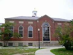
The University of Connecticut Historic District is a 105-acre (42 ha) historic district including the historic campus of the Connecticut Agricultural School, now the University of Connecticut. It is located Storrs in the town of Mansfield, Connecticut, flanking Storrs Road (Connecticut Route 195). The principal elements of the district are 23 masonry buildings erected between 1906 and 1942, in Collegiate Gothic, Colonial Revival, and Classical Revival styles. There are also 18 residential structures, some dating to the 18th century, and including the President's House, built in 1940. These are located in an area historically known as Faculty Row, which is now part of Whitney and Gilbert Roads. The master plan for the campus was drafted in the early 20th century by Charles N. Lowrie, a landscape architect, and was followed to a substantial degree by subsequent development. The only non-university buildings in the district are those associated with the Storrs Community Church.[2]
The district was listed on the National Register of Historic Places in 1989.[1]
See also
References
- 1 2 National Park Service (2009-03-13). "National Register Information System". National Register of Historic Places. National Park Service.
- ↑ Jan Cunningham (May 7, 1988). "NRHP Inventory-Nomination: Connecticut Agricultural School / University of Connecticut Historic District" (PDF). National Park Service. and Accompanying 19 photos from 1988 (see photo captions page 25 of text document)
| Topics | |
|---|---|
| Lists by states |
|
| Lists by insular areas | |
| Lists by associated states | |
| Other areas | |
| |