Union Township, Licking County, Ohio
| Union Township, Licking County, Ohio | |
|---|---|
| Township | |
|
Autumn colors on Mill Dam Road | |
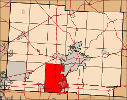 Location in Licking County | |
| Coordinates: 39°57′45″N 82°30′13″W / 39.96250°N 82.50361°WCoordinates: 39°57′45″N 82°30′13″W / 39.96250°N 82.50361°W | |
| Country | United States |
| State | Ohio |
| County | Licking |
| Area | |
| • Total | 42.7 sq mi (110.7 km2) |
| • Land | 42.2 sq mi (109.3 km2) |
| • Water | 0.5 sq mi (1.4 km2) |
| Elevation[1] | 899 ft (274 m) |
| Population (2000) | |
| • Total | 8,339 |
| • Density | 197.6/sq mi (76.3/km2) |
| Time zone | Eastern (EST) (UTC-5) |
| • Summer (DST) | EDT (UTC-4) |
| FIPS code | 39-78400[2] |
| GNIS feature ID | 1086479[1] |

Union Township is one of the twenty-five townships of Licking County, Ohio, United States. The 2000 census found 8,339 people in the township, 3,259 of whom lived in the unincorporated portions of the township.[3]
Geography
Located on the southern edge of the county, it borders the following townships and city:
- Granville Township - north
- Newark - northeast
- Licking Township - east
- Thorn Township, Perry County - southeast
- Buckeye Lake - southeast[4]
- Walnut Township, Fairfield County - south
- Liberty Township, Fairfield County - southwest corner
- Harrison Township - west
- St. Albans Township - northwest corner
Several municipalities are located in Union Township:
- Part of the village of Buckeye Lake, in the southeast
- Part of the city of Heath, in the northeast
- The village of Hebron, in the east
Name and history
It is one of twenty-seven Union Townships statewide.[5]
Government
The township is governed by a three-member board of trustees, who are elected in November of odd-numbered years to a four-year term beginning on the following January 1. Two are elected in the year after the presidential election and one is elected in the year before it. There is also an elected township fiscal officer,[6] who serves a four-year term beginning on April 1 of the year after the election, which is held in November of the year before the presidential election. Vacancies in the fiscal officership or on the board of trustees are filled by the remaining trustees.
References
- 1 2 "US Board on Geographic Names". United States Geological Survey. 2007-10-25. Retrieved 2008-01-31.
- ↑ "American FactFinder". United States Census Bureau. Archived from the original on September 11, 2013. Retrieved 2008-01-31.
- ↑ Licking County, Ohio — Population by Places Estimates Ohio State University, 2007. Accessed 15 May 2007.
- ↑ Williams, Joe (August 28, 2013). "New 'paper' township limits fire levy voting". The Advocate. Newark, Ohio: Gannett Company. Retrieved September 16, 2013.
That vote creates a new township that matches the boundaries of Buckeye Lake village and makes village residents who once were residents of Union Township now part of Buckeye Lake Township.
- ↑ "Detailed map of Ohio" (PDF). United States Census Bureau. 2000. Retrieved 2007-02-16.
- ↑ §503.24, §505.01, and §507.01 of the Ohio Revised Code. Accessed 4/30/2009.
External links
Municipalities and communities of Licking County, Ohio, United States | ||
|---|---|---|
| Cities | 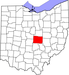 | |
| Villages | ||
| Townships | ||
| CDPs | ||
| Unincorporated communities | ||
| Ghost towns | ||
| Footnotes | ‡This populated place also has portions in an adjacent county or counties | |