Union County, Arkansas
| Union County, Arkansas | |
|---|---|
|
Union County Courthouse in El Dorado | |
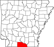 Location in the U.S. state of Arkansas | |
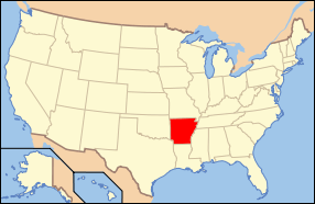 Arkansas's location in the U.S. | |
| Founded | November 2, 1829 |
| Seat | El Dorado |
| Largest city | El Dorado |
| Area | |
| • Total | 1,055 sq mi (2,732 km2) |
| • Land | 1,039 sq mi (2,691 km2) |
| • Water | 16 sq mi (41 km2), 1.5% |
| Population (est.) | |
| • (2015) | 40,144 |
| • Density | 40/sq mi (15/km²) |
| Congressional district | 4th |
| Time zone | Central: UTC-6/-5 |
| Website |
www |


Union County is a county located in the U.S. state of Arkansas. As of the 2010 census, the population was 41,639.[1] The county seat is El Dorado. The county was formed on November 2, 1829, and named in recognition of the citizens' petition for a new county, stating that they were petitioning "in the spirit of Union and Unity." The county is directly adjacent to Union Parish in the state of Louisiana.
The El Dorado, AR Micropolitan Statistical Area includes all of Union County.
Called once by boosters the “Queen City of South Arkansas” and, more recently, “Arkansas’s Original Boomtown,” the city was the heart of the 1920s oil boom in South Arkansas.[2]
History
Union County was formed on November 2, 1828, from portions of Clark and Hempstead counties.
Geography
According to the U.S. Census Bureau, the county has a total area of 1,055 square miles (2,730 km2), of which 1,039 square miles (2,690 km2) is land and 16 square miles (41 km2) (1.5%) is water.[3] It is the largest county by area in Arkansas. Union County, along with Columbia County, has the largest bromine reserve in the United States. The lowest point in the state of Arkansas is located on the Ouachita River in Union County and Ashley County, where it flows out of Arkansas and into Louisiana.
Adjacent counties
- Ouachita County (northwest)
- Calhoun County (north)
- Bradley County (northeast)
- Ashley County (east)
- Morehouse Parish, Louisiana (southeast)
- Union Parish, Louisiana (south)
- Claiborne Parish, Louisiana (southwest)
- Columbia County (west)
Union County in Arkansas and Union Parish in Louisiana are two of twenty-two counties or parishes in the United States with the same name to border each other across state lines. The others are Big Horn County, Montana and Big Horn County, Wyoming, Sabine County, Texas and Sabine Parish, Louisiana, Bristol County, Massachusetts and Bristol County, Rhode Island, Kent County, Maryland and Kent County, Delaware, Escambia County, Alabama and Escambia County, Florida, Pike County, Illinois and Pike County, Missouri, Teton County, Idaho and Teton County, Wyoming, Park County, Montana and Park County, Wyoming, San Juan County, New Mexico and San Juan County, Utah, and Vermilion County, Illinois and Vermillion County, Indiana. respectively. (Note, despite the different spellings, the source of the name is the same for Vermilion County, Illinois and Vermillion County, Indiana—the Vermillion River which flows through both counties.)
National protected area
Demographics
| Historical population | |||
|---|---|---|---|
| Census | Pop. | %± | |
| 1830 | 640 | — | |
| 1840 | 2,889 | 351.4% | |
| 1850 | 10,298 | 256.5% | |
| 1860 | 12,288 | 19.3% | |
| 1870 | 10,571 | −14.0% | |
| 1880 | 13,419 | 26.9% | |
| 1890 | 14,977 | 11.6% | |
| 1900 | 22,495 | 50.2% | |
| 1910 | 30,723 | 36.6% | |
| 1920 | 29,691 | −3.4% | |
| 1930 | 55,800 | 87.9% | |
| 1940 | 50,461 | −9.6% | |
| 1950 | 49,686 | −1.5% | |
| 1960 | 49,518 | −0.3% | |
| 1970 | 45,428 | −8.3% | |
| 1980 | 48,573 | 6.9% | |
| 1990 | 46,719 | −3.8% | |
| 2000 | 45,629 | −2.3% | |
| 2010 | 41,639 | −8.7% | |
| Est. 2015 | 40,144 | [4] | −3.6% |
| U.S. Decennial Census[5] 1790–1960[6] 1900–1990[7] 1990–2000[8] 2010–2015[1] | |||

As of the 2000 United States Census,[10] there were 45,629 people, 17,989 households, and 12,646 families residing in the county. The population density was 44 people per square mile (17/km²). There were 20,676 housing units at an average density of 20 per square mile (8/km²). The racial makeup of the county was 66.15% White, 31.97% Black or African American, 0.24% Native American, 0.40% Asian, 0.01% Pacific Islander, 0.46% from other races, and 0.77% from two or more races. 1.14% of the population were Hispanic or Latino of any race.
There were 17,989 households out of which 32.20% had children under the age of 18 living with them, 51.30% were married couples living together, 15.20% had a female householder with no husband present, and 29.70% were non-families. 26.90% of all households were made up of individuals and 12.10% had someone living alone who was 65 years of age or older. The average household size was 2.48 and the average family size was 3.00.
In the county the population was spread out with 25.90% under the age of 18, 8.30% from 18 to 24, 27.00% from 25 to 44, 22.70% from 45 to 64, and 16.10% who were 65 years of age or older. The median age was 38 years. For every 100 females there were 91.60 males. For every 100 females age 18 and over, there were 86.00 males.
The median income for a household in the county was $29,809, and the median income for a family was $36,805. Males had a median income of $31,868 versus $19,740 for females. The per capita income for the county was $16,063. About 14.70% of families and 18.70% of the population were below the poverty line, including 25.80% of those under age 18 and 14.30% of those age 65 or over.
Union County/Union Parish monument
In 1931, a monument was established at the Union County border with Union Parish, Louisiana, through the private efforts of former Arkansas Governor George Washington Donaghey (1856–1937), who was born in Union Parish and grew up in the border area before he moved as a teenager to Conway, Arkansas. As governor, he oversaw the construction of the state capitol building in Little Rock and brought about the establishment of the state health unit and its agricultural colleges.
After his gubernatorial tenure, Donaghey, who felt a kinship to both states, commissioned a park on the land about the monument. Known for its intricate carvings and Art Deco style, the monument includes references to different modes of transportation a century apart—1831 and 1931—and mentions Huey P. Long, Jr., whose educational program Donaghey admired. The land was not registered with the state parks offices in either state, timber companies cut trees thereabouts, and the monument was forgotten. In 1975, State Representative Louise B. Johnson obtained passage of a law to refurbish the monument. Restoration efforts were finally unveiled in 2009.[11]
Transportation
Major highways
 U.S. Highway 63
 U.S. Highway 82
 U.S. Highway 167
 Highway 7
 Highway 15
 Highway 129
 Future Interstate 69
Airport
Communities
Cities
Towns
Unincorporated community
Townships

Townships in Arkansas are the divisions of a county. Each township includes unincorporated areas; some may have incorporated cities or towns within part of their boundaries. Arkansas townships have limited purposes in modern times. However, the United States Census does list Arkansas population based on townships (sometimes referred to as "county subdivisions" or "minor civil divisions"). Townships are also of value for historical purposes in terms of genealogical research. Each town or city is within one or more townships in an Arkansas county based on census maps and publications. The townships of Union County are listed below; listed in parentheses are the cities, towns, and/or census-designated places that are fully or partially inside the township. [12][13]
- Boone
- Cornie
- El Dorado (El Dorado)
- Franklin (Calion)
- Garner
- Harrison
- Henderson (Junction City)
- Jackson
- Johnson
- Lapile (Felsenthal, Huttig, Strong)
- Norphlet (Norphlet)
- Smackover (Smackover)
- Tubal
- Van Buren
- Wesson
- Wilmington
See also
References
- 1 2 "State & County QuickFacts". United States Census Bureau. Retrieved May 19, 2014.
- ↑ Bridges, Kenneth. "El Dorado (Union County)". Encyclopedia of Arkansas. Retrieved 2 June 2015.
- ↑ "2010 Census Gazetteer Files". United States Census Bureau. August 22, 2012. Retrieved August 27, 2015.
- ↑ "County Totals Dataset: Population, Population Change and Estimated Components of Population Change: April 1, 2010 to July 1, 2015". Retrieved July 2, 2016.
- ↑ "U.S. Decennial Census". United States Census Bureau. Retrieved August 27, 2015.
- ↑ "Historical Census Browser". University of Virginia Library. Retrieved August 27, 2015.
- ↑ Forstall, Richard L., ed. (March 27, 1995). "Population of Counties by Decennial Census: 1900 to 1990". United States Census Bureau. Retrieved August 27, 2015.
- ↑ "Census 2000 PHC-T-4. Ranking Tables for Counties: 1990 and 2000" (PDF). United States Census Bureau. April 2, 2001. Retrieved August 27, 2015.
- ↑ Based on 2000 census data
- ↑ "American FactFinder". United States Census Bureau. Retrieved 2011-05-14.
- ↑ "Matthew Hamil, "Monument Forgotten by Time"". Monroe News Star, August 31, 2009. Archived from the original on September 3, 2009. Retrieved August 31, 2009.
- ↑ 2011 Boundary and Annexation Survey (BAS): Union County, AR (PDF) (Map). U. S. Census Bureau. Retrieved 2011-08-07.
- ↑ "Arkansas: 2010 Census Block Maps - County Subdivision". United States Census Bureau. Retrieved May 29, 2014.
 |
Ouachita County | Calhoun County | Bradley County | |
| Columbia County | |
Ashley County | ||
| ||||
| | ||||
| Claiborne Parish, Louisiana | Union Parish, Louisiana | Morehouse Parish, Louisiana |
Municipalities and communities of Union County, Arkansas, United States | ||
|---|---|---|
| Cities | | |
| Town | ||
| Unincorporated communities | ||
Coordinates: 33°11′14″N 92°35′29″W / 33.18722°N 92.59139°W