Unguja North Region
"Kaskazini" redirects here. For other uses, see Kaskazini (disambiguation).
| Unguja North Region Mkoa wa Unguja Kaskazini (Swahili) | |
|---|---|
| Region | |
|
Matemwe beach | |
 Location in Tanzania | |
| Country | Tanzania |
| Zone | Zanzibar |
| Capital | Mkokotoni |
| Area | |
| • Total | 470 km2 (180 sq mi) |
| Population (2012) | |
| • Total | 187,455 |
| • Density | 400/km2 (1,000/sq mi) |
| Time zone | EAT (UTC+3) |
| Postcode | 73xxx |
| Area code(s) | 024 |
| Website |
zanzibar |

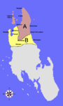
Unguja North Region is one of the 30 regions of Tanzania. Located on the island of Zanzibar, Mkokotoni serves as the region's capital. Zanzibar North is divided into two districts, Kaskazini A and Kaskazini B.[1]
Districts
Map
The region is administratively divided into two districts:
| Districts of Unguja North Region | ||
|---|---|---|
| District | Population (2012) | |
| Kaskazini A | 105,780 | |
| Kaskazini B | 81,675 | |
| Total | 187,455 | |
Kaskazini A
As of 2002, Kaskazini A had a population of 84,348.[2] As of 2007, it was divided into twenty-eight wards:[3]
|
|
|
Kaskazini B
As of 2002, Kaskazini B had a population of 84,348.[2] As of 2007, it was divided into twenty-three wards:[4]
|
|
|
Constituencies
As of 2010 election Zanzibar North Region had eight constituencies:[5][6]
| Kaskazini A Constituencies | | Kaskazini B Constituencies |
|---|---|---|
| Chaani Constituency | Bumbwini Constituency | |
| Matemwe Constituency | Donge Constituency | |
| Mkwajuni Constituency | Kitope Constituency | |
| Nungwi Constituency | ||
| Tumbatu Constituency |
References
- ↑ "Zanzibar North Region - Tanzania". Africa Development Information. 2007.
- 1 2 "2002 Tanzania National Census – North Unguja (North Zanzibar)". Archived from the original on 18 March 2004.
- ↑ "Kaskazini A District - Tanzania". Africa Development Information. 2007.
- ↑ "Kaskazini B District - Tanzania". Africa Development Information. 2007.
- ↑ "Organisations located in Zanzibar North Region - Tanzania". African Development Information.
- ↑ "2010 Parliamentary Election Results - As receveid by NEC". National Electoral Commission of Tanzania (NEC).
| Mainland | ||
|---|---|---|
| Zanzibar | ||
Coordinates: 5°55′00″S 39°20′00″E / 5.9167°S 39.3333°E
This article is issued from Wikipedia - version of the 9/5/2016. The text is available under the Creative Commons Attribution/Share Alike but additional terms may apply for the media files.