Uckermark (district)
- This article is about a district in Germany. For the historical region, see Uckermark. For information about the Nazi concentration camp with the same name, see Uckermark concentration camp.
| Uckermark | |
|---|---|
| District | |
 | |
| Country |
|
| State | Brandenburg |
| Capital | Prenzlau |
| Area | |
| • Total | 3,058.2 km2 (1,180.8 sq mi) |
| Population (31 December 2015)[1] | |
| • Total | 121,014 |
| • Density | 40/km2 (100/sq mi) |
| Time zone | CET (UTC+1) |
| • Summer (DST) | CEST (UTC+2) |
| Vehicle registration | UM |
| Website | http://www.uckermark.de |
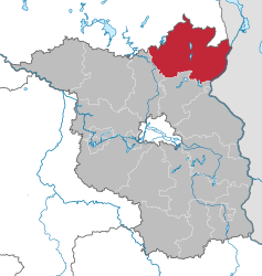
Uckermark is a Kreis (district) in the northeastern part of Brandenburg, Germany. Neighboring districts are (clockwise from the south) Barnim and Oberhavel, the districts Mecklenburgische Seenplatte and Vorpommern-Greifswald in Mecklenburg-Vorpommern, and to the east Poland (Police County and Gryfino County). It is the largest district of Germany areawise. The district is named after the historical region of Uckermark.
Geography
The Uckermark is named after the Uecker river, which is a tributary of the Oder. The Oder River, forming the Polish border, bounds the district in the east. The district is characterised by 600 lakes and 2,800 km of rivers. Rare animals still live in the lakeland, such as ospreys, beavers and otters.
The western parts of the Lower Oder Valley National Park are located in the district.
History
The Uckermark was originally divided between the administrative units Uckerkreis and Stolpirischer Kreis. In 1817 as part of the Province of Brandenburg, a third district was created in the area, the district Angermünde, and the other two districts were renamed to Prenzlau and Templin. The current district Uckermark was created in 1993 by merging the previous districts Angermünde, Prenzlau and Templin, as well as the previously district-free city Schwedt.
Demography
 Development of Population since 1875 within the Current Boundaries (Blue Line: Population; Dotted Line: Comparison to Population Development of Brandenburg state; Grey Background: Time of Nazi rule; Red Background: Time of Communist rule)
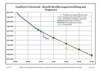 Recent Population Development (Blue Line) and Forecasts
|
|
|
|
Coat of arms
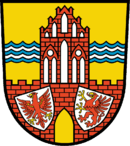 |
The main feature of the coat of arms are the brick buildings of the district — the churches of Prenzlau and Angermünde. The city wall below recalls the many wars of the Middle Ages. The two circular windows in the church tower symbolizes the division into two districts before the reform of 1817, the three Gothic windows represent this division. On the city wall are two shields — one with the griffin of Pomerania, the other with the red eagle of Brandenburg. The wavy lines in the upper part represent the main rivers in the district, Oder, Randow, and Uecker. The yellow color of the background represents the agriculture of the district, as the Uckermark was the "granary" of Brandenburg. The coat of arms was created by Hans Benthin, and was officially granted on November 8, 1995. |
Towns and municipalities
| Amt-free towns | Ämter | |
|---|---|---|
|
|
2. Gartz (Oder) 3. Gerswalde |
4. Gramzow 5. Oder-Welse |
| 1seat of the Amt; 2town | ||
References
- ↑ "Bevölkerung im Land Brandenburg nach amtsfreien Gemeinden, Ämtern und Gemeinden 31. Dezember 2015 (Fortgeschriebene amtliche Einwohnerzahlen auf Grundlage des Zensus 2011)". Amt für Statistik Berlin-Brandenburg (in German). 2016.
- ↑ Detailed data sources are to be found in the Wikimedia Commons.Population Projection Brandenburg at Wikimedia Commons
External links
| Wikimedia Commons has media related to Uckermark. |
- Official website (German)
- Touristical website (German)
- city-map and Internet Market Place (German)
- online-shop for specialities and arts and crafts (German)
| Urban districts | |
|---|---|
| Rural districts | |
Coordinates: 53°15′N 13°52′E / 53.250°N 13.867°E