Ubinas
| Ubinas | |
|---|---|
 Ubinas volcano and Salinas lagoon, seen here in August 2015. | |
| Highest point | |
| Elevation | 5,672 m (18,609 ft) [1] |
| Coordinates | 16°21′18″S 70°54′11″W / 16.35500°S 70.90306°WCoordinates: 16°21′18″S 70°54′11″W / 16.35500°S 70.90306°W [1] |
| Geography | |
 Ubinas Peru | |
| Location | Moquegua Region, Peru |
| Parent range | CVZ, Andes |
| Geology | |
| Mountain type | Stratovolcano |
| Last eruption | March to August 2015 (ongoing)[1] |
Ubinas is an active 5,672-metre (18,609 ft) stratovolcano in the Andes of southern Peru. Until 2006, this stratovolcano had not erupted for about 40 years.
Description
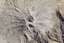
Ubinas is located in southern Peru. The upper slopes of the volcano, composed primarily of Pleistocene andesitic lava flows, steepen to nearly 45 degrees. The steep-walled, 1.4 km (4,600 ft) wide and 150 m (490 ft) deep summit caldera contains an ash cone with a 500 m (1,600 ft)-wide funnel-shaped vent that is 200 m (660 ft) deep. Debris-avalanche deposits from the collapse of the SE flank of Ubinas extend 10 km (6.2 mi) from the volcano.
The volcano is a composite cone built on a high plateau formed from Oligocene-Miocene (Neogene) ignimbrites and intrusive rocks. Ubinas comprises two edifices that divide two major periods of its eruptive behaviour. The first is the lower volcano under 600 m (2,000 ft) high, known as Ubinas 1 (eruptive period >376 ka), which collapsed and formed a debris-avalanche deposit as far as 12 km (7.5 mi) downstream Rio Ubinas. This collapse was followed by an eruption of non-welded ignimbrites, ponding to a thickness of 150 m (490 ft) over 5 km (3.1 mi) from the summit, and in turn was covered by a 100 m (330 ft) thick ash/pumice deposit. Ubinas 1 is overlain by a steeper cone more than 900 m (3,000 ft) high, known as Ubinas 2 (eruptive period <376 ka). Ubinas 2 formed the summit caldera, with walls up to 300 m (980 ft) high that consist of hydrothermally altered lava flows and floored by a 20 m (66 ft) thick pile of lapilli and ash-fall layer. This morphology was created by frequent eruptions in the Late Holocene from the younger inner crater. The inner crater is under 200 m (660 ft) high and shows pervasive hydrothermal alteration and abundant fractures. Countless explosive events have taken place inside the summit caldera during the last 9.7 ky, and it has been suggested by Thouret et al. that the caldera be considered gravitationally unstable.[2]
 Ash cloud from Ubinas, viewed from the ISS, 14 August 2006.
 True-colour satellite image of Ubinas.
 Aerial picture of Ubinas with Misti in the back.
Geologic setting
Ubinas is located 230 km (140 mi) east of the Peru-Chile trench and about 150 km (93 mi) above the Wadati–Benioff zone, where the Nazca plate is subducting at a dip ranging from 20 – 30˚ as characteristic of the CVZ. The steep dip angle of the subducting plate can correspond to a thicker wedge of asthenosphere and therefore a greater source of fertile mantle material. Some volcanologists believe that this variation in dip angle along the Nazca Lines is responsible for activity in the Andean volcanic zones and the areas of inactivity in between them.[3] Ticsani, Ubinas and Huaynaputina sit on a volcanic lineament slightly oblique to the main volcanic front.[4]
History
There are at least three hundred deposits, reflective of explosive eruptions with more differentiated magmas. The latest such eruption occurred between 1000 and 1160 A.D., producing an andesitic pumice-fall deposit which achieved a thickness of 25 cm (9.8 in) over 40 km (25 mi) from the summit. Smaller eruptions since have also shown a wide range in composition from mafic to rhyolitic, which may indicate that magma mixing is occurring in the feeding magma chamber.
Activity update
On April 22, 2006, the volcano ended its 40-year hiatus and erupted, producing fumaroles and ash plumes. [5]
On April 23, 2006, Peru declared a state of emergency in towns near the volcano.
On April 28, 2014, Despite a recent decline in earthquakes, Ubinas Volcano erupted an ash plume on April 28, 2014. The Advanced Spaceborne Thermal Emission and Reflection Radiometer (ASTER) collected a false-color view of the volcano on the same day.[6][7]
See also
References
- 1 2 3 "Ubinas". Global Volcanism Program. Smithsonian Institution.
- ↑ Thouret et al., 2005, Ubinas: the evolution of the historically most active volcano in southern Peru., Bull Volcanol, 67, p. 557-589
- ↑ Winter, J. D., 2001. An Introduction to Igneous and Metamorphic Petrology. Prentice Hall Inc., Upper Saddle River, New Jersey
- ↑ Floyd W. McCoy; Grant Heiken (1 January 2000). Volcanic Hazards and Disasters in Human Antiquity. Geological Society of America. p. 16. ISBN 978-0-8137-2345-7.
- ↑ "Volcano prompts state of emergency". CNN (via Internet Archive). Archived from the original on 2006-04-24.
- ↑ http://earthobservatory.nasa.gov/NaturalHazards/view.php?id=83583&src=nha Image
- ↑ http://www.bbc.com/news/world-latin-america-27075323 From the BBC, Peru evacuates Ubinas volcano area after ash cloud