Uayma Municipality
| Uayma | |
|---|---|
| Municipality | |
|
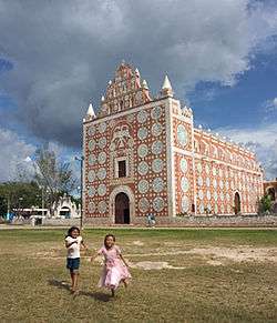
Principal Church of Uayma , Yucatán | |
 Region 6 Oriente #099 | |
|
Uayma Location of the Municipality in Mexico | |
| Coordinates: 20°43′N 88°19′W / 20.717°N 88.317°WCoordinates: 20°43′N 88°19′W / 20.717°N 88.317°W | |
| Country |
|
| State |
|
| Mexico Ind. | 1821 |
| Yucatán Est. | 1824 |
| Municipality Est | 1918 |
| Government | |
| • Type |
|
| • Municipal President | Juana Neyvi Chi Castro[2] |
| Area | |
| • Total | 196.72 km2 (75.95 sq mi) |
| [2] | |
| Elevation | 28 m (92 ft) |
| Population (2010[3]) | |
| • Total | 3,782 |
| • Density | 19/km2 (50/sq mi) |
| • Demonym | Umanense |
| Time zone | Central Standard Time (UTC-6) |
| • Summer (DST) | Central Daylight Time (UTC-5) |
| Postal Code | 97390 |
| Area code(s) | 988 |
| INEGI Code | 099 |
| Major Airport | Merida (Manuel Crescencio Rejón) International Airport |
| IATA Code | MID |
| ICAO Code | MMMD |
| Website | Official Website |
| Municipalities of Yucatán | |
Uayma Municipality (In the Yucatec Maya Language: “water not here”) is one of the 106 municipalities in the Mexican state of Yucatán, containing (196.72 km2) of land and located roughly 165 km east of the city of Mérida.[2]
History
There is no accurate data on when the town was founded, though it existed before the conquest and in antiquity belonged to the chieftainship of Cupules.[2] At colonization, Uayma became part of the encomienda system with the first recorded encomendero as Juan Bellido 1549-1579. From him it passed to Martín de Güemes 1579; Gaspar González, Pedro de Valencia, and Pedro de Valencia II 1607; Francisco Menéndez Morán 1683-1688; and thereafter to Joaquin Menéndez.[4]
Yucatán declared its independence from the Spanish Crown in 1821 and in 1825, the area was assigned to the partition of Valladolid Municipality. During the Caste War of Yucatán the city was abandoned but repopulated after federal troops regained possession of it. In 1918, it was designated as its own municipality.[2]
Governance
The municipal president is elected for a three-year term. The town council has four councilpersons, who serve as Secretary and councilors of public works, education, nomenclature and public monuments.[5]
Communities
The head of the municipality is Uayma, Yucatán. There are 16 populated areas of the municipality.[5] The most notable, after the seat, include San Lorenzo, Santa María Aznar, and Xkatbe. The significant populations are shown below:[2]
| Community | Population |
|---|---|
| Entire Municipality (2010) | 3,782[3] |
| San Lorenzo | 47 in 2005[6] |
| Santa María Aznar | 514 in 2005[7] |
| Uayma | 2434 in 2005[8] |
Local festivals
Every year on 3 May the festival of the Holy Cross is celebrated and on 15 May the feast of San Isidro Labrador, the town's patron saint is held. Also on 4 August a fiesta for Santo Domingo is recognized.[2]
Tourist attractions
- The ex-convent and Church of Santo Domingo, built in the seventeenth century, destroyed during the Caste War, and rebuilt in the 19th century is one of the most famous structures of the municipality.
References
- ↑ "Obstáculo al relevo en Uayma" (in Spanish). Mérida, Mexico: Diario de Yucatán. 23 August 2012. Retrieved 1 August 2015.
- 1 2 3 4 5 6 7 "Municipios de Yucatán »Uayma" (in Spanish). Retrieved 1 August 2015.
- 1 2 "Mexico In Figures:Uayma , Yucatán". INEGI (in Spanish and English). Aguascalientes, México: Instituto Nacional de Estadística y Geografía (INEGI). Retrieved 1 August 2015.
- ↑ García Bernal, Manuela Cristina (1978). Población y encomienda en Yucatán bajo los Austrias (in Spanish). Sevilla: Escuela de Estudios Hispano-Americanos. p. 524. ISBN 978-8-400-04399-5. Retrieved 1 August 2015.
- 1 2 "Uayma". inafed (in Spanish). Mérida, Mexico: Enciclopedia de Los Municipios y Delegaciones de México. Retrieved 1 August 2015.
- ↑ "San Lorenzo". PueblosAmerica (in Spanish). PueblosAmerica. 2005. Retrieved 1 August 2015.
- ↑ "Santa María Aznar". PueblosAmerica (in Spanish). PueblosAmerica. 2005. Retrieved 1 August 2015.
- ↑ "Uayma". PueblosAmerica (in Spanish). PueblosAmerica. 2005. Retrieved 1 August 2015.
Mérida (capital) | |||||||||||||||||||||||||||
| Topics |  | ||||||||||||||||||||||||||
| Metros | |||||||||||||||||||||||||||
| Larger cities | |||||||||||||||||||||||||||
| Smaller cities |
| ||||||||||||||||||||||||||
| Municipalities |
| ||||||||||||||||||||||||||